1938 FLOOD

pokerdad911

Full Member
Joined
Mar 25, 2008
Messages
191
Reaction score
1
Golden Thread
0
Location
O.C CA.
Detector(s) used
Whites Idx Pro - DFX
ALANTO , ANYONE HEARD OF THIS PLACE? 1938 flood took it out. It was near prado dam, i think. the town itself was in the santa ana river. any info? l was in the area in some old orange groves doing some detecting. Found an old machete by on old tree as if the guy who used it took a nap by the tree an left it as he went back to work. it was a sweet find. AREA OF TOWN IS SANTA ANA RIVER BY91 fwy & 71 hwy.lnfo please.
 

Part of a Spanish Land Grant...most likely a crossroads community without a postal address...not incorporated
 

I've heard of the towns of Prado and Rincon (maybe the same town with two different names) being swallowed up by the Prado Dam, but I've never heard of Alanto.
 

The area you describe is near Green River, where many of the notorious OC brush fires have originated from...

Its probably not unusual to find machetes lost in the brush...which doesn't mean that it has any relationship to the 1938 flooding...

The remains of the Yorba adobe is in the vicinity (just west), hence, the Spanish Land Grant reference...

I happen to have copies of the Spanish Land Grant maps and there is no reference to any community in the Prado Dam area...Dam was built in 1936...
 

hey gang,
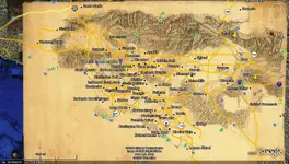
If I remember right wasn't there a town spelled LLanto ?? or something like that.. If you activate the " munsey " maps in google it will spread out a very nice 1880 map of LA that goes all past redlans due east and past Temecula and just north of Oceanside. Then Camarillo due W and finally as far north as Santa Clarit and Hesperia... It a overlay and is great for old roads....

PLL
 

Hey PLL,

Tell me more about this 'munsey map' thingy...

How's it work?

Man! That sounds like it could be great!

Thanks
rmptr
 

hey rmptr,
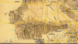
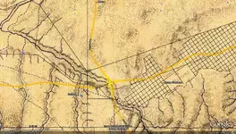
If you go to the sidebar in googlearth and look for munsey maps, click the box. Then this compass shows up on the maps. click on it and it wiil show the map... It's that easy.. Here's some pixs of the stuff


this is the compass thing
munslogo.webp

this is the map
munsla1880.webp

and if you go deep you can see some of the old town names
munsalvord.webp
 

Pokerdad:
Yes, there was an article written about the dam:
"Modern Prospecting-Prado Dam"
By Reggie Gould
Page 59 of the January issue of Lost Treasure magazine.
Unfortunately, I don't have that issue.
Don....
 

PLL, I got no sidebar in google maps...

so I ran the updater for google earth and got a sidebar there....

No Munsey maps.

Is it under some kind of category or something?

Is it only for LA?

I can't even find anything coherent on a google search for Munsey map!

Help!
;D
 

Hey rmptr,
If you engage the side bar and scroll down to layers ( expand it if you need to by clicking on the triangle ) and then scroll down within the layers till you see Munsey ( it right after natgeo ) then click on the box. After that you will get the compass' and then click on that and the map will appear. I'll warn you, after the map loads, google becomes very slow.

PLL
 

Top Member Reactions

Users who are viewing this thread

Latest Discussions

Back
Top Bottom