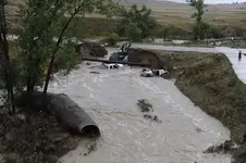
Well maybe not 20 feet, This took place just maybe 3-4 mile north of me early on in the storm and its just a small ravine. I live in Lafayette, Boulder County. I would think many streams in the foot hills north of Clear Creek would have been washed over very much so. Most have never been known for much gold, but the creeks up in around Jamestown and Gold hill would have been turned up a lot and they are the little streams the early gold prospectors of 1859 worked up to the load deposits in the foot hills of Boulder County. I would think that some of those ravines in western Boulder county that never saw much running water other then the normal annual spring run off would have had all that old alluviaum washed out and new from the banks washed in. There are gold mines up in that area of Jamestown and Gold Hill and those streams do produce some gold. Unlike the Big Thompson flood in the 70s that was one big rain storm in one river system, this storm was wide spread. Much of it over the gold areas in western Boulder County. Down here where I live these small creeks run in hard soil and that spontaneous rush of water cut though these small creeks like a band saw. I would think artifacts of all kinds buried for many years could be now exposed that fell in from the banks. The closest creek to me that runs year round is Coal Creek to my south and to the north is Boulder Creek. None of those were ever known gold producers. I saw Coal Creek the night of the storm and it was sure a sight to behold. The bike trail along Coal Creek is all gone, but I'm still going to go see what I can find that was under that trail for who knows how long? Could be bones or stone artitfacts?

")
