pa-dirt_nc-sand
Silver Member
- Joined
- Apr 18, 2016
- Messages
- 4,267
- Reaction score
- 15,088
- Golden Thread
- 2
- Location
- South Western PA
- 🥇 Banner finds
- 2
- 🏆 Honorable Mentions:
- 2
- Detector(s) used
- ACE 250 with DD coil
Equinox 600
- Primary Interest:
- Metal Detecting
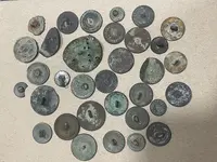
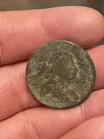
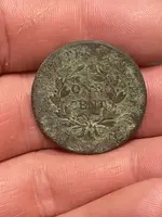
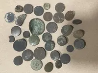
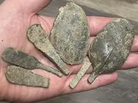
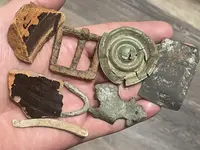
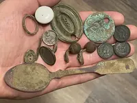
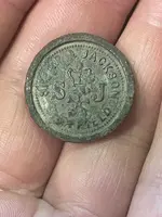
Decided to rehit a site I had researched and scouted in my home town park last year. It is a homesite from the 1910 map, only found a a couple things last year, also saw many open dig holes and chunks of iron leaning against tree trunks. I didn’t have high hopes but wanted to rehit it with the foliage down and also check out an old road bed adjacent to this cellar hole. The original site still popped out a handful of late 1800’s into the 1900’s coins and relics, but the old road bed lead to a very early untouched site! 35 flat buttons so far including several tombac. I believe the DB LC is 1802. With the rat tail pewter spoons, buttons and coin, I think this site is one of the post Rev War land allocation settlers. Most likely a log cabin, no foundation, no stones, no brick, no glass. Only 2 pottery pieces. It doesn’t show up on any of my maps except the vague outlines of the depreciation land map. My kind of site!! Fun times.


Attachments
-
 B8B49E0C-1B93-4A6D-8E1F-C02D242B051C.webp1.2 MB · Views: 207
 -
 582FCF21-14C6-407A-951B-C059DEDF0D85.webp589 KB · Views: 142
 -
 FFB04213-3391-4028-A542-AF3FE5AB9880.webp577.3 KB · Views: 143
 -
 2B54D5FB-36E2-40F6-8FBC-30ABFF819238.webp1.1 MB · Views: 129
 -
 38DBD420-8873-4DDF-B096-18B5241A0619.webp724.6 KB · Views: 126
 -
 7EB899A5-23FB-4797-8247-EFDE4AABF131.webp703.9 KB · Views: 125
 -
 55952E91-F0F3-414B-B2CF-51F9A10DE947.webp655.4 KB · Views: 133
 -
 83CAACFC-F650-4FB0-9484-28C0B8D8AB14.webp470.1 KB · Views: 147
Upvote
30

