Don in SJ
Silver Member
- Joined
- May 20, 2005
- Messages
- 4,937
- Reaction score
- 852
- Golden Thread
- 0
- Detector(s) used
- MINELAB SE Pro
- Primary Interest:
- All Treasure Hunting
- #1
Thread Owner
Albany Twp, Berks County & West Penn Twp, Schuylkill County - Help
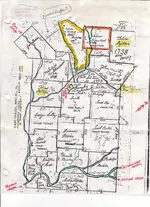
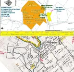
I was looking at some of my old maps I have stored on the computer and there is one from 1753 for Albany Twp, Berks County. At first I thought perhaps Jeff sent it to me but with the markings that are written on the map, I think it is from someone doing genealogy that sent me the map, since it appears that it shows one of my 5th great grandfather's 150+ acre farm on the map.
Right now I am having a bit of trouble of figuring out exactly where the farm would be located, no roads show, it is a property outline map and only streams and few other possible lanmarks show, but the farm was straddling what is called Pine Creek not far from a church called New Bethel Church in 1753.
Hawk Mtn appears north and maybe a tad to the west of the site, just not sure. The church is on another stream that joins the one named Pine Creek on the map.
I have not looked at all the online maps yet and I am sure I can find it, but when I do, I might want to get together with someone in that area and do a hunt. Jeff knows I also had relatives in his county, in West Penn Twp, East Brunswick, Lynn Twp and McKeensburg plus some others I can't remember right now.
So, I am attaching the map, and would like to know where the church is located by road name on modern maps, My 5th great grandfather and his wife are most likely buried there.
Note: the highlights on the map are not mine, nor do I think my relatives, this map came from else.
else. ")
Don
I was looking at some of my old maps I have stored on the computer and there is one from 1753 for Albany Twp, Berks County. At first I thought perhaps Jeff sent it to me but with the markings that are written on the map, I think it is from someone doing genealogy that sent me the map, since it appears that it shows one of my 5th great grandfather's 150+ acre farm on the map.
Right now I am having a bit of trouble of figuring out exactly where the farm would be located, no roads show, it is a property outline map and only streams and few other possible lanmarks show, but the farm was straddling what is called Pine Creek not far from a church called New Bethel Church in 1753.
Hawk Mtn appears north and maybe a tad to the west of the site, just not sure. The church is on another stream that joins the one named Pine Creek on the map.
I have not looked at all the online maps yet and I am sure I can find it, but when I do, I might want to get together with someone in that area and do a hunt. Jeff knows I also had relatives in his county, in West Penn Twp, East Brunswick, Lynn Twp and McKeensburg plus some others I can't remember right now.
So, I am attaching the map, and would like to know where the church is located by road name on modern maps, My 5th great grandfather and his wife are most likely buried there.
Note: the highlights on the map are not mine, nor do I think my relatives, this map came from
else. Don


 Will look fruther tomorrow
")
