Any Suggestions - What is the name of this Bahamas Wreck?

Old Bookaroo

Silver Member
Joined
Dec 4, 2008
Messages
4,580
Reaction score
4,006
Golden Thread
0
Ahoy!

I was looking at this chart:

Bahamas Map #2.webp

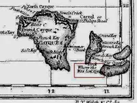
And noticed this:

Bahamas Map #1.webp

Does anyone have a suggestion what vessel was "Lost" here? Assuming I am reading this correctly.

Thank you!

Good luck to all,

The Old Bookaroo, Cm
 

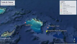
I believe that the location that this indicates is Endymion Rock in the Turks and Caicos, not the Bahamas.
21° 6'17.78"N
71°19'11.89"W

From Wikipedia, the rock was "named for the (HMS Endymion (1779), launched in 1779, was a 44-gun Roebuck-classfifth rate. She was wrecked on a coral reef near the Turks and Caicos Islands in 1790."

There was an expedition to map wrecks in the vicinity in 2007- Turks & Caicos: Endymion Rock - Waitt Institute

I haven't looked it up in The Shipwreck Guide to the Bahamas, Turks and Caicos, but I will if you'd like.
Here's the Google Earth shot of the region. I believe it matches up pretty well.
Endymion R.webp


ropesfish:

Many thanks! I certainly appreciate your good help! The "Bahamas" came from the name of the Chart. It didn't have a date. I don't know, of course, where the cartographer got the "1702" date (if I read it correctly) and if it's a wreck (I'm assuming it is from "Lost...").

Good luck to all,

The Old Bookaroo, CM
 

BVI hunter is your guy then......
 

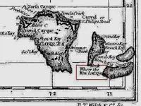
I played with the contrast and brightness on this section of the map. I don't believe that the date is 170_, I believe it is 179_. The last number is not very clear either.
It did not "save" in it's magnified condition. On my Chrome browser I can right click on the picture, then click "Open in a new tab". I then can go to that tab, hit CTRL and scroll with my mouse to zoom in. At 200% to 400% zoom the 3rd number in the date looks pretty clear.

adjusted map.webp

2nd try. If nothing else, save the picture and open it in Paint or some other image editor:
adjusted map1.webp
 

Last edited:
Jolly Mon:

My sincere thanks to you - and to ropesfish and SADS 699 who took the time to respond! I sincerely appreciate it - and I hope, in the future, to be able to repay the favor. This is the real TN!

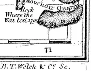
I think you solved my confusion. This resolution is better and, indeed, the date is "1792." Looks like the cartographer ran out of room to name the wreck.

Bahamas #3.webp

I didn't provide a link because I want to be careful about TN's rules regarding "other" sites. I'm not sure how that is defined.

Again, many thanks!

Good luck to all,

The Old Bookaroo, CM
 

If you want me to put you in touch with BVI send me a pm. I know he knows of lots of " areas" in the Turks you might be able to link this to.

We found a wreck marked on a chart in the map room in London's British library no one had ever heard of?
 

SADS 669:

Thank you for your generous offer! This was mild curiosity, nothing more. I was trying to help someone else on another project and stumbled across this.

I think the old charts provide useful information that some people could well benefit from. Look at how well Kip Wagner did!

Good luck to all,

The Old Bookaroo, CM
 

The date is 1792. I found it on a better copy of the chart.
 

SADDS - THANKS

its not HMS Endymion - although the map is typically out of proportion, given places I know well - SALT CAY, GRAND TURK, NORTH CAICOS etc I would say its one (of a few) wrecks been 'discovered" in the last few years by local teams I the area of the TCI
Kevin, our discovery from the Greenwich museum has yet to be worked on!
 

BVI Hunter:

Do you find it odd the name of the vessel wasn't on the chart? There's room for a third line. The cartographer knew the date and I'm thinking the loss was contemporary (more or less) with the drawing of the chart.

Good luck to all,

The Old Bookaroo, CM
 

Top Member Reactions

Users who are viewing this thread

Latest Discussions

Back
Top Bottom