Desert Hermit
Jr. Member
- Joined
- Feb 1, 2014
- Messages
- 86
- Reaction score
- 75
- Golden Thread
- 0
- Location
- Randsburg, California
- Detector(s) used
- MineLab GPX 5000
- Primary Interest:
- Prospecting
I just ran across this info on a website:
A Quick Guide to Finding BLM Mining Claims with the MinerDiggins Gold Atlas
By Ruby Miner
The USGS provides an information website called the GeoCommunicator. This website used to be a "One-Stop" shop for finding information about land status, mining claims, grazing allotments and much more. This website has stopped providing much of the information useful to prospectors, such as mining claims and land status.
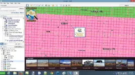
We have created the - MinerDiggins Gold Atlas to help fill the void left by these changes. The Gold Atlas uses Google Earth to display data that can aid prospectors in their search for Gold.
I downloaded it here: MinerDiggins Gold Atlas it's toward the last section of the page.
This thing is loaded with data and you really have to be selective in the column on the left or it'll take forever to load.
Just wondering if anyone has used this and if so would you recommend it?

Upvote
0


