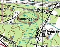
Probably wrong, but I keep thinking of an old sewage treatment plant. Long straight line could be buried pipeline, and there used to be a creek to discharge into.
Behind my house in Tewksbury Ma.
- Thread starter Sandmaniac
- Start date


Top Member Reactions
-
 2306
2306 -
 1485
1485 -
 1352
1352 -
 1327
1327 -
 1098
1098 -
 1036
1036 -
 945
945 -
 812
812 -
 749
749 -
 591
591 -
 577
577 -
 564
564 -
 545
545 -
 497
497 -
 476
476
