Better Than Google Earth?

West Jersey Detecting

Gold Member
Joined
Oct 23, 2006
Messages
5,247
Reaction score
1,066
Golden Thread
1
Location
Philadelphia Area
🥇 Banner finds
1
🏆 Honorable Mentions:
1
Detector(s) used
Nokta Legend, Excalibur 1000/II (hybrid) , Teknetics T2 SE
Primary Interest:
Other
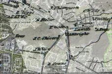
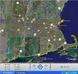
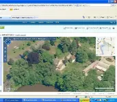
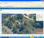
I have been using Google Earth to find potential metal detecting sites almost since it's introduction a few years back. I recently learned that MSN's Virtual Earth has it's own online aerial photos with quality that blows away Google Earth's. http://maps.live.com/ The birdseye views allow you to pan from 4 different directions. Here is a screencap of Google Earth's image, and in my reply I will post the birdseye views using MSN's maps.

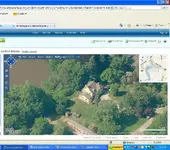
Google Earth still has many advantages over MSN, especially if you use a GPS device, but for clarity at low altitudes, MSN wins hands down.
 

Attachments

  • Evans GE.webp
    Evans GE.webp
    57.8 KB · Views: 719
MSN image 1
 

Attachments

  • EvansMSN01.webp
    EvansMSN01.webp
    108.8 KB · Views: 708
MSN Image 2
 

Attachments

  • EvansMSN02.webp
    EvansMSN02.webp
    100.3 KB · Views: 706
MSN Image 3
 

Attachments

  • EvansMSN03.webp
    EvansMSN03.webp
    98.7 KB · Views: 712
Wow! I rely on Google Earth so much, I'll have to try this one out! Now...if there was a way to adjust the time of day so that I can see all the irregularities in plowed fields... ;) ...well...maybe that's too much to ask.


-Buckles
 

Oh man, that's amazing! Will it let you scroll with the wheel on your mouse, and zoom right where your mouse is currently on the map like Google Maps (online, not Google Earth)? Just wondering. Either way, those shots are astonishing!! That's going to help me out alot... thanks for the tip!!!

Bran <><
 

Bran:

You can use the mouse the same way as Google Earth, however since the photos are taken at lower altitudes it is made up of many more photos than Google Earth. Sometimes it does not load as quicky as Google Earth does while scrolling, especially when you cross from one image to the next.

Another advantage is that there is no program to download.
 

Well I like not needing to download a program for it. It would be nice if it were optional, but it's definitely not needed. Better to rely on broadband Internet connection, than use up more computer memory...
I'm about to get my wireless mouse for my laptop and give it a try. Thanks again!

Bran <><
 

Well I just used my Logitech Media Mouse, that a multi-function scroll wheel for side to side and in and out... and back & forward buttons on the side. I just have to say that these Live Search Maps just stinkin' BLEW Google Earth out of the water for everything I'll ever need it for! I'm searching some of the coastline around my area for some new places to hunt. Thanks for heads up on this! I'll be showing my brother tomorrow... he's gonna be so stoked by this!

Bran <><
 

I have been using maps.live for awhile and the birds eye view is great. The regular aerial view though is not as good as google earth. I always check maps.live first to view the area I want to look at and if the tab for "birds eye view" is not highlighted, I go to google earth. It may seem kind of odd when you rotate the image because you are actually viewing a complete new shot that was taken at another time so the scene may be different. The trees may be green in one view then rotate and it may be fall with no leaves, rotate again and may be snow on the ground.
 

I have used that site for a while Neil---Much better than Google.
 

I've played with Goggle Earth some and found it lacking. These new search engines are much better.

Thanks for the heads up. :)
 

Sandman said:
I've played with Goggle Earth some and found it lacking. These new search engines are much better.
Thanks for the heads up. :)

Don't get me wrong, there are many advantages to using Google Earth over other programs. The Image Overlay feature allows you to overlay old maps over new, such as this image which shows an 1859 map overlay. I use the push pin to mark structures on the old map, and then I toggle off the overlay, leaving behind a push pin to mark the spot. I then enter the coordinates on my GPS (especially important in those remote locations).

Other features include the ruler which allows you to measure distance, and the ability to toggle off features. The Google Earth Community will also give you hints for good detecting sites as well. There are many more advantages to Google Earth over other programs and sites, just experiment and see what happens.

As for me, I use all of these programs and sites in tandem. Historic Topos, Old Insurance maps, modern topos, and more. When combined they are powerful tools that give the experienced treasure hunter a huge advantage over the weekend warriors.
 

Attachments

  • 1858 Overlay.webp
    1858 Overlay.webp
    149.7 KB · Views: 461
Neil in West Jersey said:
Don't get me wrong, there are many advantages to using Google Earth over other programs. The Image Overlay feature allows you to overlay old maps over new, such as this image which shows an 1859 map overlay. I use the push pin to mark structures on the old map, and then I toggle off the overlay, leaving behind a push pin to mark the spot. I then enter the coordinates on my GPS (especially important in those remote locations).

Other features include the ruler which allows you to measure distance, and the ability to toggle off features. The Google Earth Community will also give you hints for good detecting sites as well. There are many more advantages to Google Earth over other programs and sites, just experiment and see what happens.

As for me, I use all of these programs and sites in tandem. Historic Topos, Old Insurance maps, modern topos, and more. When combined they are powerful tools that give the experienced treasure hunter a huge advantage over the weekend warriors.


I absolutely agree, and I do exactly what your speaking of with pretty decent results.
Even beyond the results though, I find the process of interacting between google earth and the old maps to be very enjoyable in and of itself. I also like to mark out the potential treasure locations along with locations were I have already found treasure, just for reference.

Here is an example of some of the type of pinpoints that I keep. I had to shut some stuff off for this picture, as it was to clustered up and wasn't clear enough to read on-line.

The other image is a collection of 1800's maps I have stored on my computer that I use in the overlays or just by themselves. In addition to these I have numerous hard copies of other areas. I'm kind of an old map type of guy.


Johnny Cache Hunter
 

Attachments

  • Google Pinpoints.webp
    Google Pinpoints.webp
    121.8 KB · Views: 361
  • MDing Maps and More.webp
    MDing Maps and More.webp
    60.7 KB · Views: 355
The only problem that I see is that in rural areas the zoom feature is limited. You can't zoom in as far close as Google earth.
 

Definately gonna check out that link...google earth doesnt have pics of some of the rural areas near me at all...just colored globs....and from a guy I work with that lives in the area, there are many old foundations and history in his area.
It sucks not being able to even have a fair aerial view.
Al
 

Dang...just checked it out...and not only do they have pics of areas google don't...they are a lot more recent. #D not so great on my puter, but seeing the overheads is great.
Al
 

Top Member Reactions

Users who are viewing this thread

Back
Top Bottom