Big Rosette, Two 1812 Halfpenny’s, 1807 KGIII Penny and other Relics

ANTIQUARIAN

Gold Member
🥇 Charter Member
Joined
Apr 24, 2010
Messages
12,923
Reaction score
27,656
Golden Thread
1
Location
Upper Canada 🇨🇦
🥇 Banner finds
1
🏆 Honorable Mentions:
3
Detector(s) used
XP Deus, Lesche Piranha 35 Shovel & 'Garrett Carrot'
Primary Interest:
Relic Hunting

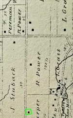
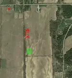
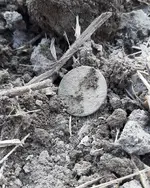
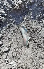
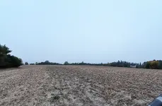
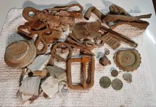
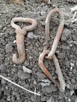
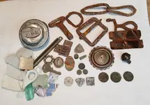
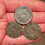
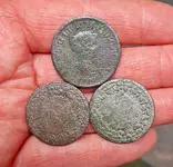
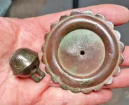
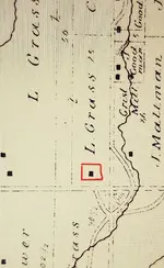
It took me almost 2 years to find this site in the field where I found the Halfpenny’s, the rosette and the KGIII. I originally found this site identified in an 1870 county atlas in 2018. Unfortunately, I had a very short window each year to search for it, as this farmer keeps his fields in tight crop rotations. One week ago, the beans came off this field, the farmer has disked and is planting winter wheat later this week. I was fortunate that he gave me the go-ahead to look for the site on Sunday and Monday.

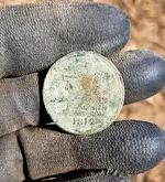
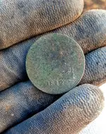
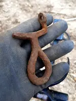
I arrived at the field at 6:30 am on Sunday and didn't find the site until 11:30 am, I then only had 2hrs left to detect it. I first found the 1807 KGIII followed by a very large horse rosette, then an 1812 LC Halfpenny. Luckily, I had a few hours to head back on Monday and found another 1812 LC Halfpenny. I now have to wait until next June before I can detect it again.

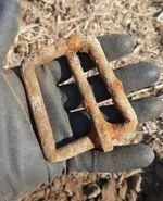
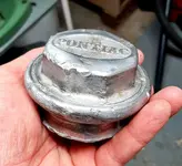
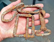
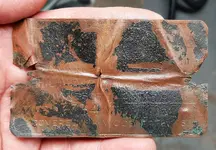
I’ve also included finds from two other sites that I detected last week. :thumbsup:

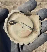
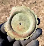
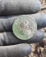
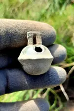
Lower Canada Halfpenny Token - 1812
Features King George III and Lady Justice with her scales making a statement about the War of 1812 between America and the British Empire, including Canada. These tokens were struck by private mints to help fill the need for currency which was sorely lacking at the time. These tokens are quite common and are worth small amounts unless in excellent condition. Just about all of these tokens that I’ve found are very thin and are heavily worn.


Thanks very much for looking,
Dave
 

Attachments

  • 20200929_154958.webp
    20200929_154958.webp
    289.8 KB · Views: 119
  • Screenshot_2020-09-26 Google Earth.webp
    Screenshot_2020-09-26 Google Earth.webp
    50.9 KB · Views: 101
  • 20200927_065342_resized.webp
    20200927_065342_resized.webp
    162.3 KB · Views: 95
  • 20200927_100257_resized.webp
    20200927_100257_resized.webp
    297.4 KB · Views: 80
  • 20200927_105818_resized.webp
    20200927_105818_resized.webp
    534.6 KB · Views: 106
  • 20200927_122223_resized.webp
    20200927_122223_resized.webp
    621.8 KB · Views: 74
  • 20200929_152019_resized.webp
    20200929_152019_resized.webp
    360.2 KB · Views: 80
  • 20200929_152041_resized.webp
    20200929_152041_resized.webp
    450.8 KB · Views: 122
  • 20200929_152059_resized.webp
    20200929_152059_resized.webp
    591.9 KB · Views: 83
  • 20200927_105757_resized_1.webp
    20200927_105757_resized_1.webp
    530.5 KB · Views: 82
  • 20200929_122222_resized.webp
    20200929_122222_resized.webp
    605.5 KB · Views: 103
  • 20200929_073825_resized.webp
    20200929_073825_resized.webp
    777.9 KB · Views: 103
  • 20200929_073803_resized.webp
    20200929_073803_resized.webp
    533.5 KB · Views: 76
  • 20200925_074234_resized.webp
    20200925_074234_resized.webp
    286.2 KB · Views: 75
  • 20200925_153359_resized.webp
    20200925_153359_resized.webp
    642.6 KB · Views: 92
  • 20200927_151928_resized.webp
    20200927_151928_resized.webp
    399.3 KB · Views: 99
  • 20200921_153720_resized.webp
    20200921_153720_resized.webp
    155.7 KB · Views: 100
  • 20200925_074017_resized.webp
    20200925_074017_resized.webp
    651 KB · Views: 97
  • 20200925_083424_resized.webp
    20200925_083424_resized.webp
    304.1 KB · Views: 71
  • 20200925_153344_resized.webp
    20200925_153344_resized.webp
    416.9 KB · Views: 94
  • 20200929_144033_resized.webp
    20200929_144033_resized.webp
    324.1 KB · Views: 95
  • 20200929_150715_resized.webp
    20200929_150715_resized.webp
    571.8 KB · Views: 69
  • 20200929_150333_resized.webp
    20200929_150333_resized.webp
    427 KB · Views: 79
  • 20200929_151406_resized.webp
    20200929_151406_resized.webp
    229.3 KB · Views: 114
  • 20200929_151343_resized.webp
    20200929_151343_resized.webp
    259.9 KB · Views: 112
  • 20200929_151923_resized.webp
    20200929_151923_resized.webp
    269.2 KB · Views: 107
  • 20200929_151847_resized.webp
    20200929_151847_resized.webp
    441.2 KB · Views: 99
  • 20200929_151759_resized.webp
    20200929_151759_resized.webp
    281.1 KB · Views: 90
  • 20200929_150929_resized.webp
    20200929_150929_resized.webp
    393.7 KB · Views: 104
Upvote 39
Now that you have the area scoped out, can you imagine the anticipation you'll build between now and June? Fine hunt and good luck!

Thank you for your post and words of support smallfoot. :thumbsup:
There's another house close by identified on the old map here as well, I just haven't found it yet.


Great recon work finding this site! Your hard work paid off! Congrats!

Thanks for your post Bart.
Best of luck to you in Oklahoma,
Dave


Wow!! Nice job Dave

Thanks very much Bob. :wave:
Hope you're having a good year!


Hello Anton, I appreciate your advice and support buddy! :occasion14:
It's always been one of my personal rules not to detect after the field's been planted. The farmers in my area have been very generous with their permissions to detect their fields and there's more then enough sites for me to investigate until the crops are harvested. I'm just waiting for two large sites to be disked for next years planting now that the wheat grass has been sprayed. These sites produced well after the winter wheat came off, but I just know there's more to be found. :icon_thumright:
Hope you're having a great year,
Dave


That was my personal rule until a few years or so ago. Until one of the farmers asked me why am I wasting my time walking on a plowed field when I could wait for him to level it during the seeding season. I refused to do it for a few years until he finally convinced me. Couldn't believe the difference! Don't forget, they go on it with their huge tractors long after the crops are seeded. And as I have mentioned, I never did any damage to the crops and if I noticed an even tiniest difference I would stop doing it right away. I think for us not being farmers it is hard to comprehend how tough those crops are (I'm talking about soy, corn and wheat).
Good luck with your other fields, hopefully this fall will be long and sunny. Last year wasn't that great over here with lots of rain, but so far so good.
 

Last edited:
That was my personal rule until a few years or so ago. Until one of the farmers asked me why am I wasting my time walking on a plowed field when I could wait for him to level it during the seeding season. I refused to do it for a few years until he finally convinced me. Couldn't believe the difference! Don't forget, they go on it with their huge tractors long after the crops are seeded. And as I have mentioned, I never did any damage to the crops and if I noticed an even tiniest difference I would stop doing it right away. I think for us not being farmers it is hard to comprehend how tough those crops are (I'm talking about soy, corn and wheat).
Good luck with your other fields, hopefully this fall will be long and sunny. Last year wasn't that great over here with lots of rain, but so far so good.

Thanks for your post Anton, I apologize for the late follow up response. :thumbsup:

For some reason, it just doesn't feel right in my gut when I detect a field that's been planted. That having been said, I have detected in farm fields that were planted with corn.
The corn was a foot tall and I was swinging in between the rows, being careful not to dig up any of the young stalks.

If I ever did receive permission directly from the farmer that it was OK as long as I was careful, I'd probably give it a shot.
I've always wondered what I'm missing when I'm swinging over the ridges & furrows. :icon_scratch:

Hope you have a productive fall too buddy,
Dave
 

Nice finds Dave, nice pix as usual, I've been looking and waiting for my fields to be harvested, got my eye on some new ones to try this year!
 

Excellent research and resulting finds, as always. Well Done!
 

Nice finds Dave, nice pix as usual, I've been looking and waiting for my fields to be harvested, got my eye on some new ones to try this year!

Thanks for your post Brad.
Best of luck when you're able to get back in the fields, beans are done here, just waiting for the corn to come off. :thumbsup:


Excellent research and resulting finds, as always. Well Done!

Thanks very much Nick. :icon_thumleft:
Hope you're doing well these days.
Dave
 

Congratulations on a great group of finds.

You know this site better than anyone and may already know the answer, but do you think the original "horizontal" road in the old map could have been in a different location than where it is now?

The only reason I ask is because of the slight "bend/stream" that appears in the upper left of the map seems to be evident in the satellite image as well. If they are the same then it looks like the modern road is situated too close to the "bend/stream?

I've included your two images with arrows that hopefully will show what I'm talking about. (Hope it is ok to mark up your images with arrows.)
This might help narrow down your search areas for other home sites on this permission. (This is another one of those times I wish I knew how to do overlays.)

AntiquarianColinialSiteScreenshot_2020-09-26 Google Earth_Arrow.webpAntiquarianColonialMap20200929_154958Arrows.webp

PP55
 

Congratulations on a great group of finds.

You know this site better than anyone and may already know the answer, but do you think the original "horizontal" road in the old map could have been in a different location than where it is now?

The only reason I ask is because of the slight "bend/stream" that appears in the upper left of the map seems to be evident in the satellite image as well. If they are the same then it looks like the modern road is situated too close to the "bend/stream?

I've included your two images with arrows that hopefully will show what I'm talking about. (Hope it is ok to mark up your images with arrows.)
This might help narrow down your search areas for other home sites on this permission. (This is another one of those times I wish I knew how to do overlays.)

View attachment 1871420View attachment 1871421

PP55

This is an interesting theory Pete, I never thought of that before? :icon_scratch:
I did hunt the site in the top right-hand corner of the map just below where you indicated the red 'X'.

This structure turned out only to be a barn, so I'm fairly certain the road wasn't located further south.
As I'm sure you know, streams change their courses pretty regularly, at least they do in my area.

I'll post a pic of the upper right corner of the map below, along with a pic of the site where I found the finds in this post when I first investigated it last winter.

I just don't think I've found the site I've indicated in red yet, I think I need to look on higher ground and a little further north.
Thanks again for your help, that's very considerate of you. :thumbsup:
 

Attachments

  • Pics019.webp
    Pics019.webp
    220.2 KB · Views: 35
  • Pics010.webp
    Pics010.webp
    271.1 KB · Views: 47
Last edited:
Alot of hard work went into this research and hunting thank you for the many really good pictures
 

Alot of hard work went into this research and hunting thank you for the many really good pictures

Thanks for your post Mark. :thumbsup:
In all honesty, being able to prove my research by actually finding the site is a real rush.

Take care,
Dave
 

Wow! That's a lot of relics. It looks like you went too close to that coin :thumbsup:
 

...... I did hunt the site in the top right-hand corner of the map just below where you indicated the red 'X' ..
My apologies for making my 'X' red as it was only intended to be part of the question about your :cross: and not about a specific area of the map.
I misunderstood and thought your red :cross:'s, in the first images, were areas you found the items in this post.


..... I'll post a pic of the upper right corner of the map below, along with a pic of the site where I found the finds in this post when I first investigated it last winter. ......

I'll look forward to it. So the original image of the map and satellite image or the same general area, correct?
 

Wow! That's a lot of relics. It looks like you went too close to that coin :thumbsup:
Thank you for taking the time to post to my post Vince. :occasion14:
I look froward to getting back here after the wheat is harvested next year.
Dave


My apologies for making my 'X' red as it was only intended to be part of the question about your :cross: and not about a specific area of the map.
I misunderstood and thought your red :cross:'s, in the first images, were areas you found the items in this post.

I'll look forward to it. So the original image of the map and satellite image or the same general area, correct?

Thanks again for your insight here PetesPockets.
I'm going to respond to your PM now. :icon_thumright:
Dave
 

That's a lot of very cool finds in such little hunting time. I am very impressed! I hunt in our crops when it is corn. I follow the advice I read on here before: OK for corn till they are knee high, if you stay between rows/stay out of the soy beans. I don't know about wheat. That being said, I discussed this with our farmer and he told me not to worry about it either way. He said there was no way I could damage the crops as much as the deer and ground hogs do. And we share crop, so there's that. Still, I have the ability to hunt anytime when it is all harvested, so I just wait.

Congratulations on the very cool relics!
 

Very productive hunt! :occasion14:
 

That's a lot of very cool finds in such little hunting time. I am very impressed! I hunt in our crops when it is corn. I follow the advice I read on here before: OK for corn till they are knee high, if you stay between rows/stay out of the soy beans. I don't know about wheat. That being said, I discussed this with our farmer and he told me not to worry about it either way. He said there was no way I could damage the crops as much as the deer and ground hogs do. And we share crop, so there's that. Still, I have the ability to hunt anytime when it is all harvested, so I just wait.

Congratulations on the very cool relics!

Thank you for your post WD. :wave:
Hunting the corn rows is always challenging, I only do it after the harvest though, not after the fields have been planted.
Every farmer is different I guess.

Best of luck to you detecting after the harvest in your area.
Dave


Very productive hunt! :occasion14:

Thanks very much Professor. :thumbsup:
 

Very well done sir.
 

Glad to see your pulling all those great coins out. Thats a dream day for me my friend.. Keep em coming.....Tommy
 

Congratulations on a great group of finds.

You know this site better than anyone and may already know the answer, but do you think the original "horizontal" road in the old map could have been in a different location than where it is now?

The only reason I ask is because of the slight "bend/stream" that appears in the upper left of the map seems to be evident in the satellite image as well. If they are the same then it looks like the modern road is situated too close to the "bend/stream?

I've included your two images with arrows that hopefully will show what I'm talking about. (Hope it is ok to mark up your images with arrows.)
This might help narrow down your search areas for other home sites on this permission. (This is another one of those times I wish I knew how to do overlays.)

View attachment 1871420View attachment 1871421

PP55

In the historical maps/atlas that were produced in Ontario it will show the deeded concessions(road) that are still crown land today. These will never be sold or closed to the property owner (that I have heard of)
These will run through a property and separated the deeded lots and parcels.
It's easy to draw a line on the paper-but when it comes time to build the actual road it may follow the mapped out version and many times they don't because of the actual topography of the land.

I have no less than 9 streets, 1 Hwy, and 1 concession running along and through the property. Only 1 street is used and the HWY borders the field. The rest is on the maps and are unassumed streets.

Dave the permissions that we get are well received and as you I respect the time we get to dig on these permissions.
Some don't care if I dig on a hay field as they know a few blades of grass won't change anything for the big picture.
Some don't want no detecting on the hay fields while the grass is growing-then on the crop rotation it's fill your boots.
Each owner is different-each has their own reason-each is respected for that decision.
 

Top Member Reactions

Users who are viewing this thread

Back
Top Bottom