This isn't the kind of monument that qualifies for penalties, as far as I know.
The markers and monuments that you can't (or shouldn't move) are clearly marked as such.
Anyway, as for how the marker got to where it was found, there are several possibilities.
One is that it was simply covered over during construction of the road. (i.e., in the way, no longer needed, and not worth recovering beforehand). Just bulldozed over.
Another possibility is that leftover fill dirt from the original road construction (or even its later re-construction) made it's way onto the property where it was eventually found.
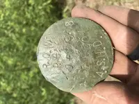
Also, this wasn't a "specially cast" bronze puck. It's a blank puck that was hand-stamped in the field.
They probably had dozens of them on the survey truck.
For that matter, I suppose (although it seems unlikely) that this was a mis-stamped puck, and whoever screwed it up simply whizzed it off in some random direction like a Frisbee, never to be seen again. Except you found it!
")
But to your point, I wouldn't lose any sleep over it.
It's not quite as important a marker as say..., the Four Corners Monument.
https://en.wikipedia.org/wiki/Four_Corners_Monument
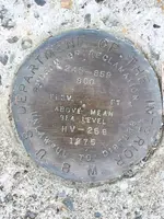
Edit: I should also add that occasionally you'll come across something called a "Witness Marker".
These often look similar, but they are not marking the original point.
Either the original marker got disturbed, or maybe a building, freeway, man-made lake, etc... covered it over.
In that case, the surveyors will erect a new marker (i.e., a witness marker) that is surveyed to a known exact position from the original marker.