
- Feb 2, 2013
- 1,441
- 2,028
- Detector(s) used
- Many
- Primary Interest:
- All Treasure Hunting
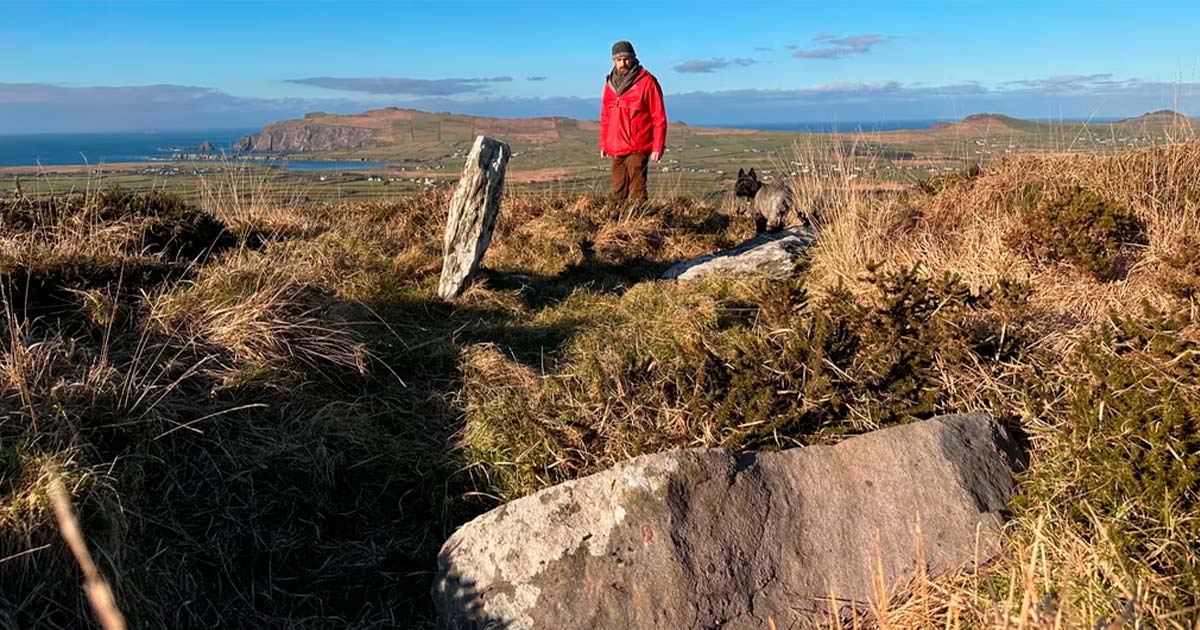
Thanks to the keen eye of local folklorist Billy Mag Fhloinn, and subsequent validation by archaeologist Caimin O’Brien, the finding of the remains of a legendary Bronze Age megalithic tomb ‘Altóir na Gréine’ has been confirmed in Ireland.
Local traditions in County Kerry, Ireland, told of the destruction of an ancient tomb in the 19th century. But now, a folklorist has found the lost “wedge-shaped” tomb, which was aligned with the solar solstice axis.
When Bronze Age Tombs Are Lost And Found:
With its sublime scenery, majestic mountains and rugged coastline, County Kerry is a popular place for visitors to the Atlantic coast of Ireland. Now, a folklorist has rediscovered the Bronze Age tomb known as Altóir na Gréine, “the Altar of the Sun,” that was always believed to have been destroyed in the 19th century.
In 1838, Lady Georgiana Chatterton, an English aristocrat and traveler, visited the site and sketched the monument. She described the site as a “curious piece of antiquity,” and she suggested it was used for offering sacrifices to the Sun. And in 1852, antiquarian and librarian Richard Hitchcock reported that by then the tomb had been destroyed, and that its stones had been robbed for building purposes.
While a burial tomb was recorded near Baile an Fheirtéaraigh in the 19th century, the monument's exact location was lost. But now, the burial tomb, dating back approximately 4,000 years, is back.
Challenging Local Taboos:
As part of a recent archaeological mapping project, local folklorist Billy Mag Fhloinn first identified stones on the crest of a hill, which he later matched with the hill depicted in Lady Chatterton’s sketch. Fhloinn’s primary research identified numerous large upright orthostats and a capstone, challenging local traditions that that the tomb was entirely destroyed in the mid-19th century.
Mag Fhloinn produced a 3D scan which he sent to the National Monuments Service in Dublin. Archaeologist Caimin O’Brien confirmed that the stones represented about a quarter of the original Bronze Age wedge tomb, dating between 2500 BC and 2000 BC. Folklorist Mag Fhloinn thinks “the taboo” surrounding the destruction of such tombs is related to 19th century beliefs “in bad luck or disaster associated with their demise”.
Archaeologist Caimin O’Brien told RTÉ that the rediscovered Bronze Age tomb will now become part of “a deep-mapping project,” that is being conducted by the U.S. Sacred Heart University. This involves scanning ancient structures and generating 3D models of burial tombs on the Dingle Peninsula, on Ireland’s southwest Atlantic coast.
Already, Tony Bergin, president of the Kerry Archaeological and Historical Society, finds similarities between the rediscovered Irish tomb and similar structures in Brittany, France. For example, the contemporary allées couvertes tomb in Brittany, which was associated with ancient copper miners.
Around 4,000-years-ago a new architectural style was born, known as “wedge tombs,” and these so-called “stone galleries” were narrower and shorter at the eastern end. Most often covered by a mound of earth, this distinctive building style flourished for about 500 years, and archaeologists find they were oriented towards the Sun at key stages in its annual cycle.
Wedge tombs emerged at the dawn of the Copper Age, during a period of rapid population expansion, when new copper farming technologies and methodologies were being developed. According to an article on RoaringWaterJournal.com, Irish archaeologists speculate that wedge tombs mark the emergence of new continental technologies, styles of pottery and metalworking, married with existent indigenous Irish chambered tomb building styles.
 www.ancient-origins.net
Local traditions in County Kerry, Ireland, told of the destruction of an ancient tomb in the 19th century. But now, a folklorist has found the lost “wedge-shaped” tomb, which was aligned with the solar solstice axis.
When Bronze Age Tombs Are Lost And Found:
With its sublime scenery, majestic mountains and rugged coastline, County Kerry is a popular place for visitors to the Atlantic coast of Ireland. Now, a folklorist has rediscovered the Bronze Age tomb known as Altóir na Gréine, “the Altar of the Sun,” that was always believed to have been destroyed in the 19th century.
In 1838, Lady Georgiana Chatterton, an English aristocrat and traveler, visited the site and sketched the monument. She described the site as a “curious piece of antiquity,” and she suggested it was used for offering sacrifices to the Sun. And in 1852, antiquarian and librarian Richard Hitchcock reported that by then the tomb had been destroyed, and that its stones had been robbed for building purposes.
While a burial tomb was recorded near Baile an Fheirtéaraigh in the 19th century, the monument's exact location was lost. But now, the burial tomb, dating back approximately 4,000 years, is back.
Challenging Local Taboos:
As part of a recent archaeological mapping project, local folklorist Billy Mag Fhloinn first identified stones on the crest of a hill, which he later matched with the hill depicted in Lady Chatterton’s sketch. Fhloinn’s primary research identified numerous large upright orthostats and a capstone, challenging local traditions that that the tomb was entirely destroyed in the mid-19th century.
Mag Fhloinn produced a 3D scan which he sent to the National Monuments Service in Dublin. Archaeologist Caimin O’Brien confirmed that the stones represented about a quarter of the original Bronze Age wedge tomb, dating between 2500 BC and 2000 BC. Folklorist Mag Fhloinn thinks “the taboo” surrounding the destruction of such tombs is related to 19th century beliefs “in bad luck or disaster associated with their demise”.
Building to the Sun
Altóir na Gréine, like other wedge tombs in Ireland, were most often located on high ground and they were aligned with specific moments in the annual cycle of the sun. In this case, the “Altar of the Sun” was aligned southeast to northwest, suggesting it was orientated of the axis of the rising winter solstice sun and the summer solstice sunset.Archaeologist Caimin O’Brien told RTÉ that the rediscovered Bronze Age tomb will now become part of “a deep-mapping project,” that is being conducted by the U.S. Sacred Heart University. This involves scanning ancient structures and generating 3D models of burial tombs on the Dingle Peninsula, on Ireland’s southwest Atlantic coast.
Already, Tony Bergin, president of the Kerry Archaeological and Historical Society, finds similarities between the rediscovered Irish tomb and similar structures in Brittany, France. For example, the contemporary allées couvertes tomb in Brittany, which was associated with ancient copper miners.
Stone Symbols Of Population Expansion
Ireland’s green glens and torn coastlines host a complex arrangement of Neolithic passage tombs, such as the Boyne Valley Passage Grave complex and the Court Tomb of Creevykeel. These funerary monuments were built over 5,000 years ago making them older than both Stonehenge in England, and some of the Pyramids of Giza in Egypt.Around 4,000-years-ago a new architectural style was born, known as “wedge tombs,” and these so-called “stone galleries” were narrower and shorter at the eastern end. Most often covered by a mound of earth, this distinctive building style flourished for about 500 years, and archaeologists find they were oriented towards the Sun at key stages in its annual cycle.
Wedge tombs emerged at the dawn of the Copper Age, during a period of rapid population expansion, when new copper farming technologies and methodologies were being developed. According to an article on RoaringWaterJournal.com, Irish archaeologists speculate that wedge tombs mark the emergence of new continental technologies, styles of pottery and metalworking, married with existent indigenous Irish chambered tomb building styles.
Solar-Aligned Bronze Age "Wedge Tomb" Unearthed in Ireland
Local traditions in County Kerry, Ireland, told of the destruction of an ancient tomb in the 19th century.


