Claim location notice- Location description help

mofugly13

Full Member
Joined
Jan 30, 2015
Messages
198
Reaction score
184
Golden Thread
0
Location
San Francisco, Ca
Primary Interest:
Prospecting
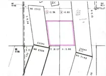
I am looking for help in describing a claim that I plan to stake. It consists of two government lots, but I don't want the whole of each lot, I want a total of 20 acres, where the combined lot acreage is 29.38, but I am only interested in the southernmost 20 acres to keep filing fees down. I have attached a portion of the MTP with the area I am looking to claim highlighted.

Would this need to be described by metes and bounds, or could I say that I am claiming the Southernmost 20 acres of the combined lot 3 and lot 9?

I realize that it would be easy enough to just claim both lots in their entirety and be done, but that puts me over 20 acres, and the north end of these lots is near vertical rock.
Claim location.webp
 
Upvote 0
from BLM website;
Placer claims must be described by aliquot parts and complete lots unless they meet one of these three exceptions:
  1. Located on unsurveyed Federal lands;
  2. Gulch or bench placer claims**; or
  3. Bounded by other mining claims or nonmineral lands
.
if the claim meets one of the exceptions, include a cover letter stating the exception. Also include a map of the claim. Describe the claim by metes and bounds.

** Gulch placer claim - placer claim located on the bed of a river contained within steep, nonmineral canyon walls. metes and bounds

** Bench placer claim - placer claim located on terraces or former floodplains made of gravel or sediment or both on the valley wall or slope above the current riverbed,
and created when the river previously was at a higher topographic level than now.

(hint) might have to buy a long tape measure - for a placer claim 20 acres is 1320' x 660'
 
Last edited:
Would your situation meet reason 3- nonmineral lands?
 
might look for a protracted survey its an odd shape, you may be better off just filling on the whole thing.
 
Last edited:
It's not a protracted survey. Lot 3 and Lot 9 are clearly shown with their acreage notation.

You could look up the patents if you are unsure of the boundary description. The patent numbers are at the bottom of the patent boundary. They might help you describe the metes and bounds.

If you need to know the status in more detail read the patent and survey and pull up the historical index at the General Land Office.

Heavy Pans
 
Don't you have to locate the whole lot anyway Clay? Or is it just ones that are more than 20 acres or irregular. Different type of "government lot" ? And labeled differently? Such as "L1 or L3". Is that just a BLM thing? I know to claim one near me I would need two locators, because it's over twenty acres and all of it has to be lacated at once.
 
An example of how to would write that would be..

South 10 Acres by area of Lot 3 and the South 10 acres by area of Lot 9. Totaling 20 acres.

I have worked with quite a few people on this in the past. I was baffled at first on how to write it. I call the Oregon BLM office and received an example. Also Oregon had all claims reviewed for this kind of thing about 3 years ago. There were quite a few people out there with claims describing something that didn't match the land survey.

Hope this help!
:-)
Sam
 
Last edited:
Sams description is what I would go with.

That being said, there are a couple of red flags for me that need to be clarified. You might have checked on these already. First the dotted line on the MTP typically surrounds lands that are "withdrawn from mineral entry" depending on the type of withdrawal this generally means no new claims can be filed. Second you mentioned that it is "government" land, if it is owned by the government no claims can be filed. Claims can only be filed on "public" land that is open to mineral entry.

hope this helps.
 
The dotted line is a PL359 withdrawl. It is forest service land, and I may have mistakenly identified a 'lot' as a 'government lot'.

edit: I called it a 'government lot' because that's what landmatters calls it when info is pulled up on a particular parcel.

When I first went to BLM to get information on staking a claim, I spoke with a very helpful fellow who worked there. I was showing him a MTP of an area I wanted to claim, which was a 'lot', with some corners of patented land encroaching into the southern portion of it. He told me that I could claim the south 1/2 of the lot, getting less than 20 acres, or that if I wanted the full 20 acre claim, I could claim the "southernmost 20 acres of X" lot, and get the whole 20 acres.
 
Last edited:
The dotted line is a PL359 withdrawl. It is forest service land, and I may have mistakenly identified a 'lot' as a 'government lot'.

When I first went to BLM to get information on staking a claim, I spoke with a very helpful fellow who worked there. I was showing him a MTP of an area I wanted to claim, which was a 'lot', with some corners of patented land encroaching into the southern portion of it. He told me that I could claim the south 1/2 of the lot, getting less than 20 acres, or that if I wanted the full 20 acre claim, I could claim the "southernmost 20 acres of X" lot, and get the whole 20 acres.

Good deal, sounds like you have got it all covered then, I just did not want you to waste your time and money filing the claim and then have them notifying you it was invalid. They take your money all day long. I don't know if you have done a PL359 before but it generally goes quick and painless, just have to wait the 60 or 90 days, what ever it is, and then you are all set.
 
I have done the PL359 before, I own a claim that will be adjacent to this claim, in the same power withdrawl. I looked for the patent docs, for the adjacent patented land, on the GLO website, but apparently, they have not been scanned into the system yet. I was going to go with Clay's suggestion and use the patent docs to help describe by metes and bounds. If I try to describe the claim as the south 10 acres of Lot three and the south 10 acres of lot nine, then, because of the near rhomboid shape of the claim, the northern border of each lot would not line up. I don't suppose there is any rule against describing it two ways? I would say I am claiming the southernmost 20 acres of Lots 3 and 9, and then proceed to describe by metes and bounds to the best of my ability.
 
Since the lots are surveyed, is it even acceptable to describe in metes and bounds? I'm not so sure about that. I'd go with Sam at Armadillos example.
 
Just make sure you use the "BY AREA" in the description. That part matters according to the BLM.
South 10 Acres by area of Lot 3 and the South 10 acres by area of Lot 9. Totaling 20 acres.

Otherwise, adding your metes and bounds on the location notice will verify your description.
For your piece of mind, will know your north most boundry. I do get why you want to describe it by M&B.
In my mind you then KNOW your exact borders. "By Area" is legal, but grey where the exact line is.
 
Last edited:
Thanks Sam. I guess, it really doesn't matter where my Northern boundary is, or that it's a segmented line if I describe as you say. The land on that northern border is near vertical for most if not all of it. That being said, I really don't even need the whole 20 acres, I could claim the southernmost 5 acres by area, of each lot and have all of the river I'm looking to claim. But, hey, you never know, maybe there's a vein waiting to be exposed on that northern border of the claim!
 
No Problem! Happy to help.

BUT!!!

You are paying for 20 acres no matter what!
So take as much as you can get. You are entitle to it.
 
On the other hand, what you haven't claimed isn't your responsibility...so if some yahoo digs it and makes a mess, it ain't your fault.
 

Users who are viewing this thread

Back
Top Bottom