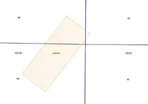
That can backfire on you arizau. The quarter section the BLM references the claim to may not be the area where the bulk of the claim is located. It can be a little hard to understand a wordy explanation of why this is so I made up a little graphic of this fairly common situation.
View attachment 1599324
This is an actual claim mapped in Arizona - one of hundreds that cross over Section and/or Township lines. You will notice that this now closed claim is across 3 sections (black lines) and two townships (blue lines). The entire claim is 600 feet X 1500 feet (20.66 acres). The largest part of the claim lies in 11N 1W Section 36. The second largest portion of the claim lies in the same Township but in Section 25. Just a little bit of the claim (about a quarter acre) lies in Township 11N 1E Section 30. Wanna guess which Township and Section the BLM references the claim to? Yep that smallest portion in the other Township is where the BLM will tell you the claim is located.

You would assume, if you are going by the BLM quarter section designation, that 11N 1E SW Section 30 was claimed and the other two sections were not.
There are at least a few 20 acre claims in Arizona that cover the corner of 4 Townships and 4 Sections. Only one of those 4 Townships and 4 Sections will be considered to be where the claim is located according to the BLM files. If you search the LR2000 for the other 3 Townships and Sections the result would show no claims there although the Serial Register page for each claim will show the different Sections and Townships.
The BLM is working to fix this problem but the results have been mixed so far so don't expect a reliable working system anytime real soon. From what I understand it's on the list of "fixes" but it's pretty far down that list.
One solution to the problem is to check all adjacent sections claims serial register pages. That takes a while but it can be very informative. I usually run a block of 9 Sections to check the claims placed by the BLM in any single section. That eliminates the possibility of missing crossovers and will give you a pretty good idea of groups that are claiming and the age of claims in the area, all good info to put in your research files before you spend time getting the County Location records for the claims in your area of interest.
If you are prospecting in most Arizona Counties you can get copies of the original location notices and maps as a free download online. It's an extra step that will reveal the errors that always seem to be a part of BLM case files as well as allowing you to know with some precision just what areas are claimed.
On the Land Matters
Mining Claim maps we've gone to a mapping system where a claim gets assigned to every Section it's found in. That requires a lot more server space and time to create but we hope it will help researchers. The example in the illustration above would be mapped to three sections and 2 Townships at Land Matters. Also a little misleading but a valuable heads up about claim crossovers to the clever researcher.

Heavy Pans
 .
. .
.


