Dateland, AZ

FWIW: The nearest 'mapped' RR Camp I could find around Dateland is Aztec.
 

Thanks John. I believe the maps you referenced are probably a bit old for when the stop was actually there. Some reading I have done indicated that there was a stop as that is where the soldiers would have departed to get to the Patton camps. Just trying to determine where it might have been. Also, it was just a stop and not a camp. The original Dateland is not where it is today, but about a block closer to the tracks that are there today. It would be nice to pinpoint where the actual passenger stop was. I would think there would have been a station building there if there was a stop just because of the shelter needed from the sun.
 

The picture that was posted might hold a clue. If you look in the background at the mountains, you might be able to take a print and try lining up on the mountains to get an approximate location.

There's a Book "Ghost Railroads of Central Arizona" John W. Sayre. I'm not sure if it has any info, but it's worth a shot.
 

I wonder if it's the tracks north of Dateland on Palomas Road. I have found a Horn Railroad Station reference....

More research is needed to see which set of RR tracks are the oldest.

I would think the tracks running parallel to I-8 are newer but what do I know?
 

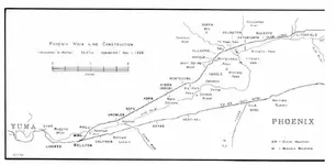
Horn and Hyder are both located along the tracks and can be viewed via google maps here:

32.976766, -113.434339

A friend of mine has the Employee Time Table for the RR during that time period that list all the stops. He said he would bring them over early next week. He did say that Hyder had a stop or siding withing the camp. With the amount of equipment that came to the Desert Training Center during the early 40's there had to be some sort of off loading spot for the Military outside of the public facilities.

Dateland, I believe was just a water stop, not an actual depot, but I'll be able to look at the official documents next week and possibly scan them to post here.

He's got a lot of history for the RRs that is very useful, including local history of this area, in talking with him, he said the majority of soldiers that passed through Horn and Hyder would take passes to Phoenix and also, the military pretty much took over Aqua Caliente as a "resort" for the officers..located here:

32.984976, -113.324213

regards,

Jim
 

That would be much appreciated Jim. The map location for Horn Station I ran across is about 1/2 way between the two camps. Makes sense to me that there was a military siding or station in that general area.
 

Hmmm

I will dig out my older 40's , 50's era maps of the AO and even ask some of the old guys at work if they recall any old stops there. When UPRR bought the SPRR line they made a point of tearing out most of the old SP marked water towers.
 

This past Sunday, I went down to the area an found what I believe to the the Horn station/siding. Map reference that I plugged into my GPS was about 100 feet off from where the actual water tower is. Foundations on both sides of the road along with lots of trash. On the south side of the road, there are piles and piles of one pint whiskey bottles - hundreds of unbroken ones laying around. Smaller piles on bottles on the North side of Palmas road.

32.9453, -113.5033
 

John,

The first pic a fuzzy scan of a 1926 map from the book RailRoads of Arizona Vol. II by David F. Myrick Howell-North 1980.

There is quite a bit of info on Hyder including the build up for WWII. As you can see from the map, the Hyder stop was originally called Agua and renamed on the RR time tables in the late 20's. I can post more scans if anyone desires, but it still leaves me wondering where exactly the Hyder station was located. From the text it appears all the WWII activity as far as transfering soldiers was done at the Hyder (Agua) station, close to the old Agua Caliente resort.

The second pic is just to prove there was actually a station there, this taken just before the build up.

Interesting note on the bottles at the Horn location...

BTW, I think the Lat in your post got fat fingered.
 

Attachments

  • hydermap.webp
    hydermap.webp
    34.9 KB · Views: 958
  • hyderstation.webp
    hyderstation.webp
    86.5 KB · Views: 676
Opps! Thanks for the heads up on my Lat/Long error - T'was only off a little bit!

32.9453, -113.5033

I love to see more scans or you could e-mail then to me ...
 

John,

The owner of the book mentioned above brought in Volumn 1 of the set...what an amazing amount if history. Unfortunately he grabbed Volumn 2 before I had a chance to re-scan the pages...the original scans were off center, I'll post one here and if you want I can e-mail the rest...sorry, they're messed up.

There's probably a total of 4 pages of text describing Hyder, the RR, the Army etc...but nothing definitive as to the location of the station.


Jim
 

Attachments

  • hyder2.webp
    hyder2.webp
    82 KB · Views: 603
What book/author is this?
 

It's called "RailRoads of Arizona" Vol. II by David F. Myrick Howell-North 1980. There's three volumes in the set, volume three is the most scarce. I guess the RR buffs have scooped these up and the now command a premium...my friend doesn't have Volumn 3 and I just saw it on Amazon for $175...
 

I ordered this book yesterday. Hopefully it will give some addition insite on Horn/Hyder. Found it on Amazon for around $22.00 plus shipping.

The Desert Training Center/California-Arizona Maneuver Area, 1942-1944: Historical and Archaeological Contexts (Technical)

Jim,
I'm almost positive the station is at 32.9453, -113.5033 based upon the foundations, water tower and dirt ramp(s) on the north side of the RR tracks. I plan on revisiting the area sometime in the New Year.
 

Wizzard, I think there was a WW 2 Japanese Internment camp between Yuma and Dateland? Just came through there last week, but did not have my detector......damn
 

I've heard or read somewhere of Italian POW's being held in that area ... I want to say in the Stoval area - can't remember .....
 

Top Member Reactions

Users who are viewing this thread

Back
Top Bottom