You can detect the beach above the water line all you want. You can't detect in the water even for modern jewelry in lease areas as it violates Florida law.
Just remember ignorance of the law is not an excuse, and can get you in trouble. It is your responsibility to be sure you are not in a lease area.
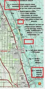
Here are the cords of lease areas.
BENT ANCHOR S32G 27.55.7N X 80.29.12W; East to 27.55.7N X 80.28.57W; South-southeast to 27.53.28N X 80.27.24W; West to 27.53.28N X 80.27.68W; then follow the mean low tide line to point of beginning.
CABIN WRECK S27 27.49.8N X 80.25.55W is the center point of a 3,000 yard radius excluding all land west of mean low tide line.
DOUGLAS BEACH S26 27.25.3N X 80.16.50W is the center point of a 3,000 yard radius excluding all land west of the mean low tide line.
POWER PLANT S25 27.21.2N X 80.13.65W is the center point of a 3,000 yard radius excluding all land west of the mean low tide line.
ANCHOR WRECK S23 27.48.2N X 80.24.70W is the center point of a 3,000 yard radius excluding all land west of the mean low tide line.
SPRING OF WHITBY S23 27.46.0N X 80.23.83W is the center point of a 3,000 yard radius excluding all land west of the mean low tide line.
RIO MAR S23 27.38.3N X 80.20.90W is the center point of a 3,000 yard radius excluding all land west of the mean low tide line.
SANDY POINT S23 27.35.8N X 80.19.65W is the center point of a 3,000 yard radius excluding all land west of the mean low tide line.
UNKNOWN S23 27.19.0N X 80.12.30W is the center point of a 3,000 yard radius excluding all land west of the mean low tide line.
CORRIGANS WRECK S25 27.46.2N X 80.22.67W is the center point of a 3,000 yard radius excluding all land west of the mean low tide line