Drones, anyone use a drone for metal detecting purposes

49er12

Bronze Member
Joined
Aug 22, 2013
Messages
1,302
Reaction score
1,705
Golden Thread
0
Location
Rolling Rock, Pennsylvania
Detector(s) used
Minelab xterra, Whites DFX, Notka Makro Simplex. Folks the price don’t mean everything, the question is are you willing to put in the time to learn the machine, experience will pay off I guarantee it.
Primary Interest:
All Treasure Hunting
yes, we use them for prospecting and detecting.. Easier to spot small clearings etc with new growth trees where homesteads and building might have been.
Plus allows us to fly into areas with what appears to be buildings on google maps, and confirm!
 

May I ask what type of drone and any particular maps that work best for you,I’m considering all factors
 

I have watched a prospecting video on here where they use a drone to scope out up river and I imagine it really helps with finding easier routes along jumbled boulders along a river to get to good spots or see if it is passable.
 

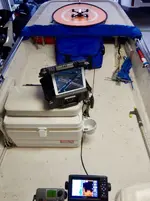
I use a GPS Drone in our travels. Fits in the palm of my hand or my shirt pocket when folded up. Sure beats bushwhacking through mangroves and heavy brush or hard to reach areas to check out potential locations. 4K video and still shots load right into my iPad. Push a button it takes off, push another button it “comes home” and lands, I can load in a route by bringing up google earth or topos on the iPad marking the waypoints by the touch of my finger, it will take off, fly the route at what altitude I want then return home and land. It also does “follow me” and will circle a location at any diameter and altitude you load in. One thing you have to watch if some of them get out of radio range they get lost and fly off to never never land. If you want to get a good laugh watch some of the best drone crashes on YouTube. If it is over a certain weight it has to be registered. Don’t even get me started on LiDAR.
 

Last edited:
469D585A-98EE-4A1D-B264-AC7D076D370B.webp
 

Nice setup looks like a Dji mini, you able to use iPad for viewing instead of phone, lightweight no registration required, thankyou
 

I use a GPS Drone in our travels. Fits in the palm of my hand or my shirt pocket when folded up. Sure beats bushwhacking through mangroves and heavy brush or hard to reach areas to check out potential locations. 4K video and still shots load right into my iPad. Push a button it takes off, push another button it “comes home” and lands, I can load in a route by bringing up google earth or topos on the iPad marking the waypoints by the touch of my finger, it will take off, fly the route at what altitude I want then return home and land. It also does “follow me” and will circle a location at any diameter and altitude you load in. One thing you have to watch if some of them get out of radio range they get lost and fly off to never never land. If you want to get a good laugh watch some of the best drone crashes on YouTube. If it is over a certain weight it has to be registered. Don’t even get me started on LiDAR.

I love LIDAR !
dts
 

I like Gaia premium mapping, dozens of overlays and Google Earth. The case the iPad is in, incorporates a Garmin GLOll gps for the pad and a Verizon hot spot for Internet so all mapping is in real-time and live drone video feed. The case also has a 26800mAh battery pack for portable use or connects to any accessory jack. The Chartplotter/Sonar in the Skiff has the CHIRP sonar technology, super impressive! It’s like looking at 3D, bottom resolution and detail is unbelievable.
 

Just curious anyone scope out new places via air, drones can be helpful flying and viewing at home. It’s definitely a different perspective looking at things from the air. Yes I no there’s google earth or whatever, but you can get real time views of woods, lakes etc. I’m sure someone uses them , tell me about your experience, thanks

I used Talos Drones named as DJI Phantom 4 RTK but it's tempting if you're on a big field and want to spot bricks and such without walking 5 miles.
 

Last edited by a moderator:
Just curious anyone scope out new places via air, drones can be helpful flying and viewing at home. It’s definitely a different perspective looking at things from the air. Yes I no there’s google earth or whatever, but you can get real time views of woods, lakes etc. I’m sure someone uses them , tell me about your experience, thanks.

I have watched a prospecting video on here where they use a drone to scope out up river and I imagine it really helps with finding easier routes along jumbled boulders along a river to get to good spots or see if it is passable.
 

Nope, but I have found 2 in the woods while metal detecting.
 

I could see a drone helping to find an old homesite if it's still somewhat standing and intact.
Video quality of drones sucks bad and they dont work well for small or specific targets, only big stuff.
My son buys and sells alot of drones and they are kind of a toy.
 

Top Member Reactions

Users who are viewing this thread

Back
Top Bottom