You are using an out of date browser. It may not display this or other websites correctly.
You should upgrade or use an alternative browser.
You should upgrade or use an alternative browser.
Fort Huger, Battle of Mobile Bay
- Thread starter MichaelB
- Start date


Leon
Silver Member
Nope,,, I tried looking, but it said the file was empty. It went into google but could not find a location...
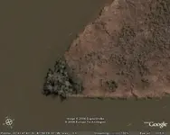
Is that where two rivers are joining together?
You might try saving the file again and re-posting it...
You can use the modify tab on the original post to re-attach the link...
Is that where two rivers are joining together?
You might try saving the file again and re-posting it...
You can use the modify tab on the original post to re-attach the link...
cptbil
Bronze Member
Micheal:
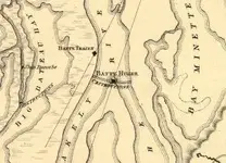
I have a Civil War Map, of Mobile Bay, that shows, where, two Iron Clad Ships are located (SUNK) !
Interested ?
I have a Civil War Map, of Mobile Bay, that shows, where, two Iron Clad Ships are located (SUNK) !
Interested ?
cptbil
Bronze Member
MichaelB:
Do you intend to salvage/dive on the sites ?
Do you intend to salvage/dive on the sites ?

cptbild
Sr. Member
- Joined
- Oct 3, 2005
- Messages
- 339
- Reaction score
- 11
- Golden Thread
- 0
- Location
- NM/AZ/CA/Co/Utah & P.I. Tx.
MichaelB:
No!
I should have been more specific !
I didn't mean, the "River" site, that you were talking about !
I meant,
If I send you the Map of the "Two Iron Clads", and "It", the "location/site",
is in the upper portion of Mobile Bay!
Are you planning to DIVE/Salvage THAT SITE!
No!
I should have been more specific !
I didn't mean, the "River" site, that you were talking about !
I meant,
If I send you the Map of the "Two Iron Clads", and "It", the "location/site",
is in the upper portion of Mobile Bay!
Are you planning to DIVE/Salvage THAT SITE!
birdman
Gold Member
- Joined
- Jan 28, 2005
- Messages
- 7,458
- Reaction score
- 2,394
- Golden Thread
- 1
- Location
- Choctaw Beach Florida
- 🥇 Banner finds
- 1
- 🏆 Honorable Mentions:
- 1
- Detector(s) used
- Equinox 800 and ORX, tesoro Cibola with garret,whites and minelab pinpointers
- Primary Interest:
- All Treasure Hunting
That part is extreamly muddy and is infested with gators. I would think those ships are very deep in the mud. It would take a lot of loot and lots of legal paper work for that to come to light. It would be a grand adventure though. I have hunted on land not far from there in old Blakley. It's all federal or private property now.
I would think those ships are very deep in the mud. It would take a lot of loot and lots of legal paper work for that to come to light. It would be a grand adventure though. I have hunted on land not far from there in old Blakley. It's all federal or private property now.pcolaboy
Hero Member
- Joined
- Sep 5, 2006
- Messages
- 916
- Reaction score
- 14
- Golden Thread
- 0
- Location
- Pensacola, Fl
- Detector(s) used
- Minelab Explorer XS
I live in Pensacola, FL only 50 miles away and I would be interested in going down to check the area. I've been diving within plain site of gators without any problems and would be willing to do it again.
I have a boat as well by the way but I'm not familiar with the waters that far up the river - MichaelB would you want to go along for the ride and be the gator lookout?
Pcolaboy
I have a boat as well by the way but I'm not familiar with the waters that far up the river - MichaelB would you want to go along for the ride and be the gator lookout?
Pcolaboy
birdman
Gold Member
- Joined
- Jan 28, 2005
- Messages
- 7,458
- Reaction score
- 2,394
- Golden Thread
- 1
- Location
- Choctaw Beach Florida
- 🥇 Banner finds
- 1
- 🏆 Honorable Mentions:
- 1
- Detector(s) used
- Equinox 800 and ORX, tesoro Cibola with garret,whites and minelab pinpointers
- Primary Interest:
- All Treasure Hunting
Man,I wish there was a way that I could tag along. Sounds like high adventure to me.
Sounds like high adventure to me.
C
cowboyjake
Guest
I am very interested. What do you need and when do we startcptbil said:Micheal:
I have a Civil War Map, of Mobile Bay, that shows, where, two Iron Clad Ships are located (SUNK) !
Interested ?

cptbil
Bronze Member
"Cptbil" Can come up with a map showing the locations!
But!
Why would "Cptbil" want to give away his research?")
Perhaps you don't realize,
BUT!
In TH'ing ....
GoodResearch = PossibleLocation = HopefullyRecovery = Money in pocketFinancial gain!
A TH'er/person doesn't just GIVE AWAY Treasure locations! :P
But!
Why would "Cptbil" want to give away his research?
Perhaps you don't realize,
BUT!
In TH'ing ....
GoodResearch = PossibleLocation = HopefullyRecovery = Money in pocketFinancial gain!
A TH'er/person doesn't just GIVE AWAY Treasure locations! :P
cptbil
Bronze Member
One more thing,
As you know, you need to have equipment !
The river is 1/2 water, 1/2 silt ! :P
Meaning, you'll need something, like an, u/w detector (boat towable) or!
A "mag" (u/w magnetometer) to find the location!
The map was drawn in the Civil War days, and that means, it's not going to be an exact
GPS location!
Do you have or can you obtain this ?
pcolaboy
Hero Member
- Joined
- Sep 5, 2006
- Messages
- 916
- Reaction score
- 14
- Golden Thread
- 0
- Location
- Pensacola, Fl
- Detector(s) used
- Minelab Explorer XS
Sorry I haven't checked in on this thread in a while.
Another forum member that lives near this location told me that there was a guy who was recovering cannon balls from this site 10-15 years ago.
Apparently he got the govt's attention by selling them and a sting operation ensued landing him in jail and/or a stiff fine.
I'm still game though!!!
Pcolaboy
birdman
Gold Member
- Joined
- Jan 28, 2005
- Messages
- 7,458
- Reaction score
- 2,394
- Golden Thread
- 1
- Location
- Choctaw Beach Florida
- 🥇 Banner finds
- 1
- 🏆 Honorable Mentions:
- 1
- Detector(s) used
- Equinox 800 and ORX, tesoro Cibola with garret,whites and minelab pinpointers
- Primary Interest:
- All Treasure Hunting
I remember that very well! The Gov. set up a sting and got him and he was ruined. He was the owner of search scan detectors in Fair Hope Al.
Top Member Reactions
-
 2285
2285 -
 1423
1423 -
 1387
1387 -
 1371
1371 -
 1116
1116 -
 950
950 -
 822
822 -
 770
770 -
 692
692 -
 586
586 -
 538
538 -
 519
519 -
 518
518 -
 467
467 -
 453
453
Similar threads
- Replies
- 3
- Views
- 242
Users who are viewing this thread
Total: 1 (members: 0, guests: 1)
