Geology questions

Here in the Sierras of California I've read that this material can be the bottoms of ancient river beds that flowed in the time of the dinosaurs. Over time, erosion, and volcanic activity they were buried deep enough that the pressures caused the stuff to become a hard pack cobble. Hydrolic mining with large water guns helped to break it up...
 

Thanks for the responses,
Clay apparently is weathered rock but the article does not explain the geologic processes that create an entire creek bottom 4-5 feet thick and deeper.
Also the article on cementation states that it takes millions of years but our cemented cobble is Definately glacial as that is where out gold is usually locked up in. Our glaciers occurred 10 and 29 thousand years ago which from what I understand is why there is gold here ( brought by glacial activity ).

Although I appreciate the effort in your responses I feel no closer to an answer. It's funny that the thing we are all looking for ( ie: clay bottoms, cemented cobbles, bedrock ) we seem not to have any idea how they occur.
I am inquisitive by nature and feel that knowing how they form gives me a better understanding of the natural world around me and also in my prospecting hobby which I love so much.
Thanks again
 

I found this small explanation of how clay is formed:
[h=1]clay[/h]
[h=2]Formation[/h] Clays are divided into two classes: residual clay, found in the place of origin, and transported clay, also known as sedimentary clay, removed from the place of origin by an agent of erosion and deposited in a new and possibly distant position. Residual clays are most commonly formed by surface weathering, which gives rise to clay in three ways—by the chemical decomposition of rocks, such as granite, containing silica and alumina; by the solution of rocks, such as limestone, containing clayey impurities, which, being insoluble, are deposited as clay; and by the disintegration and solution of shale. One of the commonest processes of clay formation is the chemical decomposition of feldspar.
Clay consists of a sheet of interconnected silicates combined with a second sheetlike grouping of metallic atoms, oxygen, and hydroxyl, forming a two-layer mineral such as kaolinite. Sometimes the latter sheetlike structure is found sandwiched between two silica sheets, forming a three-layer mineral such as vermiculite. In the lithification process, compacted clay layers can be transformed into shale. Under the intense heat and pressure that may develop in the layers, the shale can be metamorphosed into slate.

Read more: clay: Formation | Infoplease.com clay: Formation | Infoplease.com

Caliche is a false bedrock that is formed by the mixture of clay, sand, calcium carbonate from dissolved limestone, sodium chloride, and sodium nitrate. Caliche usually forms in semi-arid regions. If caliche binds cobble, there may be gold in the spaces the caliche fills between the rocks. I mine a place like that in Utah. The caliche false bedrock in Arizona doesn't hold any gold, and very little gravel. It was deposited and hardened before the gold bearing gravels were deposited over it.

The thickness of the deposit depends on the size of the flood or stream that deposited the material. In the case of the deep beds you mentioned, I imagine there may be several layers, but it's not impossible for a flood to deposit a five foot thick bed. It just means that there was some strong erosional processes to break down the rocks the clay was formed from before a huge flood moved it to a new location. It may be that the clay you are talking about could have been deposited there as residual clay from rocks that are now gone, but I lean toward it being transported there from a flood. Since glaciation took place there, it may be that the clay was formed from eroded granitic rocks, and moved by glacial melt which may have caused the stream you are talking about.
 

Excellent answer, thank you
I lean twards decomposing sedimentary limestone that was placed all at once but it's impossible to know.
I guess that because there is broken slabs everywhere and if you lift a sheet that clay is what you find.
It's all the same consistency, color, and has the same tiny minerals conglomerates no matter where you check and no matter how deep. Just a series of guesses though.
I do appreciate the responses and your answer tonto
 

Found old piece of weathered granite big enough to fill 2, 5 gallon buckets. Loads of mica in it. Only have 1 bucket left full of the material that's weathered enough I can break it by hand. Would u crush it and pan it? Or toss it like the other bucket?
 

Last edited:
I'm not a geologist, but I have studied a little. Mica forms at lower temperatures than gold, so if mica is present in the amount you have described in the sample, the chances of gold are slim, unless the gold was already there when the mica bearing rock cooled down. That doesn't seem right to me. I have found samples like you describe, and have never found even a speck of gold.
 

Basically the glaciers brought down material as the ice flow came south. Once the glaciers stopped advancing and started melting the lakes and rivers formed from the water running off the glaciers and through the material the glacier pushed. This drainage allowed the materials to be sorted by this water. Over millions of years large rivers and lakes formed layers that are found today. The advance and retreat cycle of the glaciers caused lots of different layers to be formed.

The link below is from a source that explains it better than I can,


Hope it helps.


outwash plains
 

Caliche is one of those "good and bad" things. Formed mostly by calcium carbonate, it can be a real PAIN to get through. But then, in gold bearing areas, it also means no one has been under it! Might be worth checking it out! TTC


Caliche is a false bedrock that is formed by the mixture of clay, sand, calcium carbonate from dissolved limestone, sodium chloride, and sodium nitrate. Caliche usually forms in semi-arid regions. If caliche binds cobble, there may be gold in the spaces the caliche fills between the rocks. I mine a place like that in Utah.
The caliche false bedrock in Arizona doesn't hold any gold, and very little gravel. It was deposited and hardened before the gold bearing gravels were deposited over it.


I suppose caliche and cemented gravels are not the same animals then.

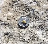
I found this small gold nugget last fall imbedded in cemented gravels near Quartzite AZ.
Had to use a hammer and chisel to get to it. found it by using a metal detector.
quartzsite fetus nugget.webp


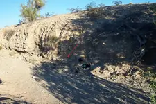
The red arrow points to where it was found near the bottom of a wall of cemented gravels that a wash had cut through the edge of.
Keep clicking on the photo to zoom in.
caliche wall.webp


GG~
 

Last edited:
Time to take that whole bank out GT!
 

Time to take that whole bank out GG!

Took more than an hour just to go a few inches with a hammer and chisel.
That bank would need several lbs. of C4. Then a heck of a crusher. :tongue3:

impact-crusher-1.webp
 

Last edited:
What amazes me about the gravel deposited by the melting glaciers, is not just the amazing volume of material, but the layers are not level as you would expect with water deposited material.

I have worked in a Gravel pit in central Ohio, and some of the gravel/sand layers are laid at a 30 degree angle or more.

It has to do with deposits on top of ice, that melted and tipped the material......I guess. It really looks odd to see dozens of perfectly flat layers, lying at an angle.
 

That nugget looks to be placer in nature .

Makes sense, since it was found in an ancient placer :icon_thumleft:

Placer deposits form at Earth's surface when weathering action exposes gold from other, older lode deposits. The gold is swept into, and settles in, streams, lakes, rivers or the sea floor. Many placer deposits are of recent geologic age, but some are billions of years old.
 

Last edited:
I suppose caliche and cemented gravels are not the same animals then.

I found this small gold nugget last fall imbedded in cemented gravels near Quartzite AZ.
Had to use a hammer and chisel to get to it. found it by using a metal detector.
View attachment 1043474


The red arrow points to where it was found near the bottom of a wall of cemented gravels that a wash had cut through the edge of.
Keep clicking on the photo to zoom in.
View attachment 1043475


GG~
I just re-read your post (and zoomed in on gravels pic). Tip: When working the sides of embankments, take the coil off and hold it in your right (you are right handed, right?) hand to get much better control and quicker pinpointing ability. TTC
 

Hey Terry, thanks for the good tip. I sometimes think I'm as dense as a rock. What a good idea which has never occurred to me.

Mike
 

Top Member Reactions

Users who are viewing this thread

Back
Top Bottom