As a professional cartographer I can guarantee you there is no such thing as 1 foot accuracy available unless you are employing a very expensive surveyor using the latest equipment for a site specific, on the ground, survey.
I could go on to explain the differences between accuracy, resolution and precision but why bore folks that really don't care?
Here's the meat in terms of public use of the word accuracy:
Aerial photography at it's best will be accurate to 9 foot. You aren't working with 9 foot accuracy (see below).
Public land surveys as presented on the internet - including county assessors maps will be accurate to 9 foot at best. The ones on Google aren't 9 foot accurate. Most public land surveys don't actually exist - they are extrapolations from an real survey pin that may be many miles away. Error in those many cases goes way up.
Topo maps are accurate to 40 foot at best. Often much less.
"Commercial" GPS units are 98% accurate to 30 foot (Commercial units are the ones you are using hand held in the field). With WAAS enabled and an 11 satellite lock in the dry southwest air with no trees or clouds and 4 minutes of static settle time GPS can be 9 foot accurate 98% of the time. Go north, damp air, no settle time, trees, clouds - not so much.
Now let's add in Google images to the equation. To find out how accurate Google maps are we need to go to the source. Google itself has already cleared this up for us. Direct from Google:
"How accurate is Google Earth mapping?
Google makes no claims as to the accuracy of the coordinates in Google Earth. These are provided for entertainment only and should not be used for any navigational or other purpose requiring any accuracy whatsoever.
Our imagery varies from sub-meter resolution in major cities to 15 meter resolution for most of the earth's surface, with a global base resolution of 1KM. Since our database is constantly being updated, we cannot state a specific resolution for any geographic region.
Google acquires imagery from many different sources with many different file formats, projections and spectral characteristics. All imagery sources are fused into a single global database with a proprietary format that has been developed for the specific purpose of streaming to our client software."
Seems Google doesn't make any claims to accuracy at all. "Entertainment only" pretty much sums up the Google Earth map philosophy. If you understood how Google makes their maps you would understand why they won't consider them to be any more than entertainment.
Now lets add all these errors up and realize that if the best aerials are 9 foot off in one direction and the GPS is off 30 foot in another direction and the PLSS is off 40 foot in another direction and Google doesn't know where it is - do I need to draw you a map?

There is a lot to this mapping stuff that the public doesn't see. There is a huge amount of politics involved in marking ones territory. Seldom do the County Assessor and the USGS agree on where a property line is. Many neighbors can't agree on where a 100 foot property line is so don't expect accuracy on a map to be better than on the ground.
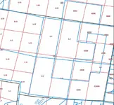
Here's a real world example of the difference between the PLSS and the County Assessors maps in a random section on the American River. I could show you many many more of these from virtually anywhere in the US. Many are much worse. In this map the black lines are the PLSS Sections the red are the aliquots and lots and the blue lines are where the County Assessor thinks the survey lines are. Their disagreement varies from a few feet to several hundred feet.

So if the County Assessor and the official USGS survey can't agree... accuracy?

I deal with these issues every day. I can guarantee you I make some of the most accurate maps available. My goal is one foot accuracy and I will honestly say the closest I've ever come to that standard across an entire map is about 30 foot. Sure I can show you where a single survey pin, GPS and my map all agree within 9 inches but a whole map? Not a chance. Not a chance for me, Google or the County Assessor. If a map is off 30 foot in any single place the real accuracy of that map is only 30 foot - not the 9 inches accuracy found in one spot.
Think of it this way. A really good painter paints a picture of your friend. You look at the painting and say to yourself "that looks just like my friend". But is it just like your friend? Could you use the picture to take to a doctor and get a diagnosis? Could you send the painting to a court to represent your friend? Could the painting move in with you and do the dishes and pay the rent?
The painting is not the same as your friend. A map is not the same as your position on the ground. You can't trust your health, property or human relationships to either a painting or a map.
Maps are incredibly useful if you understand their limitations. I love maps and mapping but I'm always acutely aware of their limitations. Get the best maps you can and use them to get you where you need to go. Once you are where you are going the facts on the ground trump even the best of maps. If you want to know where you are look around you.

Heavy Pans


