What's new

google earth images

New Orleans Relic

Sr. Member
Joined
Jul 17, 2012
Messages
435
Reaction score
132
Golden Thread
0
Location
New Orleans burb
Detector(s) used
At-Pro, Fisher F2
Primary Interest:
All Treasure Hunting
How can you tell when images on google earth were taken? I've wandered when they updated. I've seen pics there with boats on the road from hurricane Katrina. With all the storms the gulf coast has endured in the last 8 years, I need to zoom in on at least annual images.
 
New Orleans Relic said:
So no one has any thoughts?

I have lots of thoughts. Some good some not so good and many In between.


Try Bing.
 
HAve you ever looked at anything other than the picture itself? When you load a google earth image it has a lot of other info with it. You can scroll through past pictures of the same spot (with thier dates also)
 
Jason in Enid said:
HAve you ever looked at anything other than the picture itself? When you load a google earth image it has a lot of other info with it. You can scroll through past pictures of the same spot (with thier dates also)

How to do? I'm looking at a GE image right now, but don't see options to scroll to older images. Possibly I have to boot up the desktop computer. I'm on this little iPad right now.

M
 
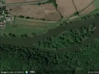
Look in the lower left of the Google Earth image. It has an imagery date.
-Swartzie
 

Attachments

  • 2012-08-18_091049.webp
    2012-08-18_091049.webp
    40.5 KB · Views: 175
Swartzie said:
Look in the lower left of the Google Earth image. It has an imagery date.
-Swartzie

I see it on your attached photo. Little iPad app for GE does not seem to have it. Will switch to a real computer because I want to work back in time a few years if that is possible. Is that accomplished by clicking on the date in the lower left?

Thanks .....

M
 
Last edited:
Yep,
Depending on the photos available, it will open a box top left and you can scroll through the previous years.
HH
Steve
 
Ray, I heard that Google has been updating at least some of the imagery here in town lately, I haven't looked into it much yet but I'm hoping for new images of a few areas I want to look into.
 
Having previewed prospecting areas from GE, and then actually went to those locations, GE has a LOT of shortcomings. Many areas of the national forest have very low resolution photos to view. Why is that exactly in the year 2012? That is why I am working on a way to create my own aerial maps that have much better resolution, and are simly not subject to the whims of Google...
 
UncleMatt said:
... I am working on a way to create my own aerial maps that have much better resolution, and are simly not subject to the whims of Google...

Matt ... are you planning on doing a mosaic from low level aerial shots? Prior to satellite imagery the government contracted out for that work, but not much is going on now.
Which means the available aerial photos may not be current. Not that out of date is a downside since what you are seeking may be shown on older photos and not on current satellite passes.

M
 
Last edited:

Users who are viewing this thread

Back
Top Bottom