Now I do have a concern with something related to mylandmatters and the database being used for Earthpoint Townships (and the BLM).
When you look at mylandmatters maps there are Government Lots still being listed that were taken out of the Master Title Plat almost 40 years ago.
Earthpoint Township doesn't show these outdated Government Lots 1 only the Lots that are currently in place.
I was wondering why mylandmatters shows 2 "Lot 1's" out in Rye Patch (T32N R32E Section 18) and Earthpoint does not.
Not a slam on mylandmatters by any stretch.
Again it's been 40 years since those Lot 1's existed and I prefer to see the latest database that corrects for changes to the Master Title Plat?
Any help appreciated.
I'm sorry I didn't see this before Dawg. I have an explanation for you but I'm not sure I can give you an answer.
The
Earth Point PLSS appears to be the CadNSDI V1 as I pointed out before. The V1 was closed to changes in 2015, that data is static and will not be updated. The mapping for your section of interest is
current to 2015
The
Land Matters PLSS is the CadNSDI V2. The V2 is being updated virtually every month somewhere in the United States. The data changes. Nevada was last
updated in May of 2017.
That's why the two maps don't agree. Different data with different dates. Neither one are the answer to your specific question but it does establish that the Land Matters data is the more current of the two.
So who's right?
I can't give you the answer but I can give you the tools to find out for yourself. It might take a while but the answers are available.
Here's what I
found:
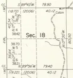
The MTP doesn't show Government Lots in that east half of the west half.
The multiple surveys only show two 80 acre strips occupying the North and South of that area.
There is no indication of quarter quarters being protracted in that area.
Here is the section shown in the most recent survey from 1978.

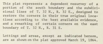
The scope of the survey and a pointer to the 1864 survey as authority for the subdivisions portion of the survey.

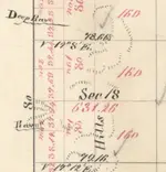
The 1864 survey

All those seem to indicate that the area was never designated as a lot and was never surveyed for quarter quarters.
That would make the Land Matters PLSS wrong.
The problem is if that strip isn't broken down as quarter quarters on any map and it isn't designated a Government Lot what the heck is going on?
The place to find the details as to why a survey is made one way or another is to read the Survey Field Notes. Those will tell you why that area is so wacky.
Here link to the
survey field notes for your area of interest. These field notes can be very revealing. They don't just have notes about pins and distances but they have a running description of the land and how it was being used. These handwritten notebooks can be difficult to navigate and a little confusing but I would suggest looking them over very carefully. I did a quick look and there are some pretty good notes on your area. Don't get so buried in reading about who lived where and where there were minerals being mined that you forget to look at the instructions for the survey. *wink* wink hint hint.
You think that the "Lot" designation was removed at some point but there is another possibility I'm guessing you hadn't considered - the land is still unsurveyed.
Looking at the documentation for the PLSS doesn't show any protracted survey in that Township. The entire Township has been surveyed including government lots and aliquots. That's why they assumed the strip was a government Lot. I think they may be wrong because I think I saw something in those survey field notes about instructions not to survey particular 80 acre strips. *wink ahh!*
On unsurveyed unprotracted lands you can claim by a logical regular unofficial protraction or metes and bounds. I usually locate all claims by both no matter which type of claim but set the lead page for the aliquot description for placers.
So who's right? I think I would go a little further and see why the cadastral survey now considers those strips to be lots and why the BLM doesn't. Armed with the information from your search that should be an interesting conversation. The answer you get there would answer your question ...maybe. I'll let you take it from here.

I do this type of research quite a bit. As you are beginning to understand land status can get pretty complex. I can tell you from experience that these types of information conflicts are
very common. If you are going to locate claims you should be aware of potential conflicts before you locate. As you found corrections made later are painful.
Your continued support is much appreciated and your feedback on this issue and others is important information to help Land Matters bring you the information you need. Land Matters is working on tools to allow you to download all these documents directly from a map. Just trying to make all this a little easier.

Heavy Pans


