H E L P !

jeff of pa

Super Moderator
⛭ Moderator
🥇 Charter Member
Joined
Dec 19, 2003
Messages
90,031
Reaction score
65,648
Golden Thread
2
🥇 Banner finds
1
🏆 Honorable Mentions:
1
Primary Interest:
All Treasure Hunting
I am trying to Find a Creek here in pa.

I have a PA STREAMS MAP that is supposed to show Every Stream, creek, river, & body of water in Existence here.

Guess What. "Deckers Creek" isn't

The GPAA lists it at :

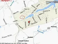
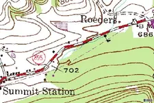
40 Degrees 35' N / 76 Degrees 12' W

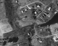
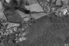
near SUMMIT STATION, Schuylkill County, off PA rt. 183

Does anyone Know how to us these Cordinates, to find this Creek on a Map site, on the Net ?

I could just Go out there (15 Min. from me) & ask , but , IF I can find it, I don't have to risk having to ask Everyone & Their Brother, till I find someone who actually Knows :D

THANKS in Advance
Jeff
 

WOW, the Cordinates took me right to an Intersection.

THANKS ALOT, Yurt_Boy :)

I'll post tomorrow If I found it.

Jeff
 

Right on! I found that site by way of my buddy's site, www.iInvestigate.net. He's got several map/satellite photo pages. That was just the first one I tried. Good luck!
 

i'm using a form of terra client,but i dont remember which one.
its saying its 4 km SW of lake wynonah.looks like a bridge then the creek splits.
 

hope this helps jeff
wing
 

Attachments

  • tg.webp
    tg.webp
    18.7 KB · Views: 372
YEA THANKS.

in my COUNTY ATLAS,

There Is also "FAWN LAKE" right between there & "Lake Wynonah"

Unfortunately IF it's ON Lake Wynonah Property, I'm probably Out of Luck.

This Is a Gated Community With Guards at the Gate. http://www.lakewynonah.com/

they only let the Public in when they have their annual Community Yard Sale, & then you are Givin Strict Orders to Stay in the areas Designated.

of Course the Creek has to run somewhere, So I may have to Go Down or Up Stream.

? ? ?Jeff
 

Yea It appears to be within the Community.

I circled where the Cordinates took Me.

of course the Tributaries around there are worth a try.
 

Attachments

  • untitled.webp
    untitled.webp
    25.7 KB · Views: 355
Jeff, I got these coordinates from a military site, but could not find a map that shows the creek:

40.5639805 N -76.2043907 W but these are the best our taxes provide! ;)
 

Omni,

Was that for the The Creek or Summit Station ?

The Cordinates deinately Place me Closer to Bear Cr. at Summit station.

Which Would make the Site accessible to me.
 

jeff,, you might check on this in your state......here the waterways, creeks, rivers, are considered state or public domain,, even if the property around them is privately owned.....cemetarys are the same, and you can not be stopped from being there.........gldhntr
 

jeff of pa said:
Omni,

Was that for the The Creek or Summit Station ?

The Cordinates deinately Place me Closer to Bear Cr. at Summit station.

Which Would make the Site accessible to me.

They were for Deckers "stream", here is a topo and aerial photo:
 

Attachments

  • download.webp
    download.webp
    49.5 KB · Views: 323
  • download2.webp
    download2.webp
    33.5 KB · Views: 311
Great.

Thanks Omni.

Weather Cleared Up enough to Run out for a Half hour this Morning.

Didn't Hit the Right Creek.

Nobody out there I talked to heard of it either :(

Didn't really Matter tho.

The HEAVY rains we'v been having , have the water Rushing too Fast right now.

I didn't feel like fighting with the currents.

Was Fun looking around tho'

& at least now I know what Creek. ;)

THANKS AGAIN
Jeff.
 

Jeff, try this link. You can search by way of many different parameters. It's use it to locate all kinds of old places to hunt on. Hope it helps.

PS - I went to my state and did a general; search and downloaded over 5000 sites ;D! Cut and paste them into MS Excel.

Wallycoz
 

Top Member Reactions

Users who are viewing this thread

Back
Top Bottom