Just want to put this question to bed once and for all, as so far no one has got the answer exactly correct. Your symbol, as you'll soon see, is actually not a symbol at all.
Before I explain that, there are two things you should know about the image you posted. First, the top half and the bottom half are actually segments of two completely different maps. That is why you see the weird visual effect across the center of the image where the contour lines appear have an abrupt change in width. Second, swmomark is correct in that purple markings represent revisions made to previously published maps. Therefore, taking a look at the previous map can help us solve the mystery surrounding your symbol. The following image should tie all the information together.

The "before" section of the image is the area of the map in question in the revision prior to the one you looked at. The legend below explains what exactly is passing through the "pyramid" before it existed: a water feature called a "narrow wash".
In the revision (the map you posted) depicted in the "after" section of the image, we see the purple "symbol" in that spot where the narrow wash runs through. I can see how one might mistake it for other triangular shaped symbols -- like a benchmark, for example. At a small level of magnification, it sort of does look triangular. However, the higher level of magnification to the right shows that the area actually isn't triangular. Rather, it seems to follow the elevation contour surrounding it (i.e., we are looking at some kind of natural feature). Knowing that it is not a "triangle", but an outline, along with the fact that water runs through it, leads us to the answer, which you see in the legend below: it is what as known as an "intermittent pond" -- one that is sometimes filled with water from the narrow wash, and sometimes not. The dashed purple lines you see below it represent a new "unimproved road" just to the south (that is, a dirt path). With all this in mind, we can use modern satellite imagery to verify the explanation.

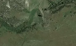
What you see here is a recent satellite photo of that same area you asked about. Note how a very narrow flow of water seems to intersect a roughly triangular perimeter of ground, and the border of shrubs and trees around the east and south edges of that triangle. This is what explains your symbol. When there is a lot of water flowing through the narrow wash, it spills over into the triangular area, which is an "intermittent pond". When there isn't a lot of water flowing, it travels around the southeast corner of that intermittent pond instead, allowing vegetation to spring up. That is what we see in this picture: there isn't enough water at the moment, so the pond has dried up. Someday, when the narrow wash has higher flow, the pond will reappear -- hence its labeling as "intermittent". Finally, you can see the dirt path (i.e., the "unimproved road") that travels south of the intermittent pond. This should allow you to verify that the pictures I've posted are indeed of the location you were asking about.


