Hurricane Peak

Jjhall68

Full Member
Joined
Jun 23, 2014
Messages
112
Reaction score
90
Golden Thread
0
Location
NW Washington
Detector(s) used
Bazooka Gold Trap 30" Prospector heavy weight, Gold Cube, Blue bowl, Garrett, 2" Keene dredge.
Primary Interest:
Prospecting
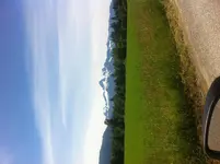
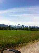
I am new to the forum but thought I would share this picture I took on the way to do some scouting for a new prospecting spot. That is hurricane Peak in the foreground and the Juggernaught to the left. This is the North Cascade range in NW Washington. I hope this works. image.webp

All the Best,
John
 
Hurricane Peak is near the town of Darrington, Wa that picture was taken in in a place called Sauk Valley. I don't have the words to describe the area it's the confluence of Sauk and Suattle river both drain Glacier Peak (one of the cascade volcanos) from the end of the valley you can hike up Valley Mountain to get a look at a view that will stick with you along time. Try doing a google earth fly by on Glacier Peak. The area is rich in mining and logging history and trails, river rafting, biking hiking, you name it outdoors. If you have an interest I can help with I would be happy to point you in the right direction, this time of year I do a lot of no.2 shovel work and give great lessons.

Good luck,
John
 
photo_picture.gif
Nice photograph John (even on its side)! Thanks for sharing...
 
Thanks I like it, could anyone tell me how to keep it from being on its side? If you klick it, it comes up right. I'm new to this forum and not sure what I did wrong.
 
Thanks I like it, could anyone tell me how to keep it from being on its side?
If you klick it, it comes up right. I'm new to this forum and not sure what I did wrong.

John, I downloaded your pic and turned it straight. Not sure
why the sites program does this, but all you need to do is
open the pic in Microsoft Office Pic Mgr. (or Paint, etc.) and
rotate it to the proper position, then post.

image.webp

I know that spot....well!
 

Users who are viewing this thread

Back
Top Bottom