Gypsy Heart
Gold Member
- #1
Thread Owner
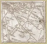
In 1788, only three villages, Lee’s Town, Lebanon and Woodford are shown on the first map to show the outline of the first Woodford County, and later the same three villages are shown on the J. Russell 1794 map of Kentucky following its reduced size. Today none of these three villages exist as a town.
A few sections of old rock walls, which were part of the Woodford Village flat boat launching site, exist today, pinpointing the exact location. The name of this village appears on early correspondence of old letters, as Woodford Village, and finally Woodford shipping port. The port when it was in use was located on Fishers Mill Road, on the Southside of the bridge which crosses over Elkhorn Creek. The road is approximately one mile west of the town of Midway, on U.S. 421.
It is believed that David C. Humpries and adjoining farmers built this Port, sometimes between 1776-80. David and his brother built large homes in this area, David called his home “ Waverly”. He also owned over 2000 acres of land; had cattle, horses, a hemp factory, tobacco and other agricultural products. Surrounding his property were large land owners with similar products: Regis Alexander, W.S. Whelms, B. Blackburn, James Parish, Jacob Harper, Major John Lee, Henry Lee, E.W. Taylor, J. Starks, Caleb Wallace, Gen. A. Buford, Richard and John Cole, whose place later became the Waits Place along with many others, all within the nearby community.
Just a few hundred yards east of the shipping port was the site of twenty or more log cabins. The port and a nearby tavern called Cole’s Inn being the major part of the village. Other towns and villages, founded much earlier than Woodford Village are shown on different maps, other than the “Russell” map of this area. Woodford Village and or Shipping Port disappear from all maps prior to 1839. In 1939 only one log house of this old settlement existed, none at present.
In the beginning; log houses at Woodford Village housed farm workers, salves, and the men who made and operated large flat boats. These boats traveled by the way of South Elkhorn Cr. to the Kentucky River; to the Ohio and Mississippi Rivers, and finally to New Orleans where the products would be sold quickly, and hopefully, the best prices obtained.
The men who operated the flat boats had to be tough fighting men, have good knowledge of river boating and a bit of intelligence. They, had to protect the farmers merchandise at all cost, including unseen mishaps, being robbed by river pirates, boat wrecks, running aground caused by river floods and boat repairs, etc.
After the sale of products the men took their cut, which ranged from ten to twenty five percent, the balance was deposited in banks by previous arrangement of letter, to the banks in New Orleans, then transferred to the merchants local bank. These flat boat operators returned by foot, horseback, or by any means to the Village on South Elkhorn Creek; to their cabins and family; to Cole’s Inn, to drink whiskey and tell stories about their trips as they traveled down the rivers during days and dark nights, enduring lighting storms, fights with river pirates, and the worry and fear of not getting back home to see their wives, or in some cases their unborn children. The stories went on and on telling tales to amuse the old and frighten the young.
Cole’s Inn, was located on Cole’s Road, (now Lees town Pike, U.S. 421), and one mile west of Midway across from Fisher’s Mill road. The Inn burned in 1811; however, the main Cole’s home quarters and springhouse exist today.
Woodford Shipping Port, encompass Cole’s Inn; owned and operated by, Richard Cole, Sr. This little settlement was known far and wide by it’s notorious name as, LITTLE SODOM, because Cole’s Inn became the gathering place for the cutthroat and river ruffians who fought over cards, women, and whatever until the next boat was ready for shipment. Many arguments and killings took place by the men who waited to take advantage of the weary travelers. The bad name of this little village continued until Cole’s Inn burned.
Commodities shipped by flat boats continued until a few years after the founding of Midway, by the Lexington & Ohio Railroad in 1831. As the town grew, factories and farm products begin to be shipped by rail and covered wagons, instead of flats boats. The railroads gradually took over, they were faster and more dependable; little Woodford Shipping Port just faded away.


")


 CHEESE COUNTRY!!! Well, Dairy country anyway. Huh... I still suspect some sort of "Kentucky connection" with you though. <Smile> From Kentucky? Have relatives IN Kentucky? Or are a reincarnated soul FROM Kentucky.. perhaps an Ante Bellum Kentucky Belle... <shrug> <smile> Whatever the connection, I enjoy your posts, they are both fascinating and educational.
 Another great tip there Gypsy. Thanks and Merry Christmas.