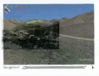
Located an old mining town....

Jim in Idaho

Silver Member
Joined
Jul 21, 2012
Messages
3,362
Reaction score
4,791
Golden Thread
0
Location
Blackfoot, Idaho
Detector(s) used
White's GM2, GM3, DFX, Coinmaster, TDI-SL, GM24K, Falcon MD20, old Garrett Masterhunter BFO
'Way Too Cool' dual 18 Watt UV light
Primary Interest:
Prospecting
I knew this town once existed, but even my old maps didn't agree on where it was. No evidence left. So, tonight I spent 4 hours using Google Earth, and finally matched the old pic, which was taken in 1888. I then printed the pic on clear plastic, and zoomed GE in until the scale was close. I taped the old pic on a screen shot of Google Earth, and scanned it. Here's the old pic alone, and then the combined pic. Now I can locate the old cabins and buildings for some serious detecting. Other than prospecting, this coin and relic detecting of old mining towns is my favorite detecting.
Jim
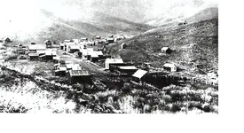
ERA townsite2.webpERA townsite on GE.webp
 

Very nice work what clues did you use to figure out the old town ever existed? Where just generally north south east west Don’t want to intrude in on your work! I am going exploring in Southwest idaho in a couple of weeks
 

Very nice work. Google Earth is probably one of the best tools out there, but it can fool you as to just how steep and dangerous a possible route will be once you are on the ground. The last thing I want to do is get ledge locked! I have spotted several locations that I will never get out to. :{
 

I love seeing the labor's of research bear fruit! Congrats, and keep us posted as to the progress...
 

Very nice work what clues did you use to figure out the old town ever existed? Where just generally north south east west Don’t want to intrude in on your work! I am going exploring in Southwest idaho in a couple of weeks

I've known about the place for many years. It's in the southeast corner of Idaho. To locate it, I just used the geography in the old pic, and matched it up with a 3d view on GE. GE's algorithm isn't perfect, but it's close enough for this purpose. The site, now, is completely bare. That's probably why the maps have it in the wrong place....there's no evidence of buildings, at all.
Also, the printing on clear plastic is messy. The ink doesn't dry very well, so you have to take some care when handling things. But, it works well enough. A better method might be to just put the plastic over the old pic, and draw-in the main details...like the building perimeters, etc. That would be slower, but a lot less messy.
Jim
 

Last edited:
oh wow, I am heading to Caldwell to pick up a jeep I bought at Dennis Dillon. Way less expensive than anywhere in CA ($6,500) I am buying a xterra 705 used and have been remotely exploring the area with google and geologic maps overlays I am going to do some hunting up by silver city > so if you happen to see me I'll be in a white jeep rubicon. give a wave. Good luck !
 

Great application of research !!
Congrats on your discovery.
Don...

Many thanks, Don, but I found out it is now on private land. The good news is I have the address, and phone number for the land & cattle company that owns it. I may be able to get permission to detect it. We'll see.
Jim
 

Good work...and best of luck! 🙌 Hoping this pans out!
 

Top Member Reactions

Users who are viewing this thread

Back
Top Bottom