hung
Sr. Member
- Joined
- Jul 16, 2009
- Messages
- 274
- Reaction score
- 6
- Golden Thread
- 0
- Detector(s) used
- Tubedec A9000, Mineoro FG90, OKM Bionic X4
- Primary Interest:
- Other
- #1
Thread Owner
Hi Folks, I know there are great map dowsers in this forum and I would hugely appreciate if you could make a confirmation or not about two locations.
This past weekend, I went to visit my Wife's uncle. He lives in a farming region and I just for fun decided to take only a couple of LRLs of my arsenal. One being Mineoro FG90 and the other the rangertell examiner. I did not take the complex LRL system we built and is being used by my team.
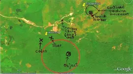
As soon as he saw that I had brought them, he took me to a spot that is marked as Fire Ball Rock. He told me that in that area, he had frequently spoted an orange/redish type 'fire ball' that moved down the hill for some short periods in certain nights.
I have experience about this subject and know for a fact that moving 'fireballs' are result of ionization phenomena over gold veins. When the fireball is still over one spot it means buried treasure.
He also told me that the land owners of that part of the hill have broken several pieces of the big rock in attempt to find gold in it but probably failed.
Over this spot, I got signals from both the Mineoro and the examiner. However we could not get closer as the security watchers spoted us and I had to quickly hide the detectors to not expose our intention.
Back in the house, while the lunch was being fixed, I decided to check with the examiner outside the house for other possible targets. Then I got a signal for gold estimated at 500 feet away and of medium size as the knob was 'in the 6'.
After lunch we went there walking and the FG90 started to beep more intermitently until I got over an almost all buried relatively large stone.
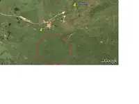
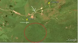
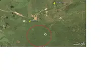
I then picked the examiner with the same settings as before and it confirmed that was the one target I had gotten before. And according to the GPS later it was close to 500 feet away. This is the Moa Rock 1 target in the picture bellow.
The rangertell gave me about 5 feet deep for the target. In the beginning I thought the Mineoro was overtuned and beeping at the edge of the stone due to reflection to the IR sensor. But then I reduced the gain and it continued beeping at the same spot. It was only then that my wife's uncle called my attention to very peculiar marks in the stone I had not noticed before due to my attention to the calibration settings of the device.
The stone had a clear vertical 'chanelling' mark and a round one at left. Then he told me that interestingly enough, it reminded him of a bigger rock that lied ahead some 600 feet which had an X mark in its vertical side.
I imediately thought about Jesuit aproaches in Brazil who used to employ similar techniques in the past.
In the red circle lies the aforementioned probable location of this rock..
Although I could get some sporadic beeps in that direction, due to being late, lack of trail trough the high and dense bushes and also due to the advanced hour, we decided to abort any temptative in this respect at that moment and we made arrangements for him to open a trail during the upcoming weeks and when ready, he would call me again.
I would deeply appreciate if any of you who do map dowsing can confirm or not my expectations and if possible give aditional details on the area shown in the photograph.
Thanks very much in advance.
This past weekend, I went to visit my Wife's uncle. He lives in a farming region and I just for fun decided to take only a couple of LRLs of my arsenal. One being Mineoro FG90 and the other the rangertell examiner. I did not take the complex LRL system we built and is being used by my team.
As soon as he saw that I had brought them, he took me to a spot that is marked as Fire Ball Rock. He told me that in that area, he had frequently spoted an orange/redish type 'fire ball' that moved down the hill for some short periods in certain nights.
I have experience about this subject and know for a fact that moving 'fireballs' are result of ionization phenomena over gold veins. When the fireball is still over one spot it means buried treasure.
He also told me that the land owners of that part of the hill have broken several pieces of the big rock in attempt to find gold in it but probably failed.
Over this spot, I got signals from both the Mineoro and the examiner. However we could not get closer as the security watchers spoted us and I had to quickly hide the detectors to not expose our intention.
Back in the house, while the lunch was being fixed, I decided to check with the examiner outside the house for other possible targets. Then I got a signal for gold estimated at 500 feet away and of medium size as the knob was 'in the 6'.
After lunch we went there walking and the FG90 started to beep more intermitently until I got over an almost all buried relatively large stone.
I then picked the examiner with the same settings as before and it confirmed that was the one target I had gotten before. And according to the GPS later it was close to 500 feet away. This is the Moa Rock 1 target in the picture bellow.
The rangertell gave me about 5 feet deep for the target. In the beginning I thought the Mineoro was overtuned and beeping at the edge of the stone due to reflection to the IR sensor. But then I reduced the gain and it continued beeping at the same spot. It was only then that my wife's uncle called my attention to very peculiar marks in the stone I had not noticed before due to my attention to the calibration settings of the device.
The stone had a clear vertical 'chanelling' mark and a round one at left. Then he told me that interestingly enough, it reminded him of a bigger rock that lied ahead some 600 feet which had an X mark in its vertical side.
I imediately thought about Jesuit aproaches in Brazil who used to employ similar techniques in the past.
In the red circle lies the aforementioned probable location of this rock..
Although I could get some sporadic beeps in that direction, due to being late, lack of trail trough the high and dense bushes and also due to the advanced hour, we decided to abort any temptative in this respect at that moment and we made arrangements for him to open a trail during the upcoming weeks and when ready, he would call me again.
I would deeply appreciate if any of you who do map dowsing can confirm or not my expectations and if possible give aditional details on the area shown in the photograph.
Thanks very much in advance.