OFF SHORE LEASE 1715 SITES?

KINGPULLTAB

Jr. Member
Joined
May 8, 2007
Messages
73
Reaction score
0
Golden Thread
0
Location
VALRICO FLORIDA
Detector(s) used
EXCAL 1000-QUATTRO-SE X-TERRA 70-ACE 250
Daddys302,

First off, welcome to the forum. You wont find a better group of guys here at Treasure Net.

I remember asking this same question back when I was newbie. If you search through the old post you will come across a good bit of information on the 1715 fleet. But here it is in a brief snippet!

You can contact Taffi Fisher-Abt at the Mel Fisher Treasure Museum in Sebastian, Florida. For $1000 you can become a subcontractor for the Fisher's for 1 year. You must supply your own salvage vessel, crew, equipmet and gas. Anything you find is logged, tagged, and turned in to them. At the end of the year, the State takes its royal fifth (20%) and then you split 50/50 with the Fisher's. Basically, you end up with 40% of what you find.

Here are some of the coordinates for the lease areas and they extend 3000' from these center points. Some are elongated to cover the scatter trail. I also recently found out that the Fisher's have exploration permits out to the 3 mile limit that covers most of the coast along the treasure fleet, and you can actually survey and dig in these areas if you are a subcontractor.

BENT ANCHOR S32G 27.55.7N X 80.29.12W; East to 27.55.7N X 80.28.57W; South-southeast to 27.53.28N X 80.27.24W; West to 27.53.28N X 80.27.68W; then follow the mean low tide line to point of beginning.
CABIN WRECK S27 27.49.8N X 80.25.55W is the center point of a 3,000 yard radius excluding all land west of mean low tide line.
DOUGLAS BEACH S26 27.25.3N X 80.16.50W is the center point of a 3,000 yard radius excluding all land west of the mean low tide line.
POWER PLANT S25 27.21.2N X 80.13.65W is the center point of a 3,000 yard radius excluding all land west of the mean low tide line.
ANCHOR WRECK S23 27.48.2N X 80.24.70W is the center point of a 3,000 yard radius excluding all land west of the mean low tide line.
SPRING OF WHITBY S23 27.46.0N X 80.23.83W is the center point of a 3,000 yard radius excluding all land west of the mean low tide line.
RIO MAR S23 27.38.3N X 80.20.90W is the center point of a 3,000 yard radius excluding all land west of the mean low tide line.
SANDY POINT S23 27.35.8N X 80.19.65W is the center point of a 3,000 yard radius excluding all land west of the mean low tide line.
UNKNOWN S23 27.19.0N X 80.12.30W is the center point of a 3,000 yard radius excluding all land west of the mean low tide line.
CORRIGANS WRECK S25 27.46.2N X 80.22.67W is the center point of a 3,000 yard radius excluding all land west of the mean low tide line

If you are looking get your own lease area (not a subcontractor), you must have a valid Florida corporation with Archaeologist on staff. You file for an exploration permit with the State of Florida, which allows you to go out and survey and inventory any wrecks in your permit area. From there, if you find something, you will procede to the next phase which is recovery. And then deacession, or division of the finds. Its not an easy process!

As for who checks on the lease areas, up until a few years ago, Tommy Gore was the States on site representative. But now, I am not sure who is handling it!

Good luck and welcome to the forum!

Robert
 

There is constant fly overs with helicopters and planes. I am sure that subcontractors in the area also report anybody looking like they are doing something illegal.
 

stevemc said:
There is constant fly overs with helicopters and planes. I am sure that subcontractors in the area also report anybody looking like they are doing something illegal.

I'm sure many people believe the area is under the constant watch of enforcement aircraft. I have had the Wabasso to Fort Pierce area under radar surveillance 40 hours a week for over 20 years and it simply isn't so. State contractors do fly down the river and count the manatees and dolphins a few times a year though.
 

You know that is very interesting bcause a few months ago I was under th impression that the same thing was taking place on the Gulf Coast.
The only thing taking place on the Gulf Coast is some tracking of ships from the DEA and Coast Guard, even the Fish and Game people don't have the FUNDS and unless there is some kind of REPORTED POLUTION the DEP wil not check anything out.
If you will recall I discovered an ABANDONED commercail fishing boat with the fuel and oil tanks half full laying in 1 foot of water that was blown into the marsh. I reported this to the State DEP and the County Sheriff of the county it was found in.
They could care less. I then asked if in their flyovers could they tell if the tanks were leaking. I was asked WHAT FLYOVERS . They had no idea what I was talking about.
Of course there are NO permits or leases for any salvage work within 80 miles of this area.
The Gulf is NOT the Atlantic Treasure Coast.
Peg Leg
 

Need a map, not longitude and latitudes. Looking for data. Don't have a gps.
 

Google Earth is a free download and has lat/lon coordinates. It is better than just a map. What specifically are you looking for?
 

Sounds like X marks the spot maps

01.webp
 

excellent map trembull, i believe tom gidus has already worked that spot though!!!! hes very tight lipped about it and will probably deny it.
chuck.
 

I know nothing! :-)
 

Daddys302,

First off, welcome to the forum. You wont find a better group of guys here at Treasure Net.

I remember asking this same question back when I was newbie. If you search through the old post you will come across a good bit of information on the 1715 fleet. But here it is in a brief snippet!

You can contact Taffi Fisher-Abt at the Mel Fisher Treasure Museum in Sebastian, Florida. For $1000 you can become a subcontractor for the Fisher's for 1 year. You must supply your own salvage vessel, crew, equipmet and gas. Anything you find is logged, tagged, and turned in to them. At the end of the year, the State takes its royal fifth (20%) and then you split 50/50 with the Fisher's. Basically, you end up with 40% of what you find.

Here are some of the coordinates for the lease areas and they extend 3000' from these center points. Some are elongated to cover the scatter trail. I also recently found out that the Fisher's have exploration permits out to the 3 mile limit that covers most of the coast along the treasure fleet, and you can actually survey and dig in these areas if you are a subcontractor.


If you are looking get your own lease area (not a subcontractor), you must have a valid Florida corporation with Archaeologist on staff. You file for an exploration permit with the State of Florida, which allows you to go out and survey and inventory any wrecks in your permit area. From there, if you find something, you will procede to the next phase which is recovery. And then deacession, or division of the finds. Its not an easy process!

As for who checks on the lease areas, up until a few years ago, Tommy Gore was the States on site representative. But now, I am not sure who is handling it!

Good luck and welcome to the forum!

Robert
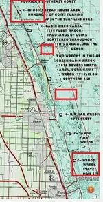
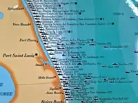
You seem to be the most knowlegable on this. Do I understand the map correctly that there is empty space between some of the lease sites? The reason I ask is because I joined this forum just to ask where I am legally allowed to look for modern jewelry in the shallow water of the beaches. (but I live in Brevard). If I knew the GPS of the leases, wouldn't I be legally allowed to detect for modern jewelry in the water if I'm in between lease sites? This map implies there is non lease sites between them.
 

Attachments

  • Capture.webp
    Capture.webp
    99 KB · Views: 31

Federal Law​

Treasure hunting first falls under the jurisdiction of federal law. The Marine Protection, Research and Sanctuaries Act of 1972 designates underwater sanctuaries to protect natural and historical resources. The Florida Keys National Marine Sanctuary, which contains the fragile coral reef system and a number of known and suspected shipwrecks, is governed by this act, which calls for careful evaluation and inventory of shipwreck sites. The Abandoned Shipwreck Act of 1988 gives title to shipwrecks in Florida waters to the people of Florida. Under this law the Bureau of Archaeological Research monitors all activity on or near wrecks to ensure that scientific research is carried out, the environment is not disturbed and the wreck is not destroyed.

Florida Law​

Florida law follows federal law and expands upon it. The Florida Historical Resources Act covers all navigable bays, rivers, streams and lakes in the state and extends jurisdiction 10 miles out into the Gulf of Mexico and 3 miles offshore into the Atlantic Ocean. Divers must obtain permits from the state Division of Historical Resources before any excavation of an underwater discovery and they have to qualify as professional archaeological experts affiliated with a museum, university or similar scientific or educational institution. Anything they find under the research permit is public property. Failure to obtain a permit is a third degree felony. Exploration and Recovery permits are required for individuals or companies who want to explore or recover artifacts on state-owned lands--including those underwater. All activities must be performed under state supervision, archaeological guidelines apply to any excavation and recovered artifacts are recorded and conserved. By law, a portion of the find may be awarded to the finder.

International Law​

Complications arise when the vessel belonged to a foreign sovereign nation. According to the BBC, the Notre Dame de Deliverance, sank in a hurricane 40 miles off Florida in 1755 and was located by a U.S. salvage company in 2002. The ship is partly in international waters and partly in the Florida Keys National Marine Sanctuary. The Spanish government, which leased the ship from the French West Indies Company, has claimed the estimated $2 to 3 billion cargo. The French government may also have a claim. A Florida judge granted the claim to the treasure salvors but the U.S. State Department says the treasure salvors need Spain’s permission to recover the treasure. The wreck, not yet fully authenticated, remains the subject of complicated legal wrangling, as of 2010.
 

Attachments

  • treasure-coast-ships-map-jacqui-thurlow-lippisch-treasure-coast-florida-map-1024x768.webp
    treasure-coast-ships-map-jacqui-thurlow-lippisch-treasure-coast-florida-map-1024x768.webp
    144.6 KB · Views: 29

Federal Law​

Treasure hunting first falls under the jurisdiction of federal law. The Marine Protection, Research and Sanctuaries Act of 1972 designates underwater sanctuaries to protect natural and historical resources. The Florida Keys National Marine Sanctuary, which contains the fragile coral reef system and a number of known and suspected shipwrecks, is governed by this act, which calls for careful evaluation and inventory of shipwreck sites. The Abandoned Shipwreck Act of 1988 gives title to shipwrecks in Florida waters to the people of Florida. Under this law the Bureau of Archaeological Research monitors all activity on or near wrecks to ensure that scientific research is carried out, the environment is not disturbed and the wreck is not destroyed.

Florida Law​

Florida law follows federal law and expands upon it. The Florida Historical Resources Act covers all navigable bays, rivers, streams and lakes in the state and extends jurisdiction 10 miles out into the Gulf of Mexico and 3 miles offshore into the Atlantic Ocean. Divers must obtain permits from the state Division of Historical Resources before any excavation of an underwater discovery and they have to qualify as professional archaeological experts affiliated with a museum, university or similar scientific or educational institution. Anything they find under the research permit is public property. Failure to obtain a permit is a third degree felony. Exploration and Recovery permits are required for individuals or companies who want to explore or recover artifacts on state-owned lands--including those underwater. All activities must be performed under state supervision, archaeological guidelines apply to any excavation and recovered artifacts are recorded and conserved. By law, a portion of the find may be awarded to the finder.

International Law​

Complications arise when the vessel belonged to a foreign sovereign nation. According to the BBC, the Notre Dame de Deliverance, sank in a hurricane 40 miles off Florida in 1755 and was located by a U.S. salvage company in 2002. The ship is partly in international waters and partly in the Florida Keys National Marine Sanctuary. The Spanish government, which leased the ship from the French West Indies Company, has claimed the estimated $2 to 3 billion cargo. The French government may also have a claim. A Florida judge granted the claim to the treasure salvors but the U.S. State Department says the treasure salvors need Spain’s permission to recover the treasure. The wreck, not yet fully authenticated, remains the subject of complicated legal wrangling, as of 2010.
Appeciate all this but I still don't understand how to find the facts I need to make sure I don't break any laws. I like to detect shallow water like the trough just after the shoreline for modern jewelry. (Just like we do anywhere else). How do I find out if and where the gaps are between leases in case I want to hunt for modern jewelry? I actually joined this whole forum hoping I can find out what GPS coordintates I can detect for modern jewelry. (But I do dry sand for jewelry as another hobby). I happen to live in South Brevard so it would be convenient for me to know if there are gaps between the leases on the shores. How do I find this out? These old maps suggest there are gaps between leases. While it may more convenient for law enforcement to be told just no detects in any water beween Bon Steele and Vero, is that the law or there are gaps between leases?
 

Appeciate all this but I still don't understand how to find the facts I need to make sure I don't break any laws. I like to detect shallow water like the trough just after the shoreline for modern jewelry. (Just like we do anywhere else). How do I find out if and where the gaps are between leases in case I want to hunt for modern jewelry? I actually joined this whole forum hoping I can find out what GPS coordintates I can detect for modern jewelry. (But I do dry sand for jewelry as another hobby). I happen to live in South Brevard so it would be convenient for me to know if there are gaps between the leases on the shores. How do I find this out? These old maps suggest there are gaps between leases. While it may more convenient for law enforcement to be told just no detects in any water beween Bon Steele and Vero, is that the law or there are gaps between leases?
I have given you the cords of the leases, you would have to physically measure off the cords given, there are no written directions to areas between the leases and all you will end doing is getting into trouble.

You say you are in Brevard county so start 3/4 mile north of Sebastian Inlet and you can hunt in the water all the way North, or start 1/2 mile South of Fort Pierce and detect south.
Appreciate you helping and thank you. Are there two overlapping sets of laws perhaps and that is the confusion? I wonder if there might be gaps between lease sites but the state put a secondary law of no detectors in the water from North of Sebastian all the way to Vero Beaches because originally the entire area was a single lease site? It sounds like a nightmare for the courts if the leases touch each other because that would mean someone who is from one leas site could have part of their body laying on another persons lease site. So does the state allow constant litigation of lease holders who have part of their body touching another persons lease site? That would make no sense. When the site boundaries were made, it would have helped avoid a lot of legal problems if they created gaps in between the lease sites because then there would be far less accidental incursion to tie up law enforcement and the courts. If there are indeed gaps between the lease sites, then I would have though it's legal to search for modern jewelry in the trough of the beaches in between. Is this incorrect because the entire Northern most GPS location down to a single Southern GPS location was once considered one site and the state of florida said no detectors? How can I read the specifics of these laws? Another thing I worry about is that while I use to think Bonsteel Park was the Northern most area for "no detectors in the water", I've read that salvage teams have been active in the past North of that like Sunnyleland Beach. How do I check if that is also where no one can search for modern jewerly like the rest of the state?
 

Last edited:
You are making it harder than it is..

You can not detect in the water where the leases are, only from toe of dunes to waters edge.

As stated, I know of no document anywhere that gives the coordinates of the area between the leases as it is a very small area between the leases. It doesn't matter if you are hunting modern jewelry, you will violate the law in lease areas.

As stated before....You say you are in Brevard county you can safely detect starting 3/4 mile north of Sebastian Inlet northward except on Federal shores (Nationam Seashores Patrick AFB, and Space center is off limits) you can hunt in the water all the way North, or start 1/2 mile South of Fort Pierce and detect southward.
This is actually pretty good news. I had assumed there were leases at Bonesteel park and then to the South but you are saying we can detect for modern jewelry in the water starting at 3/4 miles North of Sebastian and long as we stay North of that? That's great. But it kind of makes sense since the coins that were once found on the beach at Bonesteel/Chucks Steakhouse was not from a wreck but a large spill after salvaging so it' doesn't produce anything anymore. But what worries me about detecting water for modern jewerly at Bonesteel is that I heard there was a treasure hunting boat that set up even North of that once. Sunnyland Beach/Archie Carr area. But maybe they just had a temporary operation so it's okay now? Thank you
 

Appreciate you helping and thank you. Are there two overlapping sets of laws perhaps and that is the confusion? I wonder if there might be gaps between lease sites but the state put a secondary law of no detectors in the water from North of Sebastian all the way to Vero Beaches because originally the entire area was a single lease site? It sounds like a nightmare for the courts if the leases touch each other because that would mean someone who is from one leas site could have part of their body laying on another persons lease site. So does the state allow constant litigation of lease holders who have part of their body touching another persons lease site? That would make no sense. When the site boundaries were made, it would have helped avoid a lot of legal problems if they created gaps in between the lease sites because then there would be far less accidental incursion to tie up law enforcement and the courts. If there are indeed gaps between the lease sites, then I would have though it's legal to search for modern jewelry in the trough of the beaches in between. Is this incorrect because the entire Northern most GPS location down to a single Southern GPS location was once considered one site and the state of florida said no detectors? How can I read the specifics of these laws? Another thing I worry about is that while I use to think Bonsteel Park was the Northern most area for "no detectors in the water", I've read that salvage teams have been active in the past North of that like Sunnyleland Beach. How do I check if that is also where no one can search for modern jewelry like the rest of the state?
I may be wrong but I'm under the understanding that you can hunt all florida beaches to the LOW TIDE water line without any problem, Once you ENTER the water then it becomes the property of the lease holder.
Clearly your not referring to DIVING with a metal detector, although personally I find it hard to detect in the water on the ATLANTIC side, because of the wave action, I have seen several people hunting waist deep on the Gulf of Mexico (Gulf of America) side.

It's hard to determine exactly but I'm not sure anyone would say anything if you are wading into the surf 5 feet into the waves ....
Technically you probably would be at the low tide line when the tide goes out... so unless your hunting the lowest of low tides, technically you wouldn't be beyond the low tide line even if you were in the water...

If it's NOT a lease site area, I don't think there is any problem surf hunting anywhere in Florida..

Good luck...
You can hunt from toe of dunes to waterline along the treasure coast, but you can NOT put the coil in the water on the lease sites unless you are working for a lease owner. The state and the lease owners very much do care.
 

Top Member Reactions

Users who are viewing this thread

Back
Top Bottom