I haven't posted here in 14 years though I do check in sometimes.
I've finally achieved my Holy Grail of old maps.
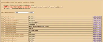
I wrote some software that scrapes names off of old maps and puts them into a database where they can be searched.
Right now I'm only doing Massachusetts, but I have old maps of many other states.
All names on these old maps are hand-written and of varying fonts and sizes and angles, so it's tough for my software to perfectly extract the names and to pinpoint exact locations, but it can narrow things down to a usable search area.


 2286
2286 1423
1423 1387
1387 1369
1369 1116
1116 950
950 822
822 773
773 692
692 586
586 538
538 519
519 519
519 469
469 454
454