Old Placer Ground

jimmygoat

Full Member
Dec 1, 2009
142
6
Northern Cal.
Detector(s) used
Minelab SD2200D-5 inch dredge

Attachments

  • GoogleEarth_Image.jpg
    GoogleEarth_Image.jpg
    262.6 KB · Views: 389
  • GoogleEarth_Image.jpg
    GoogleEarth_Image.jpg
    262.6 KB · Views: 390
Hi jimmygoat! i found some things, but need to mark out locations first. In the upper left corner is old placer ground, SE of that is a neat network of gold veins. Just at the SE edge of the veins is a tunnel. I'm not sure if this is the gold cache you're looking for, it is in the tunnel. More areas of placer ground in spots...will post the photo when finished.
 

Jimmygoat :thumbsup: 
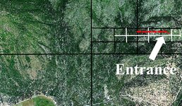
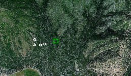
Wow, I surpised to find so many caches. Plenty of old placer mining places here, marked by red Xs. Light colored Xs are caches with silver bars in them. Light circles with a number inside, silver coin caches...1=6-7 feet deep 2=4 feet deep 3 & 4=5 feet deep. Plain light circles are gold coin caches, most under 4 feet deep. Red circles, caches containing gold bars.

Then I found tunnels with a gold bar cache. The area around it is a mass of gold veins running through the spot. :icon_sunny:

Edit-I pulled the marked photo so that his search area is concealed to public view.
 

Wow, where do I start? Well I've got a few ideas. Thanks for dowsing my image Red Desert. Interesting eh Jon? Merry Christmas to all. Jimmygoat
 

jimmygoat said:
Wow, where do I start? Well I've got a few ideas. Thanks for dowsing my image Red Desert. Interesting eh Jon? Merry Christmas to all. Jimmygoat

Interesting, eh Jon? What are you trying to say? I don't understand your question?
Jon
 

Hi Jon, I had you dowse a topo for me of a bigger area as I was looking for something else and you marked almost the same area as Red Desert for the tunnel. :icon_thumleft: Merry Christmas. Jimmygoat
 

jimmygoat said:
Hi Jon, I had you dowse a topo for me of a bigger area as I was looking for something else and you marked almost the same area as Red Desert for the tunnel. :icon_thumleft: Merry Christmas. Jimmygoat

There can be a slight difference between the maps. I've noticed in GE maps of mountain areas...sometimes there is some perspective. When you click grid from the menu in GE, the coordinate grid may in places be running on an angle. This is because of mountain slopes, especially as they run off into the horizon.
 

Hey Jimmy…..Try to locate the cave with your rods…Then just follow it to the entrance..Art
 

Attachments

  • 1115.jpg
    1115.jpg
    270.1 KB · Views: 300
jimmygoat said:
Hi Jon, I had you dowse a topo for me of a bigger area as I was looking for something else and you marked almost the same area as Red Desert for the tunnel. :icon_thumleft: Merry Christmas. Jimmygoat

Hello Jimmygoat,
I had to rewind the mind a ways back to remember you, but I thought this may be you and could'nt remember if it was a map or photo I helped you with.... I can't remember what I did a half hour ago sometimes! (lol) Good to hear from you again. Even if the photo is roughly the same scale as the topo, I feel the picture is better to use. I feel the picture is representation of the surface and a topo is interpretation.
I won't be able to get too in depth on your picture until the 1st of Jan., but I will do a guide dowse (quick scan) for now and research the picture further in a week or so.
Happy Holidays!
Jon
 

Hi Jimmygoat,
I'm going to go with my original dowse I did for you on the topo maps.
In addition, here is what was revealed while going over your picture.
Green square area is a large, shallow pocket of gold placer/nuggets.
White circled areas are gold/silver bars.
White triangle area is a filled in mine shaft.
Thanks for posting your picture,
Jon
 

Attachments

  • tnetjgoatdowsed.jpg
    tnetjgoatdowsed.jpg
    199.8 KB · Views: 199

Top Member Reactions

Users who are viewing this thread

Latest Discussions

Back
Top