Penn Pilot Website - Old Aerial Photos

Kiros32

Bronze Member
Joined
Feb 21, 2006
Messages
1,407
Reaction score
441
Golden Thread
0
Location
Pittsburgh, PA
Detector(s) used
XP Deus, Whites MXT
Primary Interest:
All Treasure Hunting
Jeff posted this site a while back, and it has become one of my most utilized resources. I have found some awesome places to hunt using the old photos on the site.

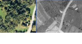
Here are a few examples of how I use it. Using maps.live.com, I type in the area that I am interested (street name and town usually). I then open another browser and find the same area on Penn Pilot. Using some scaling and cut and paste, I make a side-by-side compartive image of the area so I can see the differences in the landscape from then to now. Below is an old farmhouse that I spotted in one of the parks. The black and white image is from 1939, the other is present day. You can clearly see an orchard behind the barn and a planted field to the left of the barn in the older photo.

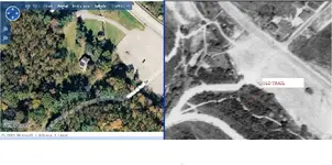
The other image is of another old house here. I was able to spot an old trail in the old photo at the intersection of the main road, that isn't visible on the new photo. Pretty cool eh?

Thanks again Jeff for posting this great site!!!

www.pennpilot.psu.edu
 

Attachments

  • farmhouse.webp
    farmhouse.webp
    52.4 KB · Views: 3,150
  • house2.webp
    house2.webp
    67.9 KB · Views: 3,101
Thanks that's a cool link
Do you blow up the old photos to get more detail?
Thanks again
 

BrianPa said:
Thanks that's a cool link
Do you blow up the old photos to get more detail?
Thanks again

When you find a photo you want to use, click Save to My Photos and select the High resolution image.
 

After I save both the old and new photos. I go into my paintshop pro
program and over lay them. By using a few land marks roads, rivers,
lakes, and such. I can usually get them lined up pretty nice. Sometimes I
will even add the topo to the mix. Then by fading the different layers I
can almost pinpoint the spot I need to search. The last time I did this
looking for and old house lost to the woods we nearly fell over the
foundation stones hiding in the leaves we were that close before we
started looking for the place.

Just my method
Joe
 

this site has been been down for many months now, they said they are working to get it back up, but how long does it take to do that ?
 

this site has been been down for many months now, they said they are working to get it back up, but how long does it take to do that ?

It's up for me.
 

was Just Recently restored Penn Pilot Photo Centers

The Main Map Page was down for a few months. but there was still a Back Door in
if you followed the link to the Historic Maps they supplied
 

After I save both the old and new photos. I go into my paintshop pro
program and over lay them. By using a few land marks roads, rivers,
lakes, and such. I can usually get them lined up pretty nice. Sometimes I
will even add the topo to the mix. Then by fading the different layers I
can almost pinpoint the spot I need to search. The last time I did this
looking for and old house lost to the woods we nearly fell over the
foundation stones hiding in the leaves we were that close before we
started looking for the place.

Just my method
Joe

a friend was able to this for Me.
the Green encircles a 19th Century church Grove

1938-rally.gif

I've never figured out how, I'm not that Computer savy
 

I can do this by using the Overlay feature in GE. First I save an image of the portion of old map, then import into GE using Overlay. It's Hella hard to line up the 1800s maps in GE though.

Sent from my SAMSUNG-SM-N900A using Tapatalk
 

I can do this by using the Overlay feature in GE. First I save an image of the portion of old map, then import into GE using Overlay. It's Hella hard to line up the 1800s maps in GE though.

Sent from my SAMSUNG-SM-N900A using Tapatalk

he has told me he can also overlay the 1875 Beers Atlas township Maps with surprising Accuracy.
Makes me jealous :laughing7:
 

he has told me he can also overlay the 1875 Beers Atlas township Maps with surprising Accuracy.
Makes me jealous :laughing7:
Yes, that's hard to do with those older maps ..as far as getting them to line up. The scale is hard for me to match. I probably just need more practice. When I figured out how to do it, I had a field day with it. You should really have your friend show you how to do it.

Sent from my SAMSUNG-SM-N900A using Tapatalk
 

I'm happy to see that Penn Pilot is back to its normal self!
 

Alas, no photos of this forgotten area.
 

Top Member Reactions

Users who are viewing this thread

Back
Top Bottom