Photos & Map - Treasure Site

ZXCVBNM

Full Member
Joined
Mar 1, 2021
Messages
107
Reaction score
77
Golden Thread
0
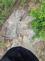
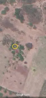
Hello, I would like to post these photos and satellite image to see if what I'm detecting on the ground at this site matches up with what the folks here are able to detect remotely.

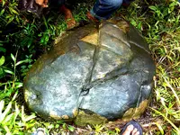
Do others detect anything below this stone?
20211020_155327.jpg


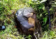
Anything in or around this hole?
20211124_193010.jpg


And how about this satellite image?
signal-2021-11-30-02-30-43-075.jpg
 
Last edited:
Sorry, i'm not coming up with anything other then the usual random dropped coin and what not.
 
Hot rocks? I'm not getting much of anything... on GE map check middle top edge for artifacts, especially non-metallic stone type.
 
I would check the spots I marked.
 

Attachments

  • 558C8BE9-4A45-4149-A76E-4A3F6EEA741D.webp
    558C8BE9-4A45-4149-A76E-4A3F6EEA741D.webp
    1.1 MB · Views: 148
  • 22DC9A9A-3929-48D2-88A8-179C34A2CF03.webp
    22DC9A9A-3929-48D2-88A8-179C34A2CF03.webp
    33.4 KB · Views: 145
Hot rocks? I'm not getting much of anything... on GE map check middle top edge for artifacts, especially non-metallic stone type.
I'm not using any magnetometers, pulse-induction or VLF devices at this site to detect any hot rocks like that from the surface. But signal lines triangulate to a point under the stone from hundreds of meters away. When I performed a resistivity survey on that point using a professional device that actually sends 600 volts, the resistivity of the soil at that time was steadily 180-200 every 1 ft down until reaching 15 ft when it abruptly drops 50% to 90. That's unusual for this area because two other surveys nearby indicated a significant rise in resistivity around 15 ft. This place has a lot of stones under the surface so I can't see why the resistivity would drop like that if something conductive wasn't down there. Check the stone again?
 
Last edited:
I would check the spots I marked.
Nice, that house has been there since the war. It was erected at some point during the Japanese occupation of the area. There is the tip of a perfect pyramid poking out just above the surface over there. Thanks
 
You guys are sure you're not getting anything in the orange circle?

22DC9A9A-3929-48D2-88A8-179C34A2CF03.webp
 
I didn't check for Japanese, but there was obvious archaeological hits top center area of GE map.
 
I didn't check for Japanese, but there was obvious archaeological hits top center area of GE map.
That wouldn't surprise me if something like that was over there. Not far from here there is a large hill. If you walk up to the top the ground is covered with old broken pottery.
 
If this is a Japanese site, then the non-metallic stone artifact should be a carved stone treasure marker?
 
It could be broken pottery, I'd still check for markers though.
 
Checked again, got something Japanese at center top. Is there any way the broken pottery could be Japanese or put there by them?
 
Checked again, got something Japanese at center top. Is there any way the broken pottery could be Japanese or put there by them?
We don't know who put the pottery around there. The patterns on the pottery made it seemed like it was pretty old. But why would it be all broken up and evenly scattered around such a large concentrated area? It was as if someone had intentionally scattered it around that area as some kind of marker. This area was totally locked down during the war. Any Filipinos who got anywhere near it were executed on the spot.
 
The thing that has me doubting about the target below the stone is the material we're excavating seems very compacted and unlike back-fill. It just seems too natural after we got past those larger stones you see there. I don't know if they dug down in another area then tunnelled over to drop the object or somehow managed to very tightly and evenly pack the material back in or what. This sign in the stone is badly weathered but you can see especially the bottom portion and interior appear very symmetrical. The bottom is level with the ground. The little tunnel is going in a perfectly northern direction. If you measure the length of the little tunnel, it goes exactly seven inches in to the stone. The number seven is considered a "lucky number" to the Japanese even to this day.

When you look at this hole in the stone, does it also strike you guys/gals as possibly man-made?

20211020_154135.jpg


20211020_154125.jpg
 
Last edited:
Well, let me try to find my pics of a Japanese carved stone. It was near a cave entrance and inside a small golden sword with Japanese letters on it.
 
Found the sword.
 

Attachments

  • swordfindLG_1.webp
    swordfindLG_1.webp
    257.3 KB · Views: 75
  • swordfindLG_2.webp
    swordfindLG_2.webp
    438.6 KB · Views: 81
  • swordfindLG_3.webp
    swordfindLG_3.webp
    507 KB · Views: 76
Japanese carved rock.
 

Attachments

  • Japanese_stone-carving_1.webp
    Japanese_stone-carving_1.webp
    1.6 MB · Views: 100
Standing back view.
 

Attachments

  • Japanese_stone-carving_3.webp
    Japanese_stone-carving_3.webp
    1.2 MB · Views: 88
Last edited:
I'm getting more signal from the dirt around the hole in close up, mostly area above it. Have you tried panning for gold?
 

Users who are viewing this thread

Back
Top Bottom