PLEASE! I NEED SOMEONE (anyone) TO DOWSE THIS PHOTO!

old digger

Gold Member
Joined
Jan 15, 2012
Messages
7,516
Reaction score
7,364
Golden Thread
0
Location
Montana
Detector(s) used
White's MXT
Primary Interest:
All Treasure Hunting
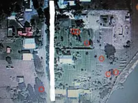
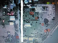
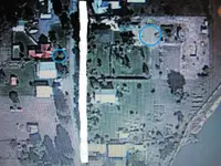
I have been succesful in using the L rods in finding buried water and electrical lines, but haven't been too succesful with maps or photo's. Can someone please tell me if there is anything that may be of interest in this photo. Especially on the right of the center street (white line). I have access to the entire property in the photo. Thank You so Very Much!
folder4 002.webp
 

These hits are all 12 inches or less, marked by the red circles.
 

Attachments

  • folder4 002-old digger.webp
    folder4 002-old digger.webp
    176.6 KB · Views: 162
Thank You So Very Much! I will keep you posted.
Are there any spots that are deeper than twelve inches, that indicate a much greater signal. Thank You!
 

Last edited:
Check out the spot where the green/orange is and a red circle. It could be stuff got deep during construction projects or excavation or if you are researching a lost site, that would be it. Depth ranges from 7-8 feet, 4-5 ft, 3-4 ft.
 

Attachments

  • folder4 002B-old digger.webp
    folder4 002B-old digger.webp
    179.5 KB · Views: 164
Thank You Again! I will check it out ASAP.
 

My first time here. I have friends who say dousing is real, myself, I always thought it was voodoo or..you know, scamming. I have an open mind to all these kind of things, and as of late have been reading up on the phenomanon. Curious if the info from Red desert came to fruition for you? I'm being serious here and not mocking I promise, I'd really like to see it done and who knows, maybe try it myself. It would appear you are using this process to locate things other than water? Like ....? debris or long buried goodies.
 

Last edited:
Red_desert said:
Check out the spot where the green/orange is and a red circle. It could be stuff got deep during construction projects or excavation or if you are researching a lost site, that would be it. Depth ranges from 7-8 feet, 4-5 ft, 3-4 ft.

I dowsed the whole photo. The only place I got anything is exactly where the green x is only. I'd say it's gold. Let me know what you get outta that hole!
 

I'll be gone for at least a week, leavivg in the morning with my parents on a trip south. A couple times green Xs turned out to be gold mines, once the person who owned the old mine, is the one who submitted the GE maps. Old mine are of an archaeological nature. I've also used green Xs on some maps for signs/markers and some have found rock wall carvings in those spots.
 

Hi old digger,Dowsing revealed an attraction to loose silver soins in the areas of the blue circles. Thanks for posting your picture,Jon
 

Attachments

  • folder4dowsed.webp
    folder4dowsed.webp
    168.3 KB · Views: 143

Top Member Reactions

Users who are viewing this thread

Back
Top Bottom