question

gwhitson

Full Member
Joined
Feb 16, 2007
Messages
125
Reaction score
128
Golden Thread
0
Location
nw ar--se ks
Detector(s) used
whites dfx
ive found 2 places around here on googal chrome that looks like this,any ideas
 

Attachments

  • GoogleEarth_Image.webp
    GoogleEarth_Image.webp
    91.3 KB · Views: 116
Upvote 0
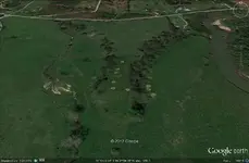
I have no idea what the little tan circles could be. Is there a campground in the area. That would make for some big campsites though. Great map. I need to look into Google Chrome.
 
i know there,s camps in the general area but don't know how close, the map looks like its dead ground with a spring fed ditch on the left and the river on the right
 
I was thinking it looked like bombs or cannon balls had hit it.
 
don't think siloam springs ar was ever bombed
 
The holes look quite big compared to the other homes. Maybe sink holes or drilling sites.
 
ck out the 2nd question and see if they look close
 
don't think so just been looking on that river and saw that, there was a 5 acre field plowed up abut 2 miles from there and he said he picked up over 200 arrowheads and tools
 
So do you think TP
 
don't knowjust wondering if anyone else has seen any formations like this private land or i would find out
 

Users who are viewing this thread

Back
Top Bottom