
You are using an out of date browser. It may not display this or other websites correctly.
You should upgrade or use an alternative browser.
You should upgrade or use an alternative browser.
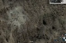
Researching a tale in Iowa. Does this look anything like a skeleton or no?
- Thread starter BeauS
- Start date

invent4hir
Bronze Member
- Joined
- Aug 1, 2017
- Messages
- 2,323
- Reaction score
- 3,906
- Golden Thread
- 0
- Detector(s) used
- Whites V3i & DFX
- Primary Interest:
- Other
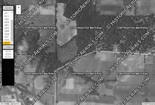
A forest with a 1/4 acre bare spot (except a few trees and a little grass) and a dirt road leading to it from the south. On the 7/2011 Google Earth image there appears to be a lot of erosion in this area. The bare spot has been there since 10/2004. Strange not more trees have taken hold there in the last 15 years. Decimal degrees: 41.17916667°, -92.625°.
Upvote
0
Kansas_Jayhawk
Full Member
- Joined
- Mar 11, 2017
- Messages
- 161
- Reaction score
- 178
- Golden Thread
- 0
- Location
- Southcentral Kansas
- Detector(s) used
- Fisher F75 and Tesoro Silver uMicromax
- Primary Interest:
- All Treasure Hunting
Looks like a head. Eyes being the dark spots.
Upvote
0
BeauS
Jr. Member
- Joined
- Mar 6, 2015
- Messages
- 67
- Reaction score
- 67
- Golden Thread
- 0
- Primary Interest:
- All Treasure Hunting
- #6
Thread Owner
A forest with a 1/4 acre bare spot (except a few trees and a little grass) and a dirt road leading to it from the south. On the 7/2011 Google Earth image there appears to be a lot of erosion in this area. The bare spot has been there since 10/2004. Strange not more trees have taken hold there in the last 15 years. Decimal degrees: 41.17916667°, -92.625°.
what would cause that?
Upvote
0


- Joined
- Apr 24, 2010
- Messages
- 13,021
- Reaction score
- 28,183
- Golden Thread
- 1
- Location
- Upper Canada 🇨🇦
- 🥇 Banner finds
- 1
- Detector(s) used
- XP Deus, Lesche Piranha 35 Shovel & 'Garrett Carrot'
- Primary Interest:
- Relic Hunting
Looks like an area of clay on the surface, hence why no trees have taken root there. 
As nagant already suggested, at some point it might have been 'mined' possibly by Native Americans or early settlers for clay for pottery.
But I'd still head up there, with the landowners permission to investigate, this way you'll know for sure.
Dave
As nagant already suggested, at some point it might have been 'mined' possibly by Native Americans or early settlers for clay for pottery.
But I'd still head up there, with the landowners permission to investigate, this way you'll know for sure.
Dave
Upvote
0


Plug N Play
Bronze Member
- Joined
- Aug 23, 2014
- Messages
- 1,319
- Reaction score
- 3,573
- Golden Thread
- 0
- Location
- California
- Detector(s) used
- De Havilland Canada DHC-7-102 Dash 7 - Fugro
- Primary Interest:
- All Treasure Hunting
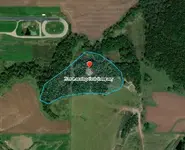
A lot of info. for folks, about Eddyville treasure hunt, on the earlier thread ?
http://www.treasurenet.com/forums/t...one-please-help-determine-exact-location.html
Upvote
0

invent4hir
Bronze Member
- Joined
- Aug 1, 2017
- Messages
- 2,323
- Reaction score
- 3,906
- Golden Thread
- 0
- Detector(s) used
- Whites V3i & DFX
- Primary Interest:
- Other
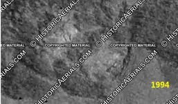
Go to the website Historic Aerials and enter the geocoordinates 41.17916667°, -92.625°. The bare spot was forested on both the 1951 & 1964 aerial photos. The bare spot appears before 1994. Switching to the 2015 topo map, that is the highest elevation overlooking a creek to the north. It is almost as if someone cleared some land to build a home then changed their mind. Between 1964 & 1994, the Eddyville Raceway Park was built just to the NW. Don't know if the 2 are related.
Upvote
0
Reanm8er
Bronze Member
- Joined
- Aug 17, 2018
- Messages
- 2,285
- Reaction score
- 3,560
- Golden Thread
- 0
- Location
- Shenandoah Valley Va
- Detector(s) used
- WW2 Mine Detector, 2 Garrets and an Underwater Fisher (Older Machines)
- Primary Interest:
- All Treasure Hunting
I left those 3D glasses around here somewhere!
Upvote
0
BeauS
Jr. Member
- Joined
- Mar 6, 2015
- Messages
- 67
- Reaction score
- 67
- Golden Thread
- 0
- Primary Interest:
- All Treasure Hunting
- #15
Thread Owner
View attachment 1713880
A lot of info. for folks, about Eddyville treasure hunt, on the earlier thread ?
http://www.treasurenet.com/forums/t...one-please-help-determine-exact-location.html
What's that new lanning coal company?
Upvote
0
BeauS
Jr. Member
- Joined
- Mar 6, 2015
- Messages
- 67
- Reaction score
- 67
- Golden Thread
- 0
- Primary Interest:
- All Treasure Hunting
- #16
Thread Owner
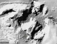
Possibly pine trees or something similar. From a distance you can see maybe a skull, but when you zoom in, it is vegetation of some sort is my guess.
Body buried and jars of gold, this the Eddyville, Iowa story ?
Yep it sure is.
Upvote
0
Plug N Play
Bronze Member
- Joined
- Aug 23, 2014
- Messages
- 1,319
- Reaction score
- 3,573
- Golden Thread
- 0
- Location
- California
- Detector(s) used
- De Havilland Canada DHC-7-102 Dash 7 - Fugro
- Primary Interest:
- All Treasure Hunting
Surface strip mine started in 1965 ... pic as it looked in 1994 ... and more recent pic in color

Last edited:
Upvote
0
invent4hir
Bronze Member
- Joined
- Aug 1, 2017
- Messages
- 2,323
- Reaction score
- 3,906
- Golden Thread
- 0
- Detector(s) used
- Whites V3i & DFX
- Primary Interest:
- Other
Go to the website Historic Aerials and enter the geocoordinates 41.17916667°, -92.625°. The bare spot was forested on both the 1951 & 1964 aerial photos. The bare spot appears before 1994. Switching to the 2015 topo map, that is the highest elevation overlooking a creek to the north. It is almost as if someone cleared some land to build a home then changed their mind. Between 1964 & 1994, the Eddyville Raceway Park was built just to the NW. Don't know if the 2 are related.
Note: 1937 is fairly early for aerial photos on-line. You may want to check with the county engineer or auditor to see if they have any earlier paper copies. While you're there you can examine deeds to see who owned the land when and based on value, if any buildings were on there. Another possibility is to look at old (i.e. 1800s) atlases of the area. They may show land parcels, owners, roads, and perhaps the general location of where buildings were.
Upvote
0

nagant
Hero Member
I think it was an off shoot of other companies. Lots of Lannings in coal mining. From the DNR..Iowa has 300+ Abandoned Mind Land (AML) sites, 13,000+ acres of abandoned coal mines that affect the landscape primarily in SE Iowa. AML sites typically include dangerous piles and embankments, highwalls, subsidence, pit ponds, polluted water used for agriculture and human consumption, and bare acidic soils that pollute water through erosion, sedimentation and AMD.
Upvote
0





Featured Treasure Finds
Featured Treasure Finds
Similar threads

- Replies
- 2
- Views
- 459


Users who are viewing this thread
Total: 1 (members: 0, guests: 1)















