Silver in the park

TerryC

Gold Member
Joined
Jun 26, 2008
Messages
7,805
Reaction score
11,218
Golden Thread
0
Location
Yarnell, AZ
Detector(s) used
Ace 250 (2), Ace 300, Gold Bug 2, Tesoro Cortes, Garrett Sea Hunter, Whites TDI SL SE, Fisher Impulse 8, Minelab Monster 1000, Minelab CTX3030, Falcon MD20, Garrett Pro-pointer, Calvin Bunker digger.
Primary Interest:
Metal Detecting
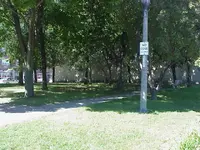
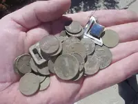
TimC and I hunted this park today for about 90 minutes. It is at 64th and Greenfield (milwaukee). Found just under 2 dollars in clad and the pictured earing. Silver. Can anyone tell me what type of stone that is?
 

Attachments

  • MVC-031S.webp
    MVC-031S.webp
    49.8 KB · Views: 532
  • MVC-032S.webp
    MVC-032S.webp
    20.5 KB · Views: 531
Upvote 0
I'm like you when it comes to spots. Have you used the street view on Google Maps? If not, go to the same Google maps satellite view (aerial view) and click on the street view tab/button. The street view tab is located all the way to the left of the satellite view tab/button. Try fooling around with the street view format on Google maps, you'll be surprised. You can look at someone’s front door. Check it out.
 

Ant said:
I'm like you when it comes to spots. Have you used the street view on Google Maps? If not, go to the same Google maps satellite view (aerial view) and click on the street view tab/button. The street view tab is located all the way to the left of the satellite view tab/button. Try fooling around with the street view format on Google maps, you'll be surprised. You can look at someone’s front door. Check it out.
Yes Ant,
I'm pretty familiar with Googl Maps. I've put several on to it. TTC
 

Hi Terry C.

I believe we are refering to two different things, you might be talking about Google Earth, that’s a different program.

I would like to know how I can post a street view link or photo, not the satellite view from the air.

If you go to this link http://maps.google.com/maps?hl=en&tab=wl and then paste the following address in the search box S 64th St @43.016803, -87.992160 you’ll see what I'm talking about. You can zoom in, drag the picture in a 360 degree view and travel down the street as if you were in a vehicle.
 

Ant said:
Hi Terry C.

I believe we are refering to two different things, you might be talking about Google Earth, that’s a different program.

I would like to know how I can post a street view link or photo, not the satellite view from the air.

If you go to this link http://maps.google.com/maps?hl=en&tab=wl and then paste the following address in the search box S 64th St @43.016803, -87.992160 you’ll see what I'm talking about. You can zoom in, drag the picture in a 360 degree view and travel down the street as if you were in a vehicle.
Ant,
Yes and no. I am aware of Google maps and I prefere.... preferred Google Earth. This is a NEW function for Google Maps! I'll be d**ned! This is better than sliced bread.... better than.... well, never mind. Go down the street.... west. Can we get into Crawdaddy's? NOT! this is a family show! Thanks for the enlightenment dude! Armchair travel will NEVER be the same at this house again! TTC
 

Top Member Reactions

Users who are viewing this thread

Back
Top Bottom