treasurejack said:
Can anyone tell me the known origin & history of these mines?

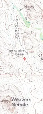
Good question. Of all the other “known” diggings in the Black Top Mesa and Bluff Spring Mountain area, why are these the only ones the USGS decided to indicate on their topo series?
The USGS printed this map (the Weaver’s Needle quadrangle topo) after having knowledge of these mining activities. If I remember correctly, the published USGS Map Key, a separate publication, indicates that an “x” is used to depict a “prospect” site and the “reverse arrow” symbol (head of the arrow placed at the rear) indicates an audit or tunnel site. If we knew the date of publication of the map that was used to create this image, we could be certain that the mines were known by data available to the USGS and the mining activity occurred prior to the time of the map data record and publication.
USGS performs field surveys periodically and publishes updated maps as the older ones are revised. I have a USGS, Florence Arizona quadrangle map that is dated 1900. It is a “1 to 125,000 scale” map and does not have these mines indicated. The map above looks to me like a more detailed map with a different scale than the 1/125,000 series of maps and therefore the mining sites were not included on my 1900 edition even though the sites might have been documented by USGS prior to 1900.
Probably the best source of the older USGS maps will be in local or regional museums and libraries. While researching 18th century Indian settlements in Alabama, I found old charts in the state library and museum that identified the locations of these villages that were mentioned in old local history books.
If claims were filed for these prospects, the State of Arizona should have a database of where, when and by whom the claims were filed.
Tom Kollenborn made notations on a USGS topo map (that appears to be of the same scale as the image above. His notations indicate the location of several camps in the immediate area of these prospects on the slopes of Bluff Springs Mountain. See pages 196, 197, of Helen Corbin’s book, The Bible on the Lost Dutchman’s Gold Mine and Jacob Waltz, 2002. TK may have known more about their history and origins. These old prospects could very well have been original Spanish or Mexican diggings from the 17th or 18th century and later re-discovered by early Arizona prospectors. Or they were diggings by 20th century prospectors.
Since I wrote the discussion above, I found a copy of the USGS 1912 Arizona Mining Districts map. It is a two-part chart and indicates NO known mining districts near Bluff Springs Mountain. Not even the Goldfield District is indicated. See charts at this link:
Chart 1 of 2.
http://menotomymaps.com/map_img.asp?p=map_fdbdown.asp?106&mak=1912_Arizona_mining_district
Chart 2 of 2.
http://menotomymaps.com/map_img.asp?p=map_fdbdown.asp?107&mak=1912_Arizona_mining_district
With this information, I am of the opinion that the USGS had no verifiable or documented mining activity on or near BSM before 1912 to update their maps for the area near Terrapin Pass. Not even the Goldfield District was listed. In might not have existed in 1912; I just don’t remember. Those mine sites may have been known or accessed by folks that kept the locations to themselves and did not file any mining activity or claims.
I am going to try to get information directly from the USGS and see if I can find out when they first posted those BSM mining sites on the topo map. It would be interesting to see if these sites were included on the first publication of the Weaver’s Needle quadrangle and what year it was published.
If I find additional information, I’ll post it here.
Bill
")
Thank you for posting!