The Kiskiminetas Path

deepskyal

Bronze Member
Aug 17, 2007
1,926
61
Natrona Heights, Pa.
Detector(s) used
White's Coinmaster 6000 Di Series 3, Minelab Eq 600
Primary Interest:
Metal Detecting
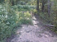
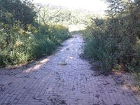
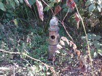
Think I just found an awesome place to detect. I was using Google Earth and overlaying some maps and found an area with what used to be a cluster of houses.
A little more research on the area and I came up with these series of online articles.

I'm going to be doing some scouting of the area this week but I think this is going to turn out to be a productive site......hoping anyhow.

All I'm saying for now is its in Armstrong County and has LOTS of history. Seems to be a fairly easy hike to get to but no current roads to where the houses were now.

These are a pretty good read.
http://www.allekiskitoday.com/articles/1971

There are several parts to it, just follow the links in the articles.

Al
 

OP
OP
deepskyal

deepskyal

Bronze Member
Aug 17, 2007
1,926
61
Natrona Heights, Pa.
Detector(s) used
White's Coinmaster 6000 Di Series 3, Minelab Eq 600
Primary Interest:
Metal Detecting
Okay...besides it being posted no trespassing by Norfolk and Southern, It was a pleasant afternoon hiking.

YES, I ignored the sign. The gate was old, rotted and rusted and the cable was a rusted heap....but the road was drivable.

Near as I could figure, the houses were bought out by the railroad. I found what was the old rail bed, minus the tracks. I found a lot more there than I was counting on. I think now there might have actually been quite a few houses there.

There is a working rail line but you can see how the old line ran to the bridge at one time. The new one doesn't appear to ever use the bridge.

An area where there were brick roads?...seemed kinda confusing for roads and the brick is mortared.....some foundations....turkeys...another blacktop road I didnt see on the map and I followed it to a dead ending with a pretty big parking lot.....and nothing around it. Stripes and everything painted on it for cars.

There was an old fireplug near a bridge..not the area where I thought the original houses should have been so I suspect other later developement that the RR bought out and leveled.

Weeds and woods are incredibly thick right now and getting to where the foundations are is a bit of a challange....but sounds like a good fall treck.

A few pics of the brick road and fire plug by the bridge. And there is definately a curb of some sort along the brick path/road. The pic of the tree is actually a foundation back in there.

Al
 

Attachments

  • 0910081717.jpg
    0910081717.jpg
    134.4 KB · Views: 208
  • 0910081718.jpg
    0910081718.jpg
    119.9 KB · Views: 196
  • 0910081723.jpg
    0910081723.jpg
    142.9 KB · Views: 194
  • 0910081733.jpg
    0910081733.jpg
    128.5 KB · Views: 206
  • 0910081734.jpg
    0910081734.jpg
    106.5 KB · Views: 202
OP
OP
deepskyal

deepskyal

Bronze Member
Aug 17, 2007
1,926
61
Natrona Heights, Pa.
Detector(s) used
White's Coinmaster 6000 Di Series 3, Minelab Eq 600
Primary Interest:
Metal Detecting
More potential than I originally thought.

Used to be called Alleghany Junction....guess it fits under ghost towns now.

Had a population of about 100 in the 1830's and an oil refinery at the junction.

A digitized book on line I found...."The History of Pennsylvania from the Earliest Discovery to the Present"...written around 1880. How fresh the memory then, huh?

http://books.google.com/books?id=Ev...a=X&oi=book_result&resnum=9&ct=result#PPA2,M1

Hope the link works..if not, just google the title.

Al
 

Top Member Reactions

Users who are viewing this thread

Top