artemis moon
Hero Member
- Joined
- Jun 1, 2007
- Messages
- 873
- Reaction score
- 149
- Golden Thread
- 0
- Location
- Near Bangor, Maine
- Detector(s) used
- Minelab Safari
ProPointer
- Primary Interest:
- Metal Detecting
I debated about where to post this, but in the end decided that it's really a What is it:
It was hot last night, and so I took the kids to one of the beaches in our town. We had never been to this particular part of the lake before. I noticed these structures in the picnic area. Here's a little history of the area:
"The size of Harriman Reservoir is impressive, but its history is what grabs your attention. Along the reservoir's floor are remnants of an old logging village that was flooded in the 1920s when the Deerfield River was dammed to generate power.
Harriman Reservoir, also known as Lake Whitingham, is the largest body of water located entirely within the state of Vermont. Enjoyed by boaters, swimmers, paddlers, and fishermen, the reservoir extends about 10 miles from Wilmington to Whitingham in southern Vermont.
The scenic reservoir is owned by TransCanada and is a source of hydroelectricity. Originally developed by the New England Power Company in 1922-23, the reservoir flooded the former pulpwood and lumber village of Mountain Mills, located just outside of Wilmington.
When water levels are low, you can occasionally spot submerged tree stumps and foundations from Mountain Mills. How extraordinary would it be to come across this forgotten little village?"
Here is a postcard of Mountain Mills from the 20's
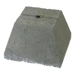
 Here's some of what's left of Mountain Mills today:
  There are three of these pyramidal shaped concrete structures and one square structure that's
 filled in with dirt.
  throughout the park, there are what look like foundations with fireplaces that seem to be made of old stones- possibly from foundations.


Does anyone know what these structures could be?

Here's a map of the reservoir that was created by flooding the town
It was hot last night, and so I took the kids to one of the beaches in our town. We had never been to this particular part of the lake before. I noticed these structures in the picnic area. Here's a little history of the area:
"The size of Harriman Reservoir is impressive, but its history is what grabs your attention. Along the reservoir's floor are remnants of an old logging village that was flooded in the 1920s when the Deerfield River was dammed to generate power.
Harriman Reservoir, also known as Lake Whitingham, is the largest body of water located entirely within the state of Vermont. Enjoyed by boaters, swimmers, paddlers, and fishermen, the reservoir extends about 10 miles from Wilmington to Whitingham in southern Vermont.
The scenic reservoir is owned by TransCanada and is a source of hydroelectricity. Originally developed by the New England Power Company in 1922-23, the reservoir flooded the former pulpwood and lumber village of Mountain Mills, located just outside of Wilmington.
When water levels are low, you can occasionally spot submerged tree stumps and foundations from Mountain Mills. How extraordinary would it be to come across this forgotten little village?"
Here is a postcard of Mountain Mills from the 20's
Here's some of what's left of Mountain Mills today: There are three of these pyramidal shaped concrete structures and one square structure that's filled in with dirt. throughout the park, there are what look like foundations with fireplaces that seem to be made of old stones- possibly from foundations. Does anyone know what these structures could be?
Here's a map of the reservoir that was created by flooding the town
Amazon Forum Fav 👍


Last edited: