Tips for sluice build

GodsEarth

Jr. Member
Dec 27, 2019
28
27
Ontario, OH
Detector(s) used
Bounty Hunter TK4
Primary Interest:
Prospecting
Hey everyone I’m looking for some tips on a cheaper high bank sluice build I’m putting together. My thoughts as of right now (Keep in mind I’m keeping it very budget friendly), is going 10” wide 36”-48” long with Gold Owl matting. I’m making everything out of wood and I’ll have a little 72cc gas powered water pump and 3/4” pvc piping for water delivery. I’ll have the jet holes in pvc shooting up as well as in from the sides.

I’m looking for tips on how much water flow I should aim to have. The pump does about 2300 GPH.

roughly what angle should I have it at? I’ve heard 1” drop per foot.

Is 10” too wide?

I’m building it all out of wood to save some money.

ALL TIPS APPRECIATED! I plan on building it tonight.

Thanks,

Adam
 

Last edited:
Upvote 0
How deep do you usually have to dig in a creek/river?

In Ohio the flood gold can be found in any depth gravel layer but the better gold will usually be found in the gravels on top of the bedrock. How deep to bedrock? It varies.
In the creeks don't bother with outside bends, the gold will be toward the inside bends and where the creek widens or deepens. Anywhere that would be considered a low pressure area is where the gold will drop out of suspension during a flood. Try to picture the creek at flood stage.

To find a pay streak look for where the black sand collects and keep test panning till you find color, usually it's concentrated on the creek side edge of the black sand not so much on the bank side. However, traces can be found anywhere even in the sand bars, so you should get lots of panning practice in during your quest.

Do you know where to get a screen for -100 classification?

Joining this site was the best decision I’ve made. Excellent resources, tips and advice. Thank you all.

Not sure what the mesh is on the splatter screen but it's at least -50


Go for the Gold,
GG~
 

Last edited:
In Ohio the flood gold can be found in any depth gravel layer but the better gold will usually be found in the gravels on top of the bedrock. How deep to bedrock? It varies.
In the creeks don't bother with outside bends, the gold will be toward the inside bends and where the creek widens or deepens. Anywhere that would be considered a low pressure area is where the gold will drop out of suspension during a flood. Try to picture the creek at flood stage.

To find a pay streak look for where the black sand collects and keep test panning till you find color, usually it's concentrated on the creek side edge of the black sand not so much on the bank side. However, traces can be found anywhere even in the sand bars, so you should get lots of panning practice in during your quest.


Not sure what the mesh is on the splatter screen but it's at least -50


Go for the Gold,
GG~

Is there bedrock in the bottom of every creek? I did a google search and it’s not pulling up any information. I dug almost 3 feet deep into the creek today but no bedrock.

That explains why I didn’t come up with any gold today. I dug into the bank side where tons of black sand accumulated not the creek side. Great information thanks!!

Sure there is. The entire earth has a "bedrock" layer. The only problem is the alluvium on top. In some places the bedrock is visible, in other places its over a 1000 feet deep.
 

Sure there is. The entire earth has a "bedrock" layer. The only problem is the alluvium on top. In some places the bedrock is visible, in other places its over a 1000 feet deep.

Hopefully it’s not 1000 feet down lol. Great info! Is there any solid way to estimate the depth to the bedrock? About 4-5miles southwest of me there are creeks with bedrock exposed, water running over it, and waterfalls etc. if this helps.
 

I did the same thing and it worked really well. I used it in a small stream behind where I live that’s where I got those 25-30 colors. I live in the Fairfield area, Hamilton County outside of Cincinnati. I’m hoping to find a place in Clermont County to do some prospecting. It’s only about 30 minutes from me. 54197F4C-9D11-4B0C-BE4F-00C773EA84B5.jpg
 

Hopefully it’s not 1000 feet down lol. Great info! Is there any solid way to estimate the depth to the bedrock? About 4-5miles southwest of me there are creeks with bedrock exposed, water running over it, and waterfalls etc. if this helps.

You need to research geological reports for your area.
 

I have a dandy sluice box made from an aluminum road sign that was obtained from a scrap yard. A machine shop bent it to the correct size. The riffles are made from raised, expanded metal. Any carpet will work under the expanded metal. Nuggets usually stick in the flare and it doesn't have any trouble catching the fine gold. We made it narrow for use in small streams with little water. I also have a larger one that was manufactured but it doesn't work any better and doesn't work at all on the smaller streams.
 

You need to see the geology to know where there is bedrock.

Anywhere in the lower 48 states you can have quick access to all the geologic maps for any area. It's all there in the Land Matters Geology Maps. Thousands of maps ready for download with a few clicks on the map.

Go to the Land Matters Geology map for Ohio. Zoom in to your area by clicking and dragging a box around the area you want to study.

Then
  • Click on the "i" tool on the right of the map.
  • Click on your area of interest.
  • In the window that pops up will be an row named National Geologic Map Database Query. Click on the link that says Click for Map List.
  • A new page will open with dozens of links to bedrock studies and geology.
  • Read, study and enjoy.
Easy enough? :thumbsup:

Heavy Pans

Wow! Thanks Clay! That's some great info :)
 

Perfect I hadn’t come across that website yet, it’s exactly what I needed. Thank you!
 

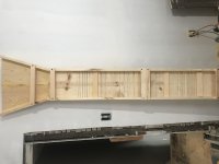
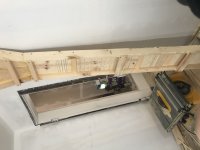
I know I said I was going to skip doing a wood sluice and go make an aluminum highbanker but I decided to make a quick little wooden sluice with some leftover wood I had. It’s 6-1/2’ long and 10” wide ID. Just a quick cheap, free hand routered sluice box (Notice the crooked router lines lol). It took about 2-1/2 hours. Now I couldn’t find stainless steel mesh but I did find some aluminum screen so I’m getting ready to go make that classifier out of a 5 gallon bucket you recommended!

Just throwing out an update on what I’m doing. Thanks everyone
10951499-AA2C-4A98-B65B-FC9FEB4C1940.jpeg2E55BB7A-C704-48BC-86E1-14B7E78CD214.jpeg
 

I’ll be throwing on a coat of epoxy so it stays light and doesn’t get water logged. It’s made out of all 1x boards so it’s no too heavy!
 

Lookin' good,

Great thing about wood is that it's easy to modify to suit your needs after field testing.
Dont forget to have some heavy rocks handy to place on the cross braces.

GG~
 

Looks good but going to be a bit unwieldy to clean out due to the routed riffles.
 

I’ll be throwing on a coat of epoxy so it stays light and doesn’t get water logged. It’s made out of all 1x boards so it’s no too heavy!

There is an epoxy you can get from a marine supply called "Git Rot". It is a very thin penetrating epoxy used to reinforce wood that has some rot it.... Or to just reinforce and water proof the wood.
Used it on commercial fishing boats I had worked on many years ago.

https://www.westmarine.com/buy/boatlife--git-rot-penetrating-epoxy--P004_120_001_009
 

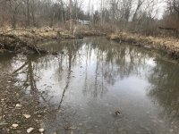
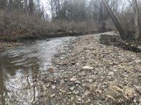
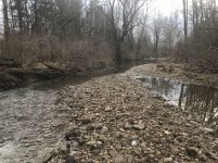
Well I finally have some free time tomorrow to do some prospecting now that the rivers water level has dropped quite a bit. I went down and took some pictures because I wanted to see if I can get some advice on where to be digging since I’ve had no real luck so far. Here are 3 pictures of the area I’m working with.

PICTURE 1
C692CB56-6C53-4A27-9A91-50BF00B63347.jpeg

PICTURE 2
9B013498-DBEC-4C68-94E9-A856BD59A171.jpg

PICTURE 3
89B12A7D-3AA2-4AE9-A95E-8F2EE705CCEB.jpg

Picture 1 is upstream which flows down through pictures 2 and 3.

Thanks,

Adam
 

My thoughts so far were in three spots. The first spot and second spot are in picture one where the river is narrow and widens on both sides, digging on both sides right after it widens up. Then the third spot was maybe where that gravel accumulated where I was standing on at the beginning of it.
 

Where to dig is one thing. the other is where you can set up the sluice to have the right drop and water flow rate. Those 2 things arent always in the same spot
 

Top Member Reactions

Users who are viewing this thread

Back
Top