architecad
Hero Member
- #1
Thread Owner
Hi Fellows
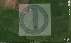
This is a image saved on Google earth. I overlay a image of a "Mars college protractor" to trace the signal with a laptop on field. The image has a 45% of transparency. You should hook a GPS to the laptop and use a compass. The Mars protactor has to match in angle with the Google's compass. Each red line represent the signal broadcasted from the MFD outside with a 1/4 miles radio.
Arch