certman68
Full Member
- Joined
- Aug 10, 2015
- Messages
- 104
- Reaction score
- 64
- Golden Thread
- 0
- Location
- Florida Gulf Coast
- Detector(s) used
- CZ-21
- Primary Interest:
- Beach & Shallow Water Hunting
Just wanted to share a method for tracking hunting locations.
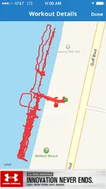
I tried this over the weekend and it worked well. As you can see from the picture below I was at Belleair Beach.
I installed the Map My Run iphone application on my phone. I carry the phone with me in a waterproof case when I'm out hunting.
May My Run is available for Android too and it's FREE.
Map My Run tracks your location via GPS.
Start the application and track your "run" or hunt. Remember to stop your "run" when finished.
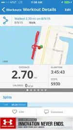
You'll get a map like the one below each time you use it. Overtime you'll build a list of "runs" that you can reference. When was the last time I went to X beach? Where exactly did I hunt? Gives you the fancy features of those high end detectors with the GPS units built in without the cost.
I can be a convenient way to remember where and when you were hunting especially if you move around from beach to beach.
It will also tell you how far you've walked which is sort of interesting.
Hope this is helpful.
P.S. Yes the app has privacy settings you can select to keep you activities confidential or you can share them with select friends.


Last edited:
Upvote
0


