You are using an out of date browser. It may not display this or other websites correctly.
You should upgrade or use an alternative browser.
You should upgrade or use an alternative browser.
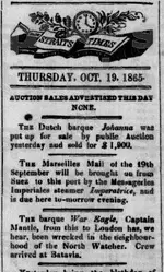
War Eagle - Java Sea
- Thread starter Arch1
- Start date
Alexandre
Bronze Member
Easy. The handwriting is definitely done by someone writing in the 20th century 

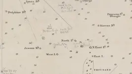
Hand noted one for you- War Eagle '65. The date is a bit confusing as the map is from 1857. Also, if you look just down to the right, it looks like another is noted as being the "Mandarin". Whatcha think? Enjoy!
View attachment 1763585
Cheers;
-Arch1
Alexandre
Bronze Member
Alexandre
Bronze Member
2) American ship "Mandarin"
From the New York Times, 16th Nov 1864 (the year is wrongly noted on the map, 1864, not 1869):
"The Rock on which the Ship Mandarin was Lost.
The following particulars of the unknown reef upon which the ship Mandarin was lost is from a letter received by ELLWOOD WALTER, Esq., Secretary of the Board of Underwriters, dated
BATAVIA, Monday, Sept. 26, 1864.
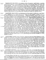
"The ship Mandarin, of New-York, owned by Messrs. WESTON & GRAY, No. 64th South-street, while under my command in the Java sea to the northward of the group of the Thousand Islands, on the 19th of August, at 7 P.M., struck on an unknown reef not laid down on any of our charts. Horsburgh 1845 and 1853, marked in the chart of 1845 as "a safe channel" with from sixteen to twenty fathoms of water. The bearings are as follows: North Island bearing N.N.W.; Small Island to the east of West Islands, due west; the North Watcher just in sight, due north. These bearings and positions are verified by the Capt. of the Government steamer Ambon, that came to our assistance. This reef is about 3 miles in extent running E.S.E. and W.N.W. We ran on and struck on a branch of rocks, with less than 12 feet of water. I refer you to the protest and reports of the Captain of the Ambon and Harbor-Master, for particulars. I would suggest that ships coming through Sunda Straits, not being provided with Dutch charts, should top, or send a boat on shore to the Harbor-Master's, where all the latest charts are to be had, the Government making it a depot for the same. By comparison, there are great and dangerous errors in our charts.
The reef on which we were wrecked is not on any but the latest Dutch charts (of 1863), and not correct on those, it being merely set down as a rock, whereas it is of great extent; and for the time we were on the wreck, it showed no break or ripple."
Batavia
Jr. Member
- Joined
- Jul 29, 2006
- Messages
- 95
- Reaction score
- 28
- Golden Thread
- 0
- Location
- Paris/Jakarta
- Primary Interest:
- All Treasure Hunting
This in front of Jakarta... The moratorium on shipwreck survey/salvage in Indonesia is still in place, unless you are working with a local team of underwater archaeologists.
Last edited:
ivan salis
Platinum Member
- Joined
- Feb 5, 2007
- Messages
- 16,794
- Reaction score
- 3,812
- Golden Thread
- 0
- Location
- callahan,fl
- 🏆 Honorable Mentions:
- 1
- Detector(s) used
- delta 4000 / ace 250 - used BH and many others too
sad but true... these days in way too many places only the archies get to dive on wrecks it seems --- its a damn shame when hard working salvage folks who only want to make a living by recovering and put back into use --the massive amounts of silver and gold lost on various "treasure vessels" thru the years are shut out from earning a honest living --when the powers that be prevent a otherwise honest working man from making a honest living , then he will be forced to make a dishonest one ,,due to needing food , shelter and clothing
seaman for thousands of years made a living recovering goods from shipwrecked vessels ---now that way of living is rapidly dying off it seems ...damn shame ,damn shame I say..as a 300 year family history of going to sea has ended when I retired in 2007 --I was the last of my family line of sea going people --currently there are none of my direct kin going to sea
many things I know about the sea are from knowledge passed down thru the family line ...father to son for about 300 years --so I very unique insights of how sea going folks talk ,think and act --27 years of going to sea myself --8 mouth per year = 18 actual years "on the water" --plus all the hand me down knowledge from my forefathers that flowed from my dad to me
Last edited:
Similar threads
- Replies
- 14
- Views
- 761
Users who are viewing this thread
Total: 1 (members: 0, guests: 1)


