You are using an out of date browser. It may not display this or other websites correctly.
You should upgrade or use an alternative browser.
You should upgrade or use an alternative browser.
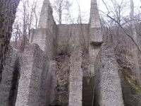
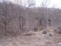
What is this place?
- Thread starter Cjon455/JR
- Start date
diggummup
Platinum Member
- Joined
- Jul 15, 2004
- Messages
- 17,824
- Reaction score
- 10,135
- Golden Thread
- 0
- Location
- Somewhere in the woods
- Detector(s) used
- Whites M6
- Primary Interest:
- All Treasure Hunting
All I see is a dirt road leading into it, no tracks. This thing is huge. Increase the size to 200% and you can see what I mean. It's got to be 250 ft in diameter. Also, there is a house and/or couple structures of some type just to the left of the entrance from the RR yard.diggumup, the bisected circular area is i think an old round track, turn the train
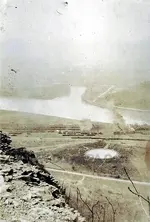
Much larger than this old roundabout-
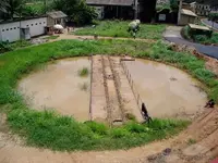
Last edited:
Upvote
0
cw0909
Silver Member
cjon i think a better img of the structure, i still dont know what it was for
PA Duryea 1956 Campbells Ledge
http://www.duryeapa.com/1955to1959/PA%20Duryea%201956%20Campbells%20Ledge.jpg
from pg
Duryea Pennsylvania Historical Homepage 1955 to 1959
original of the above 1956 Campbells Ledge
PA Duryea 1956 Meecha Woming High School Yearbook Pg 74 Annual Staff
http://www.duryeapa.com/1956yearboo...g High School Yearbook Pg 74 Annual Staff.jpg
from pg
Duryea Pennsylvania Historical Homepage 1956 Duryea High School Yearbook
the sanborn maps
PA Duryea 1926 Map Legend w 1938 & 1947 Updates
http://www.duryeapa.com/1920to1929/PA Duryea 1926 Map Index w 1938 & 1947 Updates 1.jpg
this pg has the street maps
Duryea Pennsylvania Historical Homepage 1920 to 1929
home index
Duryea Pennsylvania Historical Homepage
Upvote
0
jackie 1944
Tenderfoot
- Joined
- Nov 7, 2015
- Messages
- 1
- Reaction score
- 0
- Golden Thread
- 0
- Primary Interest:
- All Treasure Hunting
It is located about just off Coxton Dr. in the Coxton region of Duryea, Pa 18707 . It is at the base of Campbells Ledgfe. I doubt that it has a relation to the RR since it is on the other side of , and about 500 yrds from the RR property. I was once told that it had something to do with a quarry .
Upvote
0
Anduril
Bronze Member
- Joined
- Aug 31, 2015
- Messages
- 1,239
- Reaction score
- 1,602
- Golden Thread
- 0
- Location
- South Florida
- Detector(s) used
- Garrett GTI-2500
- Primary Interest:
- Metal Detecting
I agree.
This is probably the old foundations for an aerial crane to transport the (coal?) that was strip mined nearby.
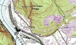
You can see on the topo that the road to transport the coal only goes so far, and then it's still a couple hundred feet above the Coxton Yards where the coal was undoubtedly transported by train. The Susquehanna River is not navigable by coal barge at this location because the water is too shallow, and the bridges are not tall enough.
As for the "round thing" - there are two round things nearby.
One is an old locomotive turntable centered at coordinates: 41.35261, -75.80060.
I think this is technically called a "Roundhouse". (?)
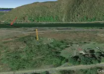
The other round "thing" just looks to be a retention pond, possibly related to the prior mining activity (?).
This pond is located at coordinates: 41.35399, -75.79810
Using the tilt feature in Google Earth, you can pretty clear see it's designed for retention (see Yellow arrow).
It looks like it has a pipe running through the middle, so this could also have been a storage tank retention pond.
Abandoned train tressel at red arrow (likely went to locomotive turntable).
Either that, or a meteor hit it. Does sort of looks like a perfect crater


Upvote
0
Roundhouses were buildings that housed locomotives. The turntable (also called wheelhouse) was the rotating rail device that allowed engines to be directed into specific bays within the roundhouse. Some turntables did not have adjacent roundhouses; they were used only to change the direction of the engine--so that it would always be going forward.
Don......
Don......
Upvote
0
tamrock
Platinum Member
Looks like a coal breaker plant https://en.wikipedia.org/wiki/Breaker_boy Maybe an old cement plant?
Last edited:
Upvote
0
Anduril
Bronze Member
- Joined
- Aug 31, 2015
- Messages
- 1,239
- Reaction score
- 1,602
- Golden Thread
- 0
- Location
- South Florida
- Detector(s) used
- Garrett GTI-2500
- Primary Interest:
- Metal Detecting
Looks like a coal breaker plant https://en.wikipedia.org/wiki/Breaker_boy Maybe an old cement plant?
Wow!
Definitely makes you really appreciate how "easy" we got it these days!!
Thanks for the reminder.
Upvote
0
Anduril
Bronze Member
- Joined
- Aug 31, 2015
- Messages
- 1,239
- Reaction score
- 1,602
- Golden Thread
- 0
- Location
- South Florida
- Detector(s) used
- Garrett GTI-2500
- Primary Interest:
- Metal Detecting
Following up on my prior post:
I'm now not really sure what these structures are?!
I researched some old aerial photos at:
NETR Online ? Historic Aerials
See particularly the 1969 Aerial view (not Topo).
It provides the clearest image of the structure, but I don't see any other structure(s) that would tend to support my prior theory that this was the base for some sort of aerial crane to transport coal. (?)
Also, in looking at several of the "retention pond" or "tank" historical aerials, I might be back to square-one on that also. (?)
Last edited:
Upvote
0
diggummup
Platinum Member
- Joined
- Jul 15, 2004
- Messages
- 17,824
- Reaction score
- 10,135
- Golden Thread
- 0
- Location
- Somewhere in the woods
- Detector(s) used
- Whites M6
- Primary Interest:
- All Treasure Hunting
Not that it matters but the OP of this thread hasn't been on this site for well over 2 years. Still an interesting little area though.
Upvote
0
Anduril
Bronze Member
- Joined
- Aug 31, 2015
- Messages
- 1,239
- Reaction score
- 1,602
- Golden Thread
- 0
- Location
- South Florida
- Detector(s) used
- Garrett GTI-2500
- Primary Interest:
- Metal Detecting
Not that it matters but the OP of this thread hasn't been on this site for well over 2 years. Still an interesting little area though.
I just realized that about a half-hour ago.
New Member "Jackie" updated the post with some new info, which is how it got on my radar screen.
Indeed. I would love to spend a couple days up there metal detecting.
That is, before the snow arrives. (Me and snow don't get along too well.)
Upvote
0
diggummup
Platinum Member
- Joined
- Jul 15, 2004
- Messages
- 17,824
- Reaction score
- 10,135
- Golden Thread
- 0
- Location
- Somewhere in the woods
- Detector(s) used
- Whites M6
- Primary Interest:
- All Treasure Hunting
Yeah, detecting the beach gets old, especially when your more into relic hunting, like myself.I just realized that about a half-hour ago.
New Member "Jackie" updated the post with some new info, which is how it got on my radar screen.
Indeed. I would love to spend a couple days up there metal detecting.
That is, before the snow arrives. (Me and snow don't get along too well.)
Upvote
0
Similar threads
- Replies
- 13
- Views
- 315
- Replies
- 1
- Views
- 157
Users who are viewing this thread
Total: 1 (members: 0, guests: 1)

