TheHarleyMan2
Bronze Member
- Joined
- Feb 27, 2008
- Messages
- 1,594
- Reaction score
- 465
- Golden Thread
- 0
- Location
- Never Know I May Live Next To You!
- Detector(s) used
- GTI 2500/Bounty Hunter
Minelab Equinox 800
- Primary Interest:
- All Treasure Hunting
- #1
Thread Owner
I went to this property and scouted it this past Sunday and the city is going to colonize it with modern day nieghborhoods and commercial property, (Go figure). The grass is about 6 inches high. I plan on going to this sometime this week and Saturday morning if anyone wants to come along. I am going to call the city tomorrow or Thursday as they own it now so I will be seeking permission. There are "NOT" any "No Trespassing Signs" anywhere. So if one thinks that asking for permission would be a waste of time as there are "NO SIGNS POSTED". What is ones oppinion on asking the city for permission if it isn't posted? If anyone wants to go this week or Saturday send me a PM and we can make arrangments to meet.
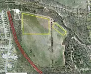
The only way I was able to get to the site was at an end road that the city didn't finish building yet and walking between an undeveloped roadway between some houses, then cross the creek by the 1923 railroad bed outlined in red. I haven't checked out to see if I can go up the bank and cross over the train trussle to gain access without crossing the creek and climbing the steep little bank. The fort is on the upper right of the picture outlined in yellow and the camp position is on the left outlined in yelow. I posted on T-Net about the 1923 railroad crossing. If you look for the thread in General Discussion you will see another picture that shows more of the railroad trussle. Here is some history of the fort and camp which was supposed to haev been there from 1839-1844;
Camp Cazneau; (Located on the left of the picture highlighted in yellow)
Camp Cazneau, 1841, Santa Fe Expedition camp immediately adjacent to Kenney's Fort in Williamson County on the south bank of the Brushy. Expedition camp, east of present-day Round Rock, Camp Cazneau was on Brushy Creek at the Double File Trail Crossing created by Indians passing through the area. It was used in 1840 by the Travis Guards and Rifles under the command of George W. Bonnell when he led raids against the Comanches in May and June of that year.
Kenny's Fort; (Located on the right of the picture highlighted in yellow)
Kenney's Fort First settlement in Williamson County. Erected as a home by Dr. Thomas Kenney and Joseph Barnhart in the spring of 1839. Served as a place of defense during Indian raids. Rendezvous of the Santa Fe Expedition, 1841. Here the archives of the Republic of Texas en route to Washington-on-the-Brazos were captured on December 31, 1842 and returned to Austin.
CAMP CAZNEAU. Two camps seem to have been named Camp Cazneau. The first may have been on a site on Onion Creek just southeast of Austin and near the site of Bergstrom Air Force Base in southeast Travis County. It was occupied by the First Infantry Regiment on March 5, 1840, as they moved from Camp Caldwell to San Antonio. The second Camp Cazneau was 2½ miles east of Round Rock on the south bank of Brushy Creek at the old Double File Crossing, below the Missouri, Kansas and Texas Railroad bridge. It was used by George W. Bonnell when he led the Travis Guards and Rifles in expeditions against the Comanche Indians in May and June 1840. The camp also served as the final assembly point for the Texan Santa Fe expeditionqv in June 1841. The school children of Williamson County erected a monument there in 1925. This site was adjacent to Kenney's Fort. It may have also been the site of the regular-army Camp Caldwell, 1839-40. The camps were probably named for William L. Cazneau, a merchant, soldier, and commissary general of the Republic of Texas.