poorfarm
Full Member
- Feb 13, 2011
- 202
- 21
news flash a friend of mine his brotherinlaw found a metal vest worn by the spanish next to a stream will try to get a pic from him
Thanks. I will be back that way later in the summer. IF, and that's a IF, things go my way, I will post the map. I'm not counting my chickens.Springfield said:Blind.In.Texas said:I found a map. It matched the terrain in every way except one. I went to the place that was falsely represented by the map.
Maps are good, especially if they're genuine. They often remove opinion and speculation from the mix. Good work.
 2003.jpg")
 2003.jpg")
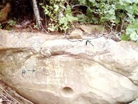
rangler said:senor,
the direction is not pointed out with a 'W' they used compass degree numbers, everytime, I have found an Alpha...in the second Alpha, one of the things to look for is the 3 digit compass heading as below....
rangler said:greetings argonauts and true trackers
The time has come, a sort of crossroads has been reached with graffiti markers and the cloud readers...we must separate them from the confusion they create. So therefore they are NOT welcome to post on this thread.Period. This does not include newbies...they are of course welcome to post anything they find, post to see if it is real or graffiti, so they can learn, these two others have shown they will not learn, so we must leave them behind,.fair warning was given, but when they continue to post graffiti and clouds readings, then now they are confusing people on purpose, and that will not be tolerated here any longer.
via con dios
rangler
The reason we must separate is not only the confusion but the waste of time and resources
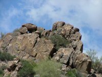
We also want to create and invite the most interested of you members here to participate in a field trip to the Superstition Mountains of Arizona, near Apache Junction,
we you will learn in just a few days what it can take years to learn online.
Also after the field trip, the next outing - we will attend an actual dig site, where we will take an Alpha Monument, find the Omega, solve the final layout and retrieve the goods...
The owner of the site will get the goodies, but we will share the treasure of knowledge, unless you volunteer the site that is...but that is not necessary as I have plenty of my own sites to dig...
At the end of those two events, my book will be ready to be published, and any one who sends in a pic of a monument or even a good sign, that is selected to be published, will received a signed copy gratis...[a note for the negative ones], I am not fishing or trying to get info on your site...so back off that crap right now...after all I have marked for free, hundreds of monuments pics all ready on these sites for anyone who asked...
So the course is clear, the goal is reachable, we just need to move on.
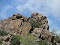
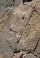
To get you started on the Advanced class this pic is from the Supers., it is my own copyrighted pic. not to be confused with others who photographed this monument,
2003 (c) copyrighted - all rights reserved - rangler
Here's your assignment - to decode the monument,
1.what type of monument is it?
2.is it a Janus monument as well?
3.what is the Indian Face trying to tell you?
4.what are the classic iconic signs displayed here
5.what cardinal direction is it pointing
6.what does it mean
7.can you find distance and direction?
8.what time frame is it from
9.what will be he next sign
10.can you legally take any goodies out of the supers?
there ya go, easy if you know your stuff, easy to look up if you dont,
you need 80% to solve the puzzle and to pass the test.
have fun,
rangler
(c)copyright 2003-all rights reserved- rangler
this is the long shot, taken with a sony digital5megapixel
")
thanks for the input, the info about the gorilla was a long standing supposition for me-as I have found a gorilla head about 80 feet high!Massive Lodes are refereed to as a beast; a hard rock miner might tell one that out of the darkness they come killing like the dragon. Steam, Fire and the Crushing Grip of a ceiling collapse. Violent and dangerous at a whim. Capable of sudden death. Gorilla Heads are in reference to a king of the beasts ahead of you or the richest of lodes running deep into the earth. Right turn Clyde?"
 2005.jpg")

rangler said:springfield,
good question...
"What if the azimuths were intentionally offset by a certain number of degrees from a true north azimuth system (for further security against the curious)?"
truth is - they or at least one group - I followed...mismarked their headings by a certain favorite number of one the order...you had to know this number and if it was negative or positive in nature...without this or some tremendous luck, the cache is hidden forever..
[note: I know that you never ask a question that you dont all ready know the answer to..so
thanks for the confirmation.]
rangler


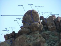
![Janus face - rangler (c) 2003[1].jpg](/data/attachments/523/523396-140bafa4553b35c80cefe8e90c25b705.jpg)