somehiker
Silver Member
- May 1, 2007
- 4,365
- 6,426
- Primary Interest:
- All Treasure Hunting
Looks that way, don't it...........SH.
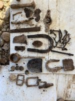
All of the ruins suffered from looting,graffiti,and other vandalism before protections were put in place.
Some are too remote for much protection, like the "cave house" cliff dwelling in Rogers canyon, and are slowly being destroyed by wanton disregard for their value.
All of the ruins suffered from looting,graffiti,and other vandalism before protections were put in place.
Some are too remote for much protection, like the "cave house" cliff dwelling in Rogers canyon, and are slowly being destroyed by wanton disregard for their value.


![Old Spanish Trail Map_thumb[4].jpg](/data/attachments/714/714854-ac98ed5c2f93fdcab515229a75b91254.jpg)