Legends, Maps, Coincidences, Logic, and Hunches.

OP
OP
EE THr

EE THr

Silver Member
Apr 21, 2008
3,979
38
Central California
Thank you, Cubfan. I didn't think it would be that far West.

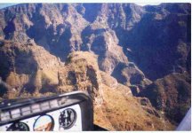
Here is a map of that whole area. The red is current Hog Canyon trails, the yellow is what I had thought was Hog Canyon, the blue spot is Willow Spring, and the green circle is around Weaver's Needle.

Edit: I went back to this image and put Peralta Canyon and Boulder Canyon in green, and Fremont Saddle is at the orange spot.

Peralta - Fremont - Boulder Canyon.jpg


As I said in post #128, and will reiterate here---

"Peralta Canyon looks much easier, and if the route is to go Northward, then turn back south, then the Fremont Saddle route would take you to wherever it is supposed to be, that you're to turn and go back to.

"In view of this, I can't figure why Waltz would use the Hog Canyon area as an entrance point for Julia, can you?

"Or, if Waltz found the mine from the Peralta's instructions or map, as the Chronicle story goes, I have to wonder why they would instruct Waltz to go-in that way, for the same reason as above?"


There are a couple of places on the Net that have legendary directions similar to the #11 of the 13 Clues, from the links on post #102, that I quoted, in post #128, above. What they have in common, among other things, is going "past" Sombrero Butte, which was supposedly what the Mexicans in those days called Weaver's Needle, as it is known today. And also the "going Northward" part. And also going along a canyon all the way until reaching the turn around point.

I can't match any of that up with the Hog Canyon entrance idea. :dontknow:


Of course, Joe, just as you have said many times, "I could be wrong"! And, after all, as far as anyone knows (or has released to the public), it's only a legend, anyway. But a fun one!

:coffee2:
 

OP
OP
EE THr

EE THr

Silver Member
Apr 21, 2008
3,979
38
Central California
I remember reading a year or two ago, that people had reported seeing Waltz enter the Supers from the West. Just basically straight in.

If that were the case, what could that possible route be? Is it a realistic consideration? Does it fit in any way with the site which seems to match so many of the legendary maps and clues?

This is showing what a straight-in entrance from the West could look like, all the way to the final area, using the same map as in post #128. The initial entrance part of this trail is in common use for Superstition hikers, to this day. The route from the West is in orange, and is represented by orange dots where it goes on top of the yellow route. Note that this orange route takes a shortcut from Boulder Canyon across to La Barge Canyon.

The yellow route is supposedly the instructions from the Peraltas to Waltz (as he repeated them to Julia), so it would seem reasonable to keep these directions as simple as possible, thus telling him to go all the way to where the canyons join, rather than trying to specify the exact point at which to cut across to La Barge.

But for Waltz, since he already knew where everything was, there would be no reason not to take shortcuts.

This is a possible West entrance route to what might be the LDM site---


West Entrance.jpg
 

OP
OP
EE THr

EE THr

Silver Member
Apr 21, 2008
3,979
38
Central California
Other stories say that Waltz was seen going to his mine by was of Tortilla Flat.

This would lead down Tortilla Creek, to the junction with Peter's Canyon, as shown on the Google Maps screen shot in post #96, and also in Tom Kollenborn's map in post #90.

From this junction, he could go a short ways down Tortilla Creek, then up a drainage to the hill above his mine from where he saw Four Peaks aligned as one, to the North, and the Needle in the other direction, as shown in post #92.

Or, he could go down Peter's Canyon, to the area of the "Box," and the "Miniature Hidden Valley" below it, as described in Clue #11.

This would be the route down from Tortilla Flat, added in green---


To Ridge - To Mine.jpg
 

OP
OP
EE THr

EE THr

Silver Member
Apr 21, 2008
3,979
38
Central California
But there are more legendary routes to the LDM than just the two in the above posts.

Also on the 13 Clues link, on post #102, clue #13 has this---

"13). Go to First Water, then to Second Water, then take the old Government trail to San Carlos. Where the trail turns south, you will see over the point of the ridge, you can look north and the Four Peaks are lined up to look like one peak. In the other direction you will see a high needle-pointed rock. In the canyon under you is the hidden camp. You can't get down there because it is too steep, but go to the mouth of the canyon and then back. You can find the rock house with very little difficulty. You won't be able to see it until you are right upon it. After finding the camp, come back out of the canyon. Across the canyon and up it is a side canyon. Go up this side canyon to a cave. Opposite the cave is a tunnel and the mine."

The First Water entrance to the Supers is the same as the previously shown West entrance, in orange. The Government trail is anyone's guess, because just about all the trails in the Superstitions were used by the military, at one time or another. If it is meant to be Tortilla Creek, then the route marked, in the map below, in blue, would lead to the point where the "trail turns south"---


First Water to Gov trail.jpg


The smaller red dot is the spot on the hill "above the mine," near the ridge, where the Four Peaks and Weaver's Needle are viewed as described in the legend. This corresponds to where the yellow push-pin is, in post #92.

:coffee2:


If you've been following this thread, feel free to either leave comments here, or vote with the opinion survey in the topic, "Does This Area Most Match the Legends and Maps?"
 

OP
OP
EE THr

EE THr

Silver Member
Apr 21, 2008
3,979
38
Central California
RDT---

You take the wooden trail 3 1/2 varas E.N.E., then go N.N.E until the light comes from your right. Go toward the light as far as you can. The coffee should be easy to see from there.

Don't leave any traces of your being there, or you could have problems later.

:coffee2: :coffee2:
 

OP
OP
EE THr

EE THr

Silver Member
Apr 21, 2008
3,979
38
Central California
Here is another interesting map that never made much sense to me before---

treasmp2.jpg


If you look at the proposed trail from La Barge Canyon to the "Hidden Valley," the shape almost exactly matches. And when you take into account the trail on the map starts below the "box canyon," it really lines up well.

Six Mile Trail.jpg


To me, a box canyon only has one opening, but the one shown on the map looks more like a regular canyon. Although the map shows a totally straight configuration for this, there is a place on Boulder with very steep sides, shown on the right---

Unbox Canyon.jpg


This "unbox" canyon can be seen just to the south of the drainage, inside the yellow circle. Starting from the right of this feature would account for a little more of a downward dip at the maps trail starting point---

Unbox Canyon Trail Start.jpg


Would the route marked in yellow be the easier way to start up the trail? Especially if you happened to be comming from the South? It even shows crossing the drainage in the map, which does look like the best side of it to walk on---

Unbox Canyon Entrance.jpg


One problem with this scenario is that the compass points shown on the map would be wrong. Could this just be "insurance" against the wrong person finding the map?

And then there's those "Red bluffs" in the configuration of a gambline die or domino showing a seven? Hmmm.

And finally, at the top of the map it says, "Distance from camp to shaft & tunnel about six miles." As shown in the map I marked with the line from Four Peaks and the five mile circle, it's actually a little over five miles from Weaver's Needle to my suggested "Hidden Valley." So something is not right there, also. Could the "miles" indicated on this map, actually be in a different unit of measure, as a code?

Also, notice how well the position of the feature labeled, "Jump off --- Very high cliffs," matches the actual terrain at that position.


:coffee2:
 

OP
OP
EE THr

EE THr

Silver Member
Apr 21, 2008
3,979
38
Central California
I thought I'd better make a separate post, for anyone who is the adventurous type, but who is not entirely familiar with the Arizona desert areas, and the Superstition Mountains region in particular.

The superstition Mountains Region is within the U.S. National Wilderness Preservation System, and is managed by the Forest Service. There are limits to what you can do there. Check with the Forest Service before attempting to dig up the LDM, because you will probably only dig yourself into a steep fine or a Federal Prison term.

There are several different types of danger facing anyone who goes into the Supers.

It gets very hot in the summer months, it's very dry, it's very big, and the terrain is very rough.

There are many places where the hills around you look just like every other hill in the area, so you can get very lost, very easily, and stay that way for a very long time.

There are various types of cactus, beyond the common garden variety, which can look interesting and even beautiful, but can be extremely dangerous.

There are all types of animal life, from insects to carnivorous beasts, whose business it is to inflict injury and death to those who might stumble upon them, and of course, they have their natural camouflage and wild instincts, to prevent you from seeing them first.

There are no roads for emergency vehicles to get to you. There is no cell phone service.

Even what would be considered a minor boo-boo practically anywhere else, can easily be fatal out there in the Superstitions.

Here is a list of people who weren't fully prepared for whatever it was they came across last---


Death Toll

The Lost Dutchman Death Roll, on The Life of Adventure Website.

Arizona desert searched for missing Denver man seeking gold mine, on the Denver Post Website, by Kirk Mitchell.

3rd body found in Arizona could be another Utah prospector, on the KSL-5 TV, Salt Lake City Website, story compiled with contributions from Jasen Lee and John Hollenhorst.


...Just sayin'....


:coffee2:
 

Cubfan64

Silver Member
Feb 13, 2006
2,986
2,790
New Hampshire - USA
Detector(s) used
Fisher CZ21, Teknetics T2 & Minelab Sovereign GT
Primary Interest:
All Treasure Hunting
EE - just to add/expand on a couple things you mentioned about exploring in the Superstitions. While I've only been out there on a half dozen trips, I have a perspective of someone who had never seen the desert until my first trip into the Superstitions. Here are just a few of the most poignant things they struck me as a "newcomer" to hiking and exploring out there:

1) I was told that everything out there bites, stings, stabs, sticks, cuts, pokes, poisons or eats meat. That's not an exxageration.

2) If you plan to do ANYTHING off a common/marked trail - wear a white long sleeve shirt, long pants, leather gloves and a wide brimmed hat. NO matter where I intend to go, that's how I dress out there.

3) Take more water than you think you'll need - carry as much as you can

4) Don't rely on a GPS - know how to read a map and take at least one with you and mark it along the way.

5) This is just my observation, but once you get off a trail, it takes FAR LONGER to get somewhere than it looks - consider that if you leave a trail.

6) Again, just my observation, but looking at an overall map of the Superstitions, it doesn't appear that big - that's INCREDIBLY misleading - especially for someone used to hiking the hills and mountains of the midwest and northeast. Again, plan accordingly.

I'm sure I could think of numerous other things, but those were some of my first perceptions upon hiking and exploring out there.
 

Nov 8, 2004
14,582
11,942
Alamos,Sonora,Mexico
Primary Interest:
All Treasure Hunting
Good morning EE :coffee2: :coffee2: :coffee2: :coffee2:

First -- listen to cubber, the only thing that I could change might be the color of the shirt. A brilliant, natural flourscent color might be best for a new comer. Allows far easier spotting in an emergency. Myself, I would be using khakis or a military blend, but then I am used to slipping in and out of a potentially hostile country with the least announcement of my presence -- bandidos...

second -- you posted --> As shown in the map I marked with the line from Four Peaks and the five mile circle, it's actually a little over five miles from Weaver's Needle to my suggested "Hidden Valley." So something is not right there, also. Could the "miles" indicated on this map, actually be in a different unit of measure, as a code?
***************
Nah, but I assume that you were measuring from point to point on your photo / map. As Cubber, oro, joe and a host of others can tell you, forget that system of measurement for foot traffic, it is always far far further. In your last post the projected path includes climbing up and down some very rugged contry which doesn't show up in the photograph.

In exploring I have traveled hard all day long, and only ended up perhaps 5 - 600 meters from where I started, in actuality, and on the map..

See attachment for an example.

Don Jose de La Mancha
 

Attachments

  • Aircraft over the Tayoa complex  ©@.jpg
    Aircraft over the Tayoa complex ©@.jpg
    37 KB · Views: 1,071
OP
OP
EE THr

EE THr

Silver Member
Apr 21, 2008
3,979
38
Central California
Cub---

Thanks for the input, it's much appreciated.


RDT---

I think that's why someone came up with the expression, "as the crow flies."

It's only two miles on the map, from Boulder to the Hidden Valley. But there's some zig-zaging to do, and even that route has some very steep parts, both upward and downward.

I think the entrance down Tortilla Creek, from Apache Trail is a lot better in all respects. It's not a walk in the park, but there's no mountain climbing involved.

The legend says he would go in for three days at a time. The Tortilla route would give him a day to get there, make sure he wasn't followed, and set up camp. Then he would have a day to work. Then a day to pack up, clean the place up, and get out.

But there is also the legend that he alway left by way of the Southern end of the Supers, to throw people off who might be paying attention to his comings and goings.

Anyway, you're right. The maps can make it look a lot easier than it actually is. That's not something anyone would like to be surprised about after it's too late!

Thanks!


:coffee2:
 

Cubfan64

Silver Member
Feb 13, 2006
2,986
2,790
New Hampshire - USA
Detector(s) used
Fisher CZ21, Teknetics T2 & Minelab Sovereign GT
Primary Interest:
All Treasure Hunting
A brilliant, natural flourscent color might be best for a new comer. Allows far easier spotting in an emergency

That's a good point RDT - I was thinking only of what so as to reflect as much sun as possible and long sleeve to protect the arms. I always hate sticking out in a crowd, so I probably would never wear a florescent shirt or vest but you're right it would come in very handy in case of emergency - I'll stick to my white shirt but carry along a cheap lightweight plastic orange vest next time :).

One other thing I thought of - pack your supplies as if you were going to be spending a night or two out there - even if you are just doing a day hike. An emergency night is much better spent with a nice fire (good way to be spotted as well), flashlight and other assorted stuff you might want at night.
 

Springfield

Silver Member
Apr 19, 2003
2,850
1,383
New Mexico
Detector(s) used
BS
And remember this ... there is much, much more trouble awaiting you going downhill. Uphill can be exhausting, but downhill is where the injuries occur.
 

OP
OP
EE THr

EE THr

Silver Member
Apr 21, 2008
3,979
38
Central California
Thanks, Springfield, good point.


Here is an interesting coincidence that I noticed. The map in post #146 has seven circles, labeled "Red Bluffs." An excerpt showing these is rotated 90o, below---

treasmp2 excerpt.jpg


And here is another map with similar circles, but only six. It's called Ray Bradford Map. It also shows a "shaft" and "tunnel," the same terminology as used in the map above---

treasm16.jpg


While other maps indicate the shaft and tunnel configurations, they also use different nomenclature for the shaft, like mine, mino, mina, or pit. So I would call the similarities between these two maps, either evidence of the same origin, or remarkable coincidences.

And what the heck is up with the perfectly symmetrical and similar layouts, and circular representations, of the "rocks" or "bluffs"?

Could these be showing the same area, but just different ways of representing it?

:coffee2:
 

OP
OP
EE THr

EE THr

Silver Member
Apr 21, 2008
3,979
38
Central California
As I stated earlier in this thread, it is based mostly on the maps which are in the public domain. And these types of maps "are a dime a dozen," so to speak.

If any one of the maps were accurate, then whatever they lead to would have been found long ago.

However, something can be concluded from the study of all of them together. That is, by the coincidence that many of them apparently lead to the same quadrant, general area, or place, it could mean something.

If they do indicate the same place, then the question is why? And how could all those people who made each of the maps, each know the target location, and not recover it?

If it was planned to let it remain where it is, for safe keeping, or whatever reasons, then why make so many maps and let them all be floated around so freely?

Overall, it does indicate that for some reason, many people felt strongly about the indicated area, or else why would most all of them, to the extent of their detail or lack of it, be in general agreement? Why that particular area? If they are totally fake maps, then why don't they all indicate totally different areas? Why such a high rate of coincidence?

While a few of the maps appear to be copies of others, to some greater or lesser extent, most others do not. Many are entirely different views, and entirely different interpretations of which landmarks would be important enough to include in a map, of essentially the same target area. Many appear to have been made at different times entirely.

Different times, by different people, from different angles, and different emphasis on landmarks.

Then how can they possibly be total fakes, if they indicate the same target, only in different ways?

:coffee2:
 

Oroblanco

Gold Member
Jan 21, 2005
7,838
9,830
DAKOTA TERRITORY
Detector(s) used
Tesoro Lobo Supertraq, (95%) Garrett Scorpion (5%)
EE THer - I had forgot to add a reply to what you had said about taking the route in by following Tortilla creek; I would not recommend that route. The creek looks like a gentle ascent into the mountains from highway 88 on the maps, but on the ground is a windy thing with thick patches of thorny vegetation, and about a mile or so in from the highway you will find a serious waterfall/cliff that is not for the faint of heart. Tortilla trail is by far much easier to hike than following the creek, and does have some parts (past Tortilla) that are very steep indeed. First water trail is easier hiking in my opinion.

As to your questions on the maps, we could ask well as if they are all real, why then have not they been used to successfully re-discover the Lost Dutchman mine? Clearly something is at fault in those maps. A major one being that it appears Waltz never made one of them, and all of those in circulation seem to have been made by persons who did not know the location, just that it was in the Superstitions so it is quite natural to find the same landmarks on so many when they were composing maps based on what ever set of clues that cartographer had in possession. I doubt that any of the makers of the maps to the LDM/Peralta actually knew the real location of the mine.

Don't mean to be the wet blanket, just cannot put a lot of faith in any treasure map that is in the public domain, and wanted to be sure that anyone reading our discussion doesn't decide to try strolling up Tortilla creek in the misunderstanding that it will prove to be an easy walk.

Oroblanco

:coffee2: :coffee: :coffee2:
 

OP
OP
EE THr

EE THr

Silver Member
Apr 21, 2008
3,979
38
Central California
Oro---

No wet blanket problems, that's what the forum is good for---different viewpoints can possibly make some sense of things.

Just as I mentioned several times in this thread, public domain maps are automatically questionable, as is most any hand drawn map like those. But that's why my curiosity became aroused, because of what they do reveal; not as mere individual maps, but when taken as a group.

My point about the landmarks was, excluding those which are surely copies of each other, many actually use different landmarks to denote the same area. My opinion of these seemingly unusual depictions is that the different map makers had different considerations of which landmarks were the most obvious or major reference points.

This use of different landmarks to show the same areas seems convincing to me that they weren't merely copying previous maps, but that they did have intimate knowledge of the area.

I mean, if someone were copying a map, how could he use different landmarks, which are not on the original map, if he didn't know they were there?

And this seems to occur in more than just a small number of the maps. It seems that the majority of them contain unique features, and leave out other features. While that would be a good ploy to sell a "new" map, the question remains, how did they know?

On the Tortilla stuff, I have never been there. I only know that there is at least one story that says he went in that way. I would assume that anyone going in there would take the best path, and some of the trails around there can even be seen from Google Earth. I don't think there is any "easy" way to get there, however it is evident that people somehow did, and have been for a long time. 8)

(You can see one trail for getting there that way, depicted on Tom Kollenborn's map, in post #90.)

:coffee2: :coffee2:
 

Nov 8, 2004
14,582
11,942
Alamos,Sonora,Mexico
Primary Interest:
All Treasure Hunting
Evening EE, you and oro posted --> If any one of the maps were accurate, then whatever they lead to would have been found long ago-----------------just cannot put a lot of faith in any treasure map that is in the public domain
****************

I agree with the exception of Tayopa and two maps that I have, one from Dobie's 'Apache gold and Yaqui silver'. while I discounted it originally, after I had found Tayopa, it turned to be almost 100 % correct. I have no idea how many used it to look for Tayopa with no success, yet ,when it was understood, it turned out to be correct, except for the transition of two names.

Who knows until it is finally found.

Don Jose de La Mancha
 

Blindbowman

Bronze Member
Aug 15, 2007
2,042
978
Primary Interest:
All Treasure Hunting
sorry this is a little off topic .. i have had a power supply failuar ,and my 1000 watt PS died and i have taken this time to upgrade to i7 at 16gb DDR3 with a 1200 watt PS, with ATI crossfire / LCS . i should be back up and running by the end of next week , till then .....stay safe stay free

:hello:
 

Top Member Reactions

Users who are viewing this thread

Top