You are using an out of date browser. It may not display this or other websites correctly.
You should upgrade or use an alternative browser.
You should upgrade or use an alternative browser.
Old Hand Dug Holes Found And What Took Me There
- Thread starter dsty
- Start date


dsty
Bronze Member
- Thread starter
- #324
Hello Jewel, My opinion about the turtle head has a drill hole for an eye and the head seems to be looking skyward and that may indicate a longer distance as a arrow that's been shot from a bow would have a longer distance than one shot or level with the ground, I can't tell how high it is from the top of its head to the ground but it may tell you how long the trail is, and very likely have markers along the way, If its a corner marker then it may have 3 other direction indicators the head is one, the rear is one, across the eyes indicate two more, if it is a corner marker them all the directions will be true East-- West--- North --- South and it would indicate a square league if it is then I wouldn't be surprised if a 1/2 way marker should be found at 1.25 miles that shows two direction.
Hello Jewel, My opinion about the turtle head has a drill hole for an eye and the head seems to be looking skyward and that may indicate a longer distance as a arrow that's been shot from a bow would have a longer distance than one shot or level with the ground, I can't tell how high it is from the top of its head to the ground but it may tell you how long the trail is, and very likely have markers along the way, If its a corner marker then it may have 3 other direction indicators the head is one, the rear is one, across the eyes indicate two more, if it is a corner marker them all the directions will be true East-- West--- North --- South and it would indicate a square league if it is then I wouldn't be surprised if a 1/2 way marker should be found at 1.25 miles that shows two direction.
Thank you dsty , i will try start spot dig under tail . and i will check the another directions as you told me


dsty
Bronze Member
- Thread starter
- #327
These drawings are what I have found to be very close to what those that came before us carved in stone, Lower left corner S.E. seems to be the start point and the surveyor parties went north and one went west, perhaps a third went 225 degrees N.W. It is my thoughts that at least hundreds and perhaps thousands were involved. It seems that the N. E. corner was the corner with the most interest, Most carvings, The 25 league N.E. corner seemed to be the most interesting because that seemed to be the corner with the vault, I have only seen three vaults, My thoughts were they were more like a store with extra tools and such that could be replaced at that point, and settlers had access to> anyway I have a little more to contribute if you folks would like, PM or ask as you wish. Hope it helps a little. dsty
dsty
Bronze Member
- Thread starter
- #328
Jewel first you must figure out the corner marker that you have how high or there has been posted that are flat, it still showed a rabbit head and a wolf head for directions, my thought's are the nose shows a direction and a rabbit head shows another, there's no reason to dig unless you know where to dig. Will try this method,
Last edited:
Jewel first you must figure out the corner marker that you have how high or there has been posted that are flat, it still showed a rabbit head and a wolf head for directions, my thought's are the nose shows a direction and a rabbit head shows another, there's no reason to dig unless you know where to dig
i draw the directions on the picture and really i don't know how find or know about the ( figure ) or what is mean !! .
and regarding the spot dig in the tail i read some books that the turtle-symbol is the final camp.
i hope get some information about the ( figure ) for my picture . and help if you draw the figure on the picture and put it here .
thank you dsty for your cooperation.

dsty
Bronze Member
- Thread starter
- #332
Thanks for the reply procedure went really great, I was under the bright lights for 3 hours, anurasum was bypassed and no chance for it to burst now. I REALLY do believe that the method I used will work on all of the settlers allotment's wherever they are, but you still need to keep them separate from trail markers, Royal Trail's, trails that lead you into the mountains for mines, trails between settlements and so forth, incoming, fast trails, slow trails. A trail that goes straight up a mountain possible for men setting up camp, winding trails possibly for pack animals, just about all trail markers are used differently, for instance I THINK that along a side of a league square may have separate type of symbol that identifies it a LANE or a strip of land between two properties for all to use for moving animals / supplies and anything else. It took me several years to gather this information and boot leather, I can pass the info on and perhaps you folks will share the trails traveled with me as you go about your ventures I won't be going out in the field anymore but I sure did enjoy the adventure. Thanks Everybody.
Last edited:
oddrock
Hero Member
- Apr 7, 2010
- 560
- 86
- Detector(s) used
- Garrett , Minelab ,White's, others and B.S. sniffer
Dsty
Glad your procedure went well. I have always enjoyed reading your posts and hope you continue. I came across my notes on codes I mentioned awhile back on one of your threads?
Here is an example of two "T codes" as in Clave de Espanol.
T=80
R=1777
U=325
I=400
O=774
E=500
A=1877 So if you have the letters TO try adding 80+774=854 for your distance (may be in varas/may be other measurements) oops ran out of room on "quick reply" will post 2nd code later Oddrock
dsty
Bronze Member
- Thread starter
- #334
Thanks oddrock, There may be so many variables is so many different area's / carvings / writing's and with all the searching in archives in Mexico City , all thru Spain and other's there are possibly lots that remain hidden. I have Not Seen any thing about Royal Trail symbols except C.K.'s well written book, Gale Schaffer's Book that was written in 1980 Dream Garden Press and some of the symbol's that I have seen have been worked out using boot leather and a compass, the 16 X 16 inch drill hole with a flat bottom was a guess on my part as meaning No Carving's for 1 league and travel seem to be where the terrain would support a wagon road, or a winding road with ease of travel. When you find two such drill holes and start I used a topo map and then worked the trail with out finding a single carving, the distance between the two marks are exact altho it may be a greater distance following the wagon road and it could also be a rest stop with a spot that would have a spot for valuables, caves nearby 1/4 mile or so or some other feature, rectangle holes carved into solid rock would be another possibility. I believe that All things should be considered. I also believe that when one gets things figured out you can go from one to the others without any problem
Solomonksa
Jr. Member
Jewel first you must figure out the corner marker that you have how high or there has been posted that are flat, it still showed a rabbit head and a wolf head for directions, my thought's are the nose shows a direction and a rabbit head shows another, there's no reason to dig unless you know where to dig
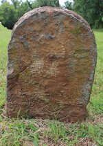
hi dsty , just noted i see the turtle photo for Ms.jewel and the photo is clear appear turtle symbol rock . its not rabbit or wolf
dog the treasure hunter
Gold Member
- Jan 16, 2011
- 5,010
- 5,037
- Detector(s) used
- Time to move on. Good luck everyone .
- Primary Interest:
- All Treasure Hunting
Did these drawing's help anyoneat all
Yes dsty, they helped me. I dont hardly ever copy and save things on here, but those drawings i did. Thanks
dsty
Bronze Member
- Thread starter
- #337
Hello Jewel, at the turtles head there 4 directions, E /W / N/ S, Just go East should be knee high / hip high / waist high / shoulder high markers at selected distances 1320 feet, or 2649 feet or 5280 feet, They will be exact directions and distances. That will verify that you are on a site, I need a photo from far enough away to help you get things worked out. If the corner marker is a turtle or bunny rabbit makes no difference except where the nest will be ( egg laying spot )you will be looking for is a Triangle and its very important to get the distance and direction, the corner rocks will have 2 symbols each and perhaps 200 feet apart. It appears that you have a good site, PLEASE don't start digging anything,
dsty
Bronze Member
- Thread starter
- #338
Hello Mikel, someone said you were writing a book, If there's anything worthy that you want to use that I have posted, feel free. I wouldn't mind a mention somewhere though, or a copy if you don't mind If its not too high and one of the first that's printed same to you THOM or anyone else Thanks and . Good luck
Last edited:
Top Member Reactions
-
 2161
2161 -
 1038
1038 -
 979
979 -
 960
960 -
 865
865 -
 808
808 -
 804
804 -
 700
700 -
 587
587 -
 571
571 -
 464
464 -
 453
453 -
O
452
-
 448
448 -
 446
446 -
 435
435 -
 427
427 -
 377
377 -
 376
376 -
 367
367
Users who are viewing this thread
Total: 3 (members: 0, guests: 3)
