Perdido bay Shipwreck

pcolaboy

Hero Member
Sep 5, 2006
916
14
Pensacola, Fl
Detector(s) used
Minelab Explorer XS
GuyInBlack has a pretty good point and certainly take responsibility for running us off on a tangent. I think I will start a different thread to further discuss any Pensacola Bay wrecks.

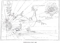
Even though my family has been in Pensacola for generations, there is still very little substantiated history of lower Perdido Bay and Perdido Pass - at least data which is available on the internet. I am going to extend my search of information by going to University of West Florida's library that has a pretty extensive special collections department containing very very old documents, maps, pictures, etc. It's kind of funny because you have to sign a piece of paper saying that you'll not attempt to locate any historic sites or resources from the information you obtain.

Here's what I'll be focussing on from the 1550's to present day:

1. Historical geography of Perdido Pass and navigable waterways to Perdido Bay and River
2. Land ownership plats and land use information
3. Colonial-era settlements (I know there was one on the Alabama Side of Perdido Bay where a large development of homes were built and there is even an old Spanish cemetary there)
4. Verify the location of the old Spanish ferry that ran across the middle of Perdido Bay. I believe this is where part of Galvez's forces crossed to encircle the British and Creek Indian forces during the Siege of Pensacola in 1781.
5. Try to narrow down the location of the first Mobile-Pensacola road that utilized the ferry system. The British established another Mobile-Pensacola road much further north that crossed the river instead of the bay when they took over the West Florida territory 1763. It is widely believed that this route closely follows Hwy 90 for a majority of the path and was later erroneously included in the "Old Spanish Trail" paved road project during the 1920's.
6. Obtain the latest soundings of Perdido Bay performed by the NOAA and compare with any old maps I find with soundings and develop a likely area for shipwrecks. This shouldn't be too hard to do since a majority of the bay would not be passable by anything greater than a 7 foot draft.

Any other suggestions for data acquisition are welcomed!

Pcolaboy
 

Chagy

Bronze Member
Dec 20, 2005
2,226
121
Florida
Detector(s) used
JW Fishers Pulse 8X
Primary Interest:
Shipwrecks
GuyInBack said:
I believe Chagy has just added another whole bunch of ships into the mix. This site is just loaded with lots of more information.

Thanks Chagy ;)... a zillion more leads!!!

http://www.de-luna.com/Locating-Ochuse.html

These are the same ones posted by Ivan in post #3 I just used a different source......most of the info. provided by Ivan can be found in "Shipwrecks in Fl waters" by Marx........I only use Marx and Potter as a guide or starting point...then I move on to "armada espanola" by fernandez duro and "seville et l'atlantique" by the Chaunu brothers......

Here is some new info.......

****Stede Bonet buried 3 million in loot under Ft. San Carlos, Pensacola it has never been found

****Billy Bowlegs buried 76 millions on an island facing Choctawhatchee bay....THunters have done many finds in those islands over the years....there is also 5 million in gold of Bowlegs loot in the west pass to Apalachicola bay.

****Sunken blockade runner in the mouth of the Steinhatchee river with 5 million in coins

****sunken scooner in the mouth of the St. Andrews bay with 1500 gallons of rum worth 250K

****unidentified galleon with sunk in 1819 with 2 million in gold and silver, in Apalachicola bay


GO GET IT BOYS!!!!!!!
 

ivan salis

Gold Member
Feb 5, 2007
16,794
3,809
callahan,fl
🏆 Honorable Mentions:
1
Detector(s) used
delta 4000 / ace 250 - used BH and many others too
I like these 3 for "starters" --- #1 singer --shipwrecks of florida--a comprehensive listing #2 marx-----shpwrecks in florida waters #3 potters--- the treasure divers guide (revised edition) can be tough to find this one-----duro has some fine info in "armada espanola" (but being it was put out in madrid / 1904 is hard to find and of course is in spanish) ----of course my sources run much deeper just these handful of books ---these are just the tip of the iceburg-- both my methods and private sources are closely guarded by me due to their great value needless to say)---- there are folks that don't know how to or want to do the research that can help them hit that "big one"---thats were I step in at ---I give them a very small high probibilty area to focus their search in ---thus cutting down on wasted time ,effort and money-----they get 90% of the net ---I get 10% of its net worth and since I work on a no find =no pay basis they have no risk and no upfront cost only after my information "produces" do I get paid---everyones happy that way---- Ivan
 

Chagy

Bronze Member
Dec 20, 2005
2,226
121
Florida
Detector(s) used
JW Fishers Pulse 8X
Primary Interest:
Shipwrecks
Ivan,

I think thats fair enough.....I most add to the conversation that research is not only in books and archives some of the most valuable information I have always got it from the local fisherman and lobster divers

All the best,

Chagy......
 

pcolaboy

Hero Member
Sep 5, 2006
916
14
Pensacola, Fl
Detector(s) used
Minelab Explorer XS
Still waiting for the secrets.... ;D

Singer's book does make mention of a "spanish wreck in a river near Warrington, FL before 1763."

This rather vague entry does give a few clues however. The original Warrington village was located onboard present-day Pensacola NAS. The nearest true river to old Warrington was....you guessed it...Perdido River approximately 10 miles to the northwest. Parts of Perdido Bay, however, are even closer "as the crow flies".

Another clue to the entry was "before 1763". This makes me believe that a report may have come from the British who took over the West Florida territory that year and may have reported discovering a wreck.

The reference from Singer's entry was Bob Marx's book which I do not have a copy of. If anyone can find this entry in Marx's book and see if there is anymore information there?

Pcolaboy
 

Chagy

Bronze Member
Dec 20, 2005
2,226
121
Florida
Detector(s) used
JW Fishers Pulse 8X
Primary Interest:
Shipwrecks
I have Marx book I will look for it tonight......I am in my office right now.....
 

pcolaboy

Hero Member
Sep 5, 2006
916
14
Pensacola, Fl
Detector(s) used
Minelab Explorer XS
I've put together a Google Earth "Flyby" of the path I believe was near the original course of the Perdio Pass, Bay , and River system. The "flyby" starts at present day Perdido Pass but keep in mind the exact spot has shifted many times over the years and in fact there are historical accounts where the bay would go through long periods being totally cut off from the Gulf. This route initially comes through the pass and hangs a right to the east following the waterway now known as "Old River" - named for a good reason as you will see.

If you're not familiar with using .KML files with Google Earth, simply double click my attachment once you've saved it locally to your hard drive. Google Earth should open. Now on the left pane, you should see my .KML file folder opened showing many points with check marks. Press the triangular button (play button) immediately under this pane to start the flyby (tour). You can change some of the speeds and options for the tour if you wish by going into Options within Google Earth and selecting the Touring Tab.

View attachment Perdido Waterway.kml

Enjoy,

Pcola
 

OP
OP
G.I.B.

G.I.B.

Gold Member
Feb 23, 2007
7,187
8,537
North Central Florida
🏆 Honorable Mentions:
1
Detector(s) used
CTX 3030 / GTI 2500 / Infinium LS / Tesoro Sand Shark / 1 Garrett Pro-pointer / 1 Carrot / Vibra Probe 580 (out on loan) / Lesche M85 / Mark1 MOD1 EyeBall
Primary Interest:
Other
Great job on the fly thru, technology is a wonderful thing. It’s interesting just after frame 13 where you can see the river trying to cut back into the Gulf. The homes won't last during the next change, not very long anyhow. Who knows, maybe one day soon we will see a new entrance again.

I’ve been digging into the weather a bit to see when the mouth may have changed. So far the best bet I have, based on the navigation charts showing the river changing, is in 1837.

October 2nd-6th, 1837: The first recorded storm to rake the entire coast was Racer's Storm on October 5th, named for a British sloop of war which encountered the storm in the extreme Northwest Caribbean on September 28th. It is remembered as one of the most destructive storms of the 19th century due to its extreme duration and 2000 mile long path of destruction.

The 1837 Racer's Storm was one of the most powerful and destructive hurricanes in the 19th century, causing heavy damage to many cities on its 2,000+ mile path. The Racer's Storm was the 10th known tropical storm in the 1837 Atlantic hurricane season.

On October 5 the hurricane passed Galveston, Texas, and continued its northeast movement. The Racer's Storm made its third landfall near Venice, Louisiana on the night of the 6th, and moved eastward across Louisiana. From here, its history is unclear. Some historians track the hurricane to the northeast across Mississippi and Alabama, while others say the hurricane moved eastward, re-emerged into the Gulf of Mexico, and hit Pensacola on the 7th. Regardless, the hurricane was moving northeastward through Georgia.

There is an account it Texas that shows the power of this particular storm. What I find interesting is what it says about the bay changing and how far inland the ships went.

“Then it was Galveston's turn. A storm surge of 6 to 7 feet higher than the spring tide inundated the coast. The scene on the island was one of utter desolation. Nearly all the homes on the island were blown down; all provisions were lost. The new Tremont hotel and two churches also were blown over. Water levels at Houston rose 4 feet. The whole character of the harbor entrance shifted during the hurricane. Ships were shoved as far as 3 miles inland. A long three masted bark was driven 5 miles inland on the ensuing storm surge. Two Texas Navy schooners were dashed to pieces on Galveston Island.”

Now I just have to find some first person accounts from Pensacola of the storm and the mighty Perdido river…
 

CaptJohn

Full Member
Sep 6, 2006
180
27
Fairhope Alabama
Primary Interest:
All Treasure Hunting
I have been shrimping in Perdio bay many times. There is a spot towards the lower eastern point that sticks out into the lower part of the bay from the Fl side, north of the intercoastal that I have hit a snag before. It stoppped the boat and I had to pull the net up, but it did NOT hang or stay tangled, it came up free and un torn. The water is about 8 feet deep there and seemed to slope off to the west to a somewhat deeped depth.
I currently have a 16' ft tri hull boat that only has a 10 hp motor on it. If I can be of any use let me kown... I should have a 18' cabin boat with a 75 HP by this fall ready to go. It sounds like a great adventure!
OH! my son knows of the location (a friends lot) that pieces of the old type clay smoking pipes have been found on the shore line of Perdio Bay!
 

pcolaboy

Hero Member
Sep 5, 2006
916
14
Pensacola, Fl
Detector(s) used
Minelab Explorer XS
CaptJohn said:
I have been shrimping in Perdio bay many times. There is a spot towards the lower eastern point that sticks out into the lower part of the bay from the Fl side, north of the intercoastal that I have hit a snag before. It stoppped the boat and I had to pull the net up, but it did NOT hang or stay tangled, it came up free and un torn. The water is about 8 feet deep there and seemed to slope off to the west to a somewhat deeped depth.
I currently have a 16' ft tri hull boat that only has a 10 hp motor on it. If I can be of any use let me kown... I should have a 18' cabin boat with a 75 HP by this fall ready to go. It sounds like a great adventure!
OH! my son knows of the location (a friends lot) that pieces of the old type clay smoking pipes have been found on the shore line of Perdio Bay!

Hey Capt,

Out of curiosity was that snag near Tarkiln Point ?

Pcolaboy
 

MichaelB

Sr. Member
Aug 13, 2005
463
95
Mobile Bay, Alabama
I found this in a copy of an old book about Mobile. I know the quality is bad but it gives you an outline of the Bay in 1698.

MichaelB
 

Attachments

  • pcola bay 1698.jpg
    pcola bay 1698.jpg
    174.1 KB · Views: 848

ivan salis

Gold Member
Feb 5, 2007
16,794
3,809
callahan,fl
🏆 Honorable Mentions:
1
Detector(s) used
delta 4000 / ace 250 - used BH and many others too
hey when it comes to doing "heavy" type research getting a old map or document at all is good -----asking "is it in good shape?" is really almost too much to hope for--- the old spanish archive stuff is often the pits----Ivan
 

CaptJohn

Full Member
Sep 6, 2006
180
27
Fairhope Alabama
Primary Interest:
All Treasure Hunting
P'Cola, That snag was to west /northwest just a touch/ of the center tip of the point that 297 ends near, Inneraity Point. Out in the water Right about the Al Fl line.
 

pcolaboy

Hero Member
Sep 5, 2006
916
14
Pensacola, Fl
Detector(s) used
Minelab Explorer XS
CaptJohn said:
P'Cola, That snag was to west /northwest just a touch/ of the center tip of the point that 297 ends near, Inneraity Point. Out in the water Right about the Al Fl line.

Interesting....I've definitely set many a gill nets around Innerarity Point. We usually gig quite a few flounder on the big shoal on the north side of the island as well. There's also some interesting snags just off the entrance to Tarkiln Bayou as well in 6-8 feet of water that we 'found' while fishing for reds. I'll definitely shoot some sidescans in those area and the one you mentioned. Once I get the scans, I'll post them on the forum.

Pcolaboy
 

divewrecks

Bronze Member
Sep 7, 2004
1,038
24
Down South - Marietta, GA
Detector(s) used
Minelab Explorer SE (land), Aquapulse AQ1B (sea), Fisher CZ-20 (water, beach), Fisher 1266X (woods)
Chagy said:
I have my gear ready and I am looking for my car keys ;D :D :D
this is one of the best threads I have read in a while.....Good sutff guys...
My thoughts exactly. Sign me on....Stan Dilcher
 

divewrecks

Bronze Member
Sep 7, 2004
1,038
24
Down South - Marietta, GA
Detector(s) used
Minelab Explorer SE (land), Aquapulse AQ1B (sea), Fisher CZ-20 (water, beach), Fisher 1266X (woods)
GuyInBack said:
The final test will be in seeing who actually gets wet and has a good credit card when the actual searching begins.

Not worried about getting a little wet and have good plastic. Stan Dilcher, Marietta, GA
 

OP
OP
G.I.B.

G.I.B.

Gold Member
Feb 23, 2007
7,187
8,537
North Central Florida
🏆 Honorable Mentions:
1
Detector(s) used
CTX 3030 / GTI 2500 / Infinium LS / Tesoro Sand Shark / 1 Garrett Pro-pointer / 1 Carrot / Vibra Probe 580 (out on loan) / Lesche M85 / Mark1 MOD1 EyeBall
Primary Interest:
Other
All in favor of electing Pcolaboy, "comodoro de la expedición perdida del río"

please raise your search coil...
 

ivan salis

Gold Member
Feb 5, 2007
16,794
3,809
callahan,fl
🏆 Honorable Mentions:
1
Detector(s) used
delta 4000 / ace 250 - used BH and many others too
I second him to be "the commander of the expendition of the perdido river"-- guy in back should be first mate--I'll be the cook and bartender ---ivan
 

Top Member Reactions

Users who are viewing this thread

Top